We'd like to thank our incredible community for your support of the 2022 Spring Campaign. We raised $75,000 in two weeks to help grow our avalanche forecasting program. Thank You!
NOWCAST-
Under clear skies, a southwest flow developed overnight and temperatures remained mild, currently registering in the mid 20's, or about 10 degrees warmer than yesterday at this time. Southwest winds bounce between 20 and 25 mph along the high ridges. Riding and turning conditions are excellent as the midweek storm delivered 6"-8" of snow, providing a nice coat of white paint and a much needed refresh.
FORECAST-
Look for partly cloudy skies with temperatures climbing into the mid 40's. Southwest winds bump into the 30's and switch to west and eventually northwest as a dry, cold front slides through the area late in the day. Overnight lows dip into the low 20's.
FUTURECAST-
A mostly sunny day with slightly cooler temperatures is on tap for Sunday with a chance of storminess developing late Monday. The computer models are still attempting to get a handle on this system and I'll have a better idea of strength and timing for tomorrows update.
This is the time of year the time of year the Uinta's shine. Bo, Andy, and I found excellent cold, shallow, cream on a very supportable base... travel is seamless and the livin' is easy :)
Trip reports and snowpack observations are found
HERE.
Looking for real-time temps, snow, or wind? Click HERE and then on the "western Uinta" tab for western Uinta specific, weather station network.
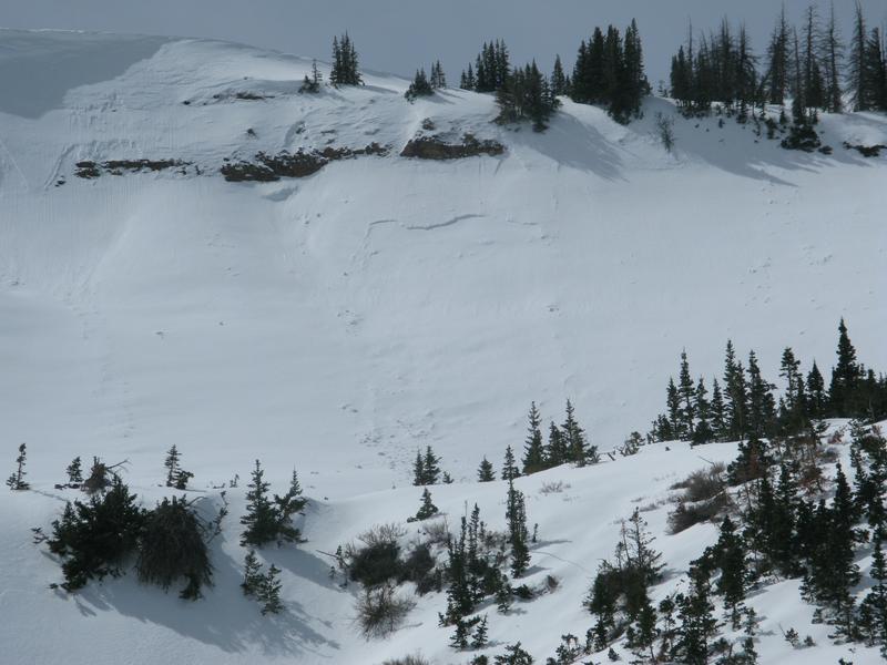
We spotted this interesting pocket yesterday which was most likely triggered a few days ago. It looks like a damp piece of snow dribbled from the steep rock band, crashed onto the slope below, and broke to the Jan/Feb weak layer.
No other significant avalanches to report.
An archive of recent slides is found
HERE.