Sign Up for the Utah Snow and Avalanche Workshop (USAW) on December 7th!

Forecast for the Salt Lake Area Mountains

Nikki Champion
Issued by Nikki Champion on
Friday morning, March 4, 2022
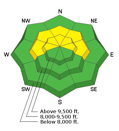
There is a MODERATE avalanche danger for triggering soft slabs 1' to 2' deep, failing on a buried persistent weak layer on mid and upper elevation steep slopes facing west through north and east.

With cooler temperatures and increased cloud cover, the snow on southerly facing slopes shouldn't heat up too much today to cause many wet avalanches but pay attention to changing conditions and be prepared to alter your plans if you see the snow heating up and becoming wet.
Heads up! With new snow in the forecast, the avalanche danger will be on the rise starting this afternoon. Avalanche danger will likely remain elevated through the weekend and into early next week.
Low
Moderate
Considerable
High
Extreme
Learn how to read the forecast here
Special Announcements
Join us on Wednesday, March 9th at the Broadway Theater in SLC for a special screening of the award-winning film “BURIED,” a feature-length documentary based on the events and circumstances surrounding the 1982 avalanche in Alpine Meadows, CA. The show starts at 7 pm. Purchase tickets HERE.
Weather and Snow
This morning, there are a few clouds in the sky and mountain temperatures are in the low and mid-30s °F. Upper elevation temperatures, near 11,000' have finally dropped below freezing, while some lower elevation trailheads are still sitting near 40 °F. Winds are blowing from the southwest at speeds of 10-20 mph, with the upper elevation ridgelines hitting gusts near 30 mph.
Today, Warm southerly to southwesterly flow and moderate winds will accompany the incoming trough, with snow showers kicking off mid-morning. This morning will start mostly cloudy, before snow showers begin and peak around noon. We can expect 1-3" of new snow before the sun sets this evening. Mountain temperatures will climb into the upper 30s °F. The winds will be from the southwest and blow at speeds of 10-25 mph throughout the day. Upper elevation ridgeline gusts could reach 45 mph.
Overall, this wave today will contribute a very small portion of the storm totals, with the main event still to come Saturday evening through Sunday morning with a much more potent system that will finish with a more favorable west to northwest flow. The question is, how much snow will we get. The NWS is reporting anywhere between 14-20" (1.25-2.25" water) of new snow. The new LCC Guidance rings in with another solution of 27" (1.79" water) of new snow by Monday evening, and the famous plumes show a mean solution of 20-40" (2-3" of water) of new snow. I suppose only time with tell, this is a complex weather pattern, but what we do know is that avalanche conditions will be rapidly changing as we add more snow.
Recent Avalanches
Backcountry observers reported another round of small wet loose avalanches as the sun heated the southerly terrain. Multiple wet-loose avalanches were reported from lower Little Cottonwood Canyon, near Coalpit that could be seen from the Buttress climbing area.

Be sure to check out all the observations HERE.
Greg Gagne's Week in Review is published and can be found HERE.
Ad
Avalanche Problem #1
Persistent Weak Layer
Type
Location
Likelihood
Size
Description
The January/February drought resulted in widespread weak, faceted snow across the northern end of the compass at mid and upper elevations. These weak faceted grains are now covered by roughly 8-16" of new snow, shallow wind drifts, and some variable crusts from the past week.
Over the past few days, we have been seeing avalanches failing on this persistent weak layer as soft slab avalanches roughly 8-16" deep and up 80' wide. Generally, these avalanches have been confined to isolated terrain features where the slab is slightly stiffer and more connected. The warm temperatures are changing the game, and I would now approach steep northerly facing terrain at mid and upper elevations with caution.
The challenging part right now is figuring out where a slab sits atop the weak faceted grains. In areas that have not received enough wind, or enough snow there still may not be a slab formed. It also seems the most suspect terrain is the mid to upper elevation sheltered slopes that did not see any high winds or sun during our January/February dry spell, making the surface facets that much weaker.
The avalanche danger on this layer will be increasing rapidly over the weekend. With increased snowfall, comes increased avalanche danger. As we continue to add more snow, the slab will only become more connected and widespread increasing the likelihood of triggering a large avalanche. Pay attention to changing weather, as the danger will spike during any periods of elevated precipitation. Cracking and collapsing are red flags that unstable snow exists and should not be ignored.

If the clouds break, and the sun comes out, look for any signs that the snow surface is becoming damp and unstable. Rollerballs/pinwheels are generally the first sign of unstable wet snow.
General Announcements
Who's up for some free avalanche training? Get a refresher, become better prepared for an upcoming avalanche class, or just boost your skills. Go to https://learn.kbyg.org/ and scroll down to Step 2 for a series of interactive online avalanche courses produced by the UAC.
This information does not apply to developed ski areas or highways where avalanche control is normally done. This forecast is from the U.S.D.A. Forest Service, which is solely responsible for its content. This forecast describes general avalanche conditions and local variations always occur.