Join us for the 17th Annual Professional Snow and Avalanche Workshop (PROSAW) on November 4 - Purchase tickets here!

Forecast for the Salt Lake Area Mountains

Drew Hardesty
Issued by Drew Hardesty on
Saturday morning, February 26, 2022
Pockets of CONSIDERABLE danger exist on west to north to east facing slopes of the mid and upper elevations. You can trigger soft slab avalanches 1-2' deep and up to 100'+ wide and you can trigger them from a distance. A MODERATE danger exists on upper elevation southeast to southwest aspects and on the low elevation shady slopes.
I would not be surprised to see a few very close calls today.
Low
Moderate
Considerable
High
Extreme
Learn how to read the forecast here
Special Announcements
Springtime in the mountains is one of the best times of the year. Longer days and lots of sunshine bring on great corn riding, bigger objectives, and changing avalanche problems. Join us as we discuss how to spot bulls-eye clues indicating rising avalanche danger, how to plan your route around the sun and its impact on the snow surface, pertinent gear to add to the pack specific to springtime travel, and much more. Note; the event will be outside on the Lone Pine patio, please dress accordingly.
Please join us for a KBYG presentation hosted by KUHL on March 3rd from 6:30 - 8:00 PM.
Weather and Snow
Skiing and riding conditions are the best they've been in two months.
Skies are clear with light northwest winds in the mountains. Temperatures are at or below zero with some basins and trailheads at -9°F.
Today we'll have clear skies, light northwest wind and temperatures rising to the low 20s. Warmer temperatures tomorrow with perhaps a few clouds in the afternoon. Dry and mild temperatures through the week with mid-week temps possibly reaching into the low to mid-40s. A storm is possible for Friday.
Recent Avalanches
By my count, there were SEVEN more human triggered avalanches in the backcountry yesterday. These areas included Neffs, Mt Aire, Broads Fork, Mill Creek, White Pine of LCC, and the Brighton backcountry.
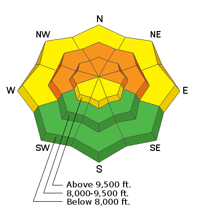
Each of these were soft slabs failing on the Jan/Feb drought layer Persistent Weak Layer (PWL) of facets. These soft slabs were generally 6-24" deep and up to 100' wide with aspects ranging from northwest to east-northeast and elevations from 7000' to just over 10,000'. Some of these were triggered at a distance. Many people were surprised by these avalanches but no one was reportedly caught or carried. Shooting cracks and audible "collapsing" or "whumphing" were noted by many of these backcountry parties. Some pics below.
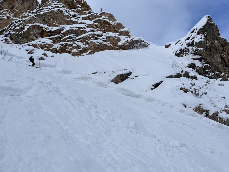
Neffs avalanche, Meadows/Dean
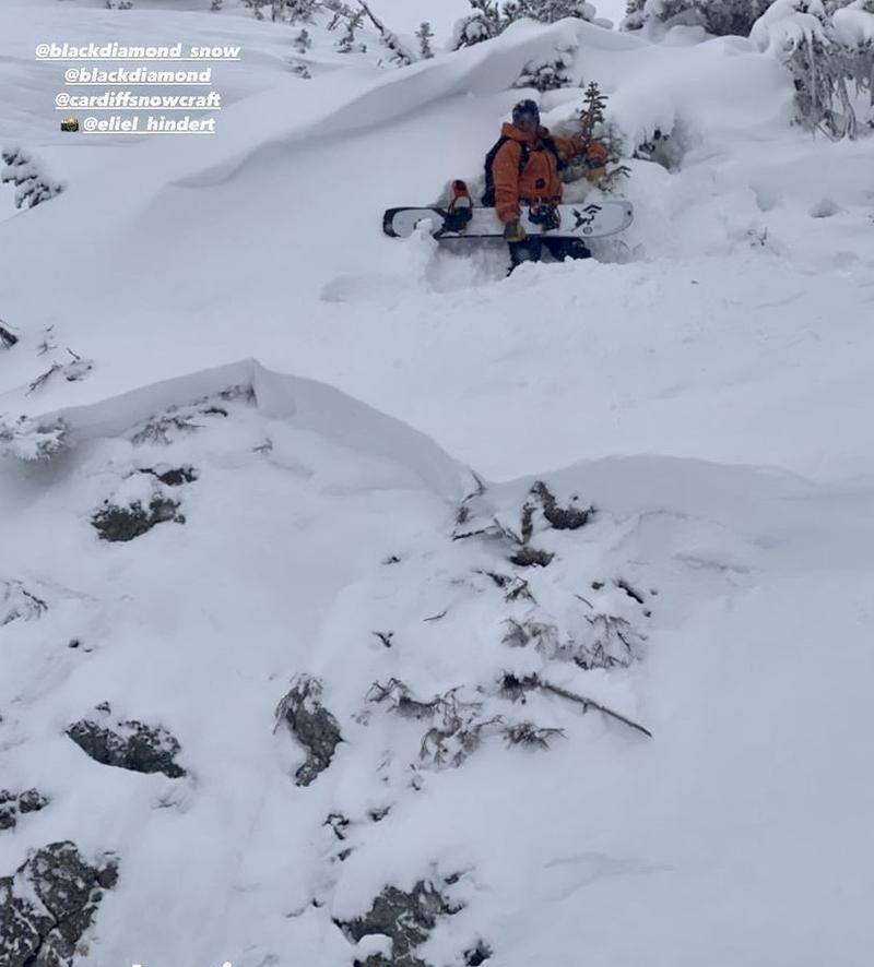
Brighton backcountry, Leines

Greg Gagne's Week in Review is published and can be found HERE.
By
Ad
Avalanche Problem #1
Persistent Weak Layer
Type
Location
Likelihood
Size
Description
There are booby-traps out there, friends.
The January/February drought resulted in very weak facets along the snow surfaces and it was clear that once it started snowing in earnest, we would have avalanches. The problem is that although it has snowed, it hasn't snowed in earnest, so that the avalanches, although widespread (pretty much all of the north part of the compass at all elevations) are relatively small and pockety. But relatively small and pockety can still kill you, especially if you're hungry for powder and especially if you're surprised by the avalanche, which is common whenever avalanches can be triggered at a distance.
The weak snow is easy to find. The issue is that the overlying slabs of cohesive snow are not as easy. Many slopes just have powder on facets while many others have powder snow that hides a slab below. Bruce Tremper used to call this "sucker snow". Which are which? Cracking and collapsing often accompany the existence of poor structure and avalanche conditions, but not always. My observation in Broads Fork yesterday looks at this more in depth HERE.
What to Do?
  • If the game is rigged, choose not to play. In other words, owing to the high uncertainty and the nature of the problem, choose low angle slopes with nothing steep above. We rode low angle northerly terrain yesterday and it was the best in two months.
  • Choose aspects that do not harbor the PWL: we know that northwest through east aspects harbor the PWL. West is uncertain and variable. Southwest to south to southeast do not harbor the PWL and these aspects will ride nearly as well today.
Avalanche Problem #2
New Snow
Type
Location
Likelihood
Size
Description
You can trigger loose snow avalanches in the steepest terrain today. These sluffs tend to move at your feet or machine and entrain more loose snow as it moves downhill. These sluffs can pile up deeply if they run in continuously steep and confined terrain.
General Announcements
Who's up for some free avalanche training? Get a refresher, become better prepared for an upcoming avalanche class, or just boost your skills. Go to https://learn.kbyg.org/ and scroll down to Step 2 for a series of interactive online avalanche courses produced by the UAC.
This information does not apply to developed ski areas or highways where avalanche control is normally done. This forecast is from the U.S.D.A. Forest Service, which is solely responsible for its content. This forecast describes general avalanche conditions and local variations always occur.