Fall Auction is now live! Check it out now

Forecast for the Moab Area Mountains

Eric Trenbeath
Issued by Eric Trenbeath on
Friday morning, February 18, 2022
The avalanche danger remains LOW on all aspects and elevations. Unstable areas of wind drifted snow may exist on isolated terrain features in upper elevation, wind exposed terrain.
Low
Moderate
Considerable
High
Extreme
Learn how to read the forecast here
Special Announcements
The Backountry 101 course has been canceled.
Road Conditions: The road to Geyser Pass Trailhead is mostly down to the dirt. Some patchy areas of packed snow and ice remain and they are slick. AWD and good tires are recommended.
Grooming: Trails have not been groomed since the recent snowfall. Follow LUNA (Lower Utah Nordic Alliance) on Instagram @luna_moab
Weather and Snow
6:00 a.m. weather data:
24 Hour Snow 0" 72 Hour Snow 2" Base Depth at Gold Basin 41" Wind NW 5-15 Temp 10F
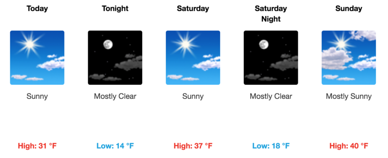
Dry sunny conditions and steadily warming temperatures are in store for the weekend. A much anticipated change in the weather pattern begins on Monday as a deepening trough begins to drop down over the region. Several bands of precipitation are expected to move through the state through midweek with Wednesday currently looking like the wettest for southern Utah. Do your rain dance, praise Ullr, or burn some skis and let's hope this winter turns back around before spring!
NWS Weather Forecast for the La Sal Mountains
Gold Basin SNOTEL site (10,000')
Storm Totals in Gold Basin
Wind Station on Pre Laurel Peak (11,700')
Snowpack
2" of low density snow fell on Wednesday. Wednesday night, NW winds blew in the 25-35 mph range with gusts to 50. As a result, we may see a few, thin wind slabs out there, particularly in higher, more wind exposed terrain, but in general our attention remains focused on the loose, sugary, faceted snow that has formed near the surface during this extended period of high pressure. These near surface facets will become the next weak layer in the snowpack and they are starting to get covered up.
The weakest snow can be found on shady, northerly aspects right around treeline and below. In some of these areas, the entire snowpack has become loose and faceted. Above treeline, conditions are much more variable ranging from from wind scoured and sun crusted, to boiler plate. Where crusts are thin, the snow is faceting underneath. This makes mapping of this future weak layer tricky. Generally speaking, the more sheltered the area, the more likely the the surface is to be weak and faceted. When new snow finally comes, slope by slope analysis will be required when getting into steep terrain.
Ad
Avalanche Problem #1
Normal Caution
Type
Location
Likelihood
Size
Description
Though the avalanche danger is low and generally stable conditions exist, here are some things to keep in mind:
  • Isolated, unstable areas of wind drifted snow may exist on the leeward sides of ridge crests and terrain features such as sub-ridges and rock outcroppings above treeline. Shallow wind slabs shouldn't pose much of a threat but one could sweep you of your feet and carry you over a cliff, especially if you are stomping around in higher, more extreme terrain. Be wary of smooth rounded deposits, or areas where the snow feels or sounds hollow underneath.
  • As the snow surface continues to weaken we'll start to see loose snow sluffs in steep terrain. These small slides generally won't pose much of a threat but they could sweep you off your feet and carry you over a cliff so be mindful of your exposure.
  • Areas of very firm snow exist where a fall could produce a dangerous, slide for life. Be mindful of your exposure on steep slopes with firm snow, and consider carrying a tool for self arrest in the high country.
General Announcements
Who's up for some free avalanche training? Get a refresher, become better prepared for an upcoming avalanche class, or just boost your skills. Go to https://learn.kbyg.org/ and scroll down to Step 2 for a series of interactive online avalanche courses produced by the UAC.
This forecast is from the U.S. Forest Service, which is solely responsible for its content. This forecast describes general avalanche conditions and local variations always occur.