We will be holding a Backcountry 101 course Feb 18, 19. It's a great introduction to understanding avalanche hazard and how to travel through the mountains safely.
Go here for details and to register. And a huge thanks to our friends at
Moab Gear Trader for their sponsorship of this course!
Road Conditions: The road to Geyser Pass Trailhead is mostly down to the dirt. Some patchy areas of packed snow and ice remain and they are slick. AWD and good tires are recommended.
Grooming: Trails have not been groomed this week. Follow LUNA (Lower Utah Nordic Alliance) on Instagram @luna_moab
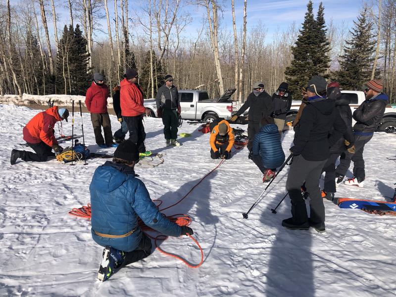
Members of the Grand County Winter Rescue Team turned out for ropes and toboggan training at the Geyser Pass Trailhead on Saturday. This solid crew is a great asset to our winter backcountry community. Thanks team!
6:00 a.m. weather data:
24 Hour Snow 0" 72 Hour Snow 0" Base Depth at Gold Basin 39" Wind SW 5-10 Temp 19F
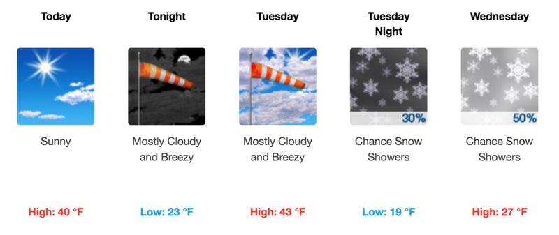
Another warm and sunny day on tap. We'll see clouds and increasing southerly winds tonight and into tomorrow as a closed low pressure system begins to drop southward through the Great Basin. By Tuesday night, the low will split from the main upper level trough and it appears that it will dive to the south of us. Wednesday will be our best chance for snow with maybe a few inches possible.
Snowpack
I'm not sure what you'd call it but Mark Sevenoff and I found decent turning conditions on a southerly aspect around 11,000' on Saturday. I guess faux-corn would be the best descriptor as it was certainly a melt freeze product. Elsewhere, conditions remain pretty rugged with a full range of crusts, textured surfaces, and hard snow. Areas with soft, re-crystallized "powder" can be found in sheltered areas but they are hit and miss to say the least.
During extended periods of high pressure we keep a vigilant eye on the development of loose, sugary,
faceted snow forming near the surface. Near surface facets can become the next weak layer in the snowpack when new snow lands on top. This weak, sugary, non-cohesive layer can also produce dry
loose snow avalanches. The weakest snow can be found on steep, shady, northerly aspects right around treeline and below. A group I spoke with on Saturday said the entire snowpack had become faceted in one such area they encountered. Above treeline, conditions are much more variable ranging from from wind scoured and sun crusted, to boiler plate. Where crusts are thin, the snow is faceting underneath. This makes mapping of this future weak layer tricky. Generally speaking, the more sheltered the area, the more likely the the surface is to be weak and faceted. When new snow finally comes, slope by slope analysis will be required when getting into steep terrain.