Fall Auction is now live! Check it out now

Forecast for the Moab Area Mountains

Eric Trenbeath
Issued by Eric Trenbeath on
Friday morning, January 14, 2022
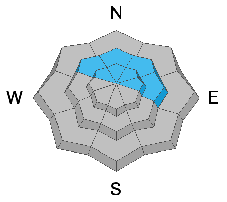
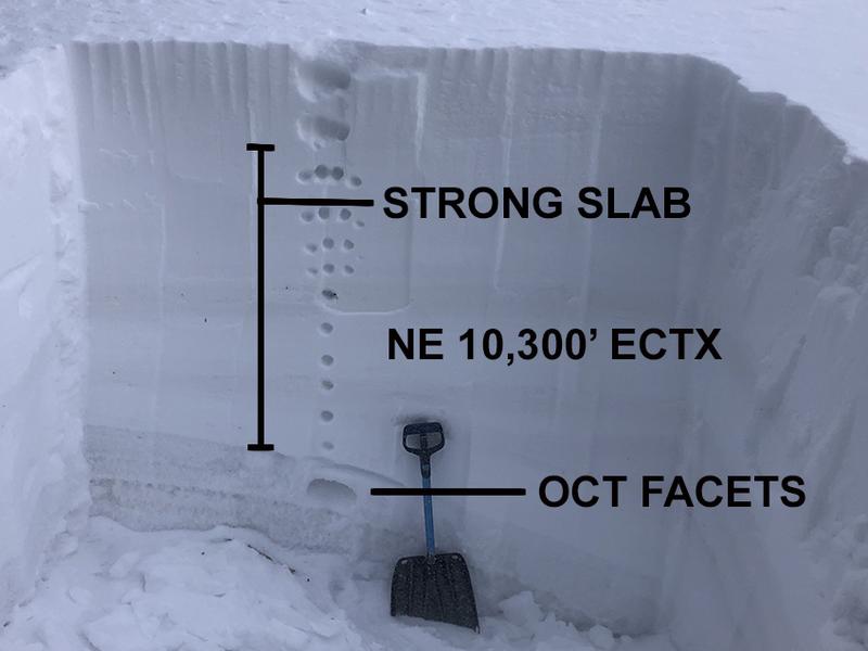
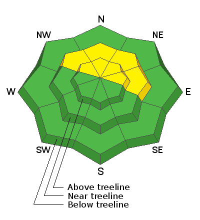
The avalanche danger remains MODERATE on steep slopes facing NW through E near and above treeline where it is still possible to trigger a large, deep, and very dangerous hard slab avalanche failing on a buried persistent weak layer.
Though the likelihood of triggering a deep and dangerous avalanche continues to trend downward, an avalanche of this magnitude would be un-survivable. Likely trigger points include thin, rocky areas and slopes with steep convexities.
Low
Moderate
Considerable
High
Extreme
Learn how to read the forecast here
Special Announcements
The beacon training park is up and running above the Geyser Pass Trailhead. Pull out your beacon and practice your skills as you head up the trail! A huge thanks to Moab Gear Trader for their support of this great resource!
Road Conditions: The road to Geyser Pass Trailhead is plowed but snow packed. AWD and good tires are recommended.
Grooming: Trails were last groomed on Wednesday.
Weather and Snow
24 Hour Snow 0" 72 Hour Snow 0" Base Depth in Gold Basin 40" Wind NW 25-30 Temp 22F
Gold Basin SNOTEL site (10,000')
Storm Totals in Gold Basin
Wind Station on Pre Laurel Peak (11,700')
NWS Weather Forecast
NW winds began to ramp up around 5:00 a.m. this morning as a shortwave trough passes by to our north. Today look for sunny skies, cooler temperatures, and blustery NW winds. Dry conditions continue into next early next week with nothing significant on the horizon.
Snowpack
How to liven up the discussion? Though the odds of triggering a large avalanche continue to decrease, a persistent weak layer of faceted snow still exists at the base of the snow pack on northerly aspects. Observations sent in over the past week indicate that this weak layer is gaining strength in some areas, while I have found it to still be dry, loose, and sugary in others. It's called spatial variability, and Charlie Ramser describes it well in his recent observation. Wind loading and wind stripping create varying depths across the snow pack. Deeper areas tend to be stronger, while shallower areas tend to be weaker. In thinner snowpack areas, the buried weak layer is also more easily affected by the weight of a skier or rider. This is why we say likely trigger points include thinner snowpack areas such as the lines along slope margins, near rocky outcrops, steep convexities, or on slopes that have previously avalanched. Careful terrain choices are imperative if you are considering stepping out. We are moving into a low probability, but high consequence situation and all it takes is finding the right trigger point.
We took a trip up into the high country in Gold Basin on Thursday. See video report below.
Recent Avalanches
No new avalanches have been reported since the Dec 31 avalanche cycle. Go here for the complete list.
Ad
Avalanche Problem #1
Persistent Weak Layer
Type
Location
Likelihood
Size
Description
A persistent weak layer of of sugary, faceted snow exists at the base of the snow pack and dense slab 3'-6' thick is sitting on top. Time, warmer temperatures, and compression from the load are helping to heal this weak layer, and snow pits and stability tests performed by myself and local observers indicate that it is gaining strength. Generally speaking, the deeper the snowpack, the stronger it is. This weak layer still remains a concern in areas where the snowpack is thin, and therefore much more easily affected by the weight of a skier or rider.
Photo illustrates strong slab over weak, October facets. Extended column tests produced no results and it's becoming harder for the weight of a skier or rider to affect this basal weak layer. Propagation saw tests however show that it is still possible for a slab to fail and propagate. Shallower snowpack areas are likely trigger points.
General Announcements
Who's up for some free avalanche training? Get a refresher, become better prepared for an upcoming avalanche class, or just boost your skills. Go to https://learn.kbyg.org/ and scroll down to Step 2 for a series of interactive online avalanche courses produced by the UAC.
This forecast is from the U.S. Forest Service, which is solely responsible for its content. This forecast describes general avalanche conditions and local variations always occur.