March Kicks Off Our Spring Campaign- Donate Now to Support Forecasting

Forecast for the Uintas Area Mountains

Mark Staples
Issued by Mark Staples on
Friday morning, January 7, 2022
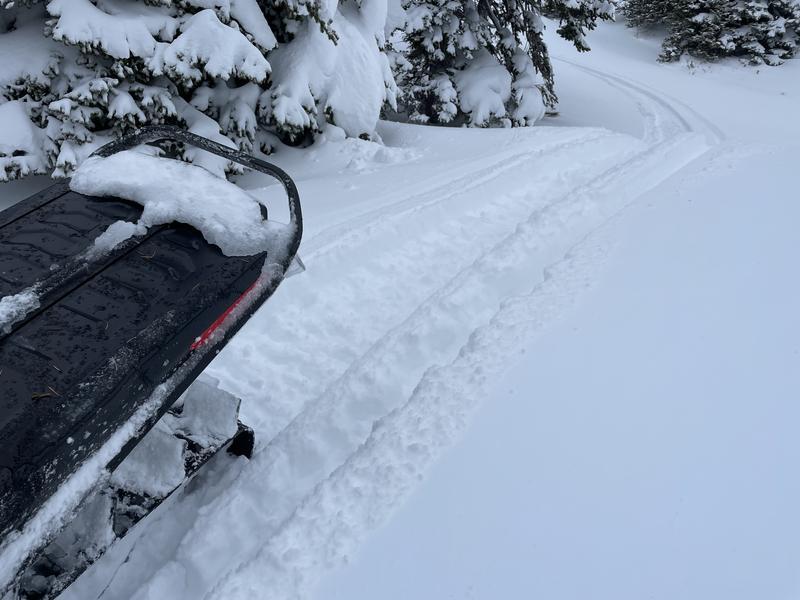
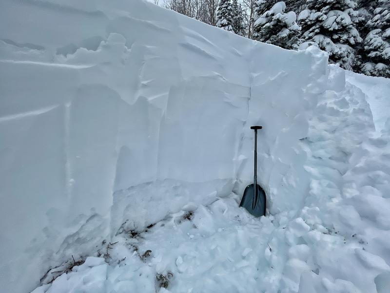
With so much heavy snow and wind-drifted snow, conditions remain dangerous on slopes that have either a buried persistent weak layer of facets near the ground or have recently wind drifted snow or both. On slopes facing northwest through northeast as well as east and southeast, the avalanche danger today is CONSIDERABLE near and above treeline. All other slopes have a MODERATE danger.

Where to go? With such excellent coverage, there are many terrain options with less dangerous conditions. Low angle slopes (ones less than 30 degrees in steepness) are always a great option because they are not steep enough to slide. South-facing slopes without wind drifted snow are a great option as well because they don't have a weak layer near the ground.
HEADS UP for roof avalanches - Many cabins have a lot of snow on the roofs which has started to slide off with warm temperatures. There have been people killed from roof avalanches. Pleases be especially watchful of children and don't let them play near the edges of roofs if you will be visiting a cabin this weekend.
Low
Moderate
Considerable
High
Extreme
Learn how to read the forecast here
Special Announcements
Introduction to Avalanche Rescue Course for the Uinta Region, on Wednesday, January 12th at Nobletts Trailhead. This course is based on snow, practicing with your rescue equipment learning how to rescue a buried partner. With a small student to instructor ratios, we make sure that each student receives individual coaching and feedback on their technique and the opportunity to run through multiple scenarios. Register HERE
Weather and Snow
NOWCAST-
Skies mostly cleared overnight after yesterday's cloudy/foggy conditions in the mountains. Temperatures this morning are generally in the mid 20s F, a little colder on the peaks and a little closer to freezing at trailheads. Winds at most upper elevation weather stations are blowing 14-26 mph from the south gusting to 35 mph. Wednesday's storm delivered 8-10 inches of very dense snow (containing 1.0-1.6 inches of water) with winds blowing 60-80 mph from the west and southwest.
FORECAST-
A short-lived ridge of high pressure will bring mostly sunny skies this morning and temperatures climbing to near freezing. By late afternoon an approaching trough of low pressure will cause winds from the south to increase again blowing 40 mph on upper elevation ridgetops. Clouds will increase and 2-3 inches of snow should fall tonight.
FUTURECAST-
Cold air descends over the area Saturday morning when clouds will start to clear and make way for sunshine by Saturday afternoon. The weather will be warm and sunny for Sunday and most of next week with a chance of snow maybe Thursday, but no major storms are in the forecast.
All the heavy snow has made very supportable riding conditions but the snow remains very soft and fun. The photo below is from yesterday afternoon near Moffit Peak in upper Weber Canyon. The snow became very wet yesterday at low elevations. Fortunately, the Uintas have a lot of higher elevation terrain where the snow remains dry.

Looking for real-time temps, snow, or wind?
Click HERE and then on the "western Uinta" tab for western Uinta specific, weather station network.
Recent Avalanches
No avalanches were reported yesterday in the Uinta Mountains; however, visibility was poor and few people were out. There were several large avalanches in the Wasatch Range which has a similar or stronger snowpack, so it's fair to assume Wednesday's very heavy snow caused at least few large slides in the Uintas.

Click HERE for a list of recent avalanches.
A list of all other observations is found HERE

Your input is vital and we're interested in what you're seeing. Please contribute to this great community resource and go here to fill out an observation.
Ad
Avalanche Problem #1
Persistent Weak Layer
Type
Location
Likelihood
Size
Description
There is a persistent weak layer of faceted, old, rotten snow near the ground mostly on north-facing slopes. Very large, hard slab avalanches have been breaking on this layer. Wednesday's heavy load of snow has stressed this layer again, and I wouldn't trust any slope facing north. At upper elevations, even west and southeast facing slopes may have this layer that can produce avalanches.
All of the snow since Christmas has been a good thing that will heal this weak layer, HOWEVER, it doesn't heal overnight. For now what makes this layer dangerous is:
  • Once triggered, avalanches may break hundreds of feet wide.
  • Avalanches will be 3-5 feet deep.
  • It may not be the first person on a slope that triggers A LARGE, DANGEROUS avalanche, it may be the second, third, fourth, etc. who triggers it.
  • Seeing tracks on a slope DOES NOT mean it's safe.
Here's the good news - This layer doesn't exist on south facing slopes which have excellent coverage, and soft creamy powder.
Photo - Northeast facing slope at 9600 feet showing the weak snow near the ground which looks sugary and granular.
Photo - An example of the snowpack on an east facing slope that doesn't have the weak layer. The snowpack is just strong and right-side-up, meaning it's hard at the ground and gets softer near the top. Low elevation east facing slopes generally don't have the weak layer however we have been finding it on east aspects as you gain elevation.
Avalanche Problem #2
Wind Drifted Snow
Type
Location
Likelihood
Size
Description
Strong winds from the west and southwest have formed slabs of wind drifted snow along upper elevation ridgelines. These drifts can begin stabilizing; however, what they do is add A LOT of extra weight and stress to the buried PWL discussed above making avalanches on that layer more likely.
The simple answer today is to ride slopes with the best powder that haven't been affected by recent winds.
Avalanche Problem #3
New Snow
Type
Location
Likelihood
Size
Description
The new snow from Wednesday's storm has quickly bonded to itself and the old snow surface under it, and I think the odds of triggering a soft slab avalanche of the new snow alone are very small.
Additional Information
We installed the Transceiver Check station at Nobletts Trailhead this week... it's up and running and good to go. Of course, you want to check your partner before leaving the parking lot, but this is a good fail safe system to make sure everyone is sending a signal.
Your observations are important, so please let me know what you're seeing... click HERE and contribute to this amazing community based program
General Announcements
The information in this forecast expires 24 hours after the day and time posted, but will be updated by 07:00 Friday January 7th.
Before it gets too crazy, now is the time to book an avalanche awareness presentation for your group, club, or posse. You can reach me directly at 801-231-2170 or [email protected]
This forecast is from the U.S.D.A. Forest Service, which is solely responsible for its content. This forecast describes general avalanche conditions and local variations always occur.