Forecast for the Moab Area Mountains

Issued by Eric Trenbeath on
Thursday morning, December 23, 2021
Thursday morning, December 23, 2021
Expect a rising avalanche danger over the next several days!
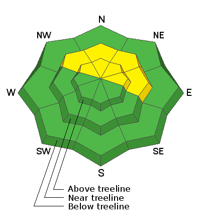
A MODERATE avalanche danger exists on steep slopes that face NW through E where a dense slab 2'-3' thick exists on top of a persistent weak layer of sugary faceted snow. Human triggered avalanches are possible in these areas. The danger increases with elevation where deposits of wind drifted snow have added additional stress to the underlying, weak snowpack structure.
Most low elevation and south facing terrain has a generally LOW danger.
It's also still very low tide out there. Beware of rocks, stumps, and deadfall lurking beneath the surface.

Low
Moderate
Considerable
High
Extreme
Learn how to read the forecast here
 Special Announcements
Road Conditions: The road is snowpacked and slick and AWD vehicles with good tires are recommended.
Grooming: LUNA (Lower Utah Nordic Alliance) groomed all trails on Monday. Follow them on Instagram @luna_moab. Thanks Matt!
 Weather and Snow
24 Hour Snow 0" 72 Hour Snow 0" Base Depth in Gold Basin 22" Wind S 15-25 G35 Temp 32F
Southerly winds have begun to ramp up ahead of an atmospheric river setting up off the west coast. This potent system, while poised to deliver multiple feet to the Sierra, looks like it will manifest in the form of a decent storm for us. Snow should develop tonight and continue into Friday with the highest snowfall rates early in the early morning hours. 8"-14" seem likely at this time. Showers linger through Friday with a break on Saturday before the next system moves in on Sunday. An active pattern remains in place through next week.
Snowpack
The snowpack has become pretty quiet over the past week. Dave Garcia and Nate Ament were out stomping around Gold Basin yesterday and they did not observe any outward signs of instability such as cracking or collapsing, and their stability tests produced no results. Read their complete observation here. Nevertheless, a poor snowpack structure still exists on northerly facing terrain where a dense slab of snow 2'-3' thick exists on top of loose, sugary, facets. Good terrain choices are key and steep convexities, or shallow rocky areas are likely trigger points. Persistent weak layer problems are difficult to manage and any avalanche triggered would be deep and dangerous. With storms moving in we will have to be alert to a "re-awakening" of this buried, persistent weak layer as the additional weight of new and wind drifted snow accumulates.
Overall snow cover remains quite thin but soft, settled powder over a supportable base can still be found in sheltered areas. Sun and wind exposed slopes are pretty hammered, and rocks, stumps, and deadfall continue to pose hazards.
Weather Links
Gold Basin SNOTEL site (10,000')
Wind Station on Pre Laurel Peak (11,700')
NWS Weather Forecast
 Recent Avalanches
No new avalanches have been reported since last week's storm event. Here is the current avalanche list.
Avalanche Problem #1
Persistent Weak Layer
Type
Location

Likelihood
Size
Description
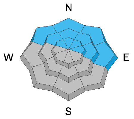
A dense, cohesive slab 2'-3' thick exists on a persistent weak layer of loose, sugary facets that formed in the October snow. Slabs have grown increasingly stubborn to release but an avalanche triggered on this persistent weak layer would be deep and dangerous. This problem exists on all steep, northerly facing terrain that has held snow since October and the danger increases with elevation. This problem is difficult to manage and the only sure way is to avoid these areas. If you do venture on to steeper, northerly facing terrain, you can reduce your risk by avoiding steep convexities, or shallow rocky areas in starting zones or along slope margins.
Additional Information
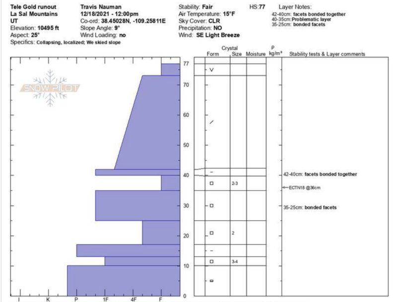
And for you snow geeks out there. Check out this snowpit from Travis Nauman. Picture it as building blocks as it illustrates hard or denser layers over weak layers. The further a layer is shown stretching out to the left, the harder it is. The weak layer of concern is between 35-40 cms. Thanks Travis!

General Announcements
Who's up for some free avalanche training? Get a refresher, become better prepared for an upcoming avalanche class, or just boost your skills. Go to https://learn.kbyg.org/ and scroll down to Step 2 for a series of interactive online avalanche courses produced by the UAC.
This forecast is from the U.S. Forest Service, which is solely responsible for its content. This forecast describes general avalanche conditions and local variations always occur.


