Join us for the 17th Annual Professional Snow and Avalanche Workshop (PROSAW) on November 4 - Purchase tickets here!

Forecast for the Salt Lake Area Mountains

Nikki Champion
Issued by Nikki Champion on
Wednesday morning, December 22, 2021
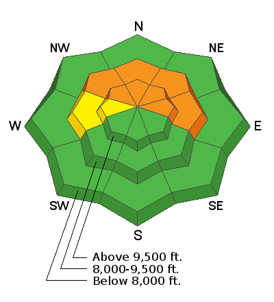
Today, the avalanche danger is CONSIDERABLE on steep slopes facing northwest, north, northeast, and east at the mid and upper elevations.
The avalanche danger is MODERATE on mid-elevation and upper elevation slopes facing west.
The remaining aspects and elevations have a LOW danger.

Large, deadly, and dangerous human-triggered avalanches 2-5' deep and hundreds of feet wide are likely. These avalanches can be triggered from a distance.

HEADS UP: With lots of wind & snow in the forecast, the avalanche danger will be on the rise starting Thursday and will continue to be dangerous through the holiday break. Please share the word with friends, family, and riding partners that conditions will continue to be dangerous and deadly here in Northern Utah, especially as the new snow stacks up. Be careful.
Low
Moderate
Considerable
High
Extreme
Learn how to read the forecast here
Weather and Snow
This morning, skies are partly cloudy, winds are light to moderate and there is a temperature inversion in the mountains. Currently, the mountain temperatures hover in the 20's °F at the mid and upper elevations. Down lower in the canyon and the valley bottoms, the temperatures hover in the mid-teens °F. The southwesterly winds have bumped up in speed overnight, with speeds of 15-25 mph, with the highest gusts hitting 50 mph across the upper ridgelines.
Today will be the final calm before the storm, with partially cloudy skies, and even periods of sunshine poking through this afternoon. Mountain temperatures will climb into the upper 20s °F and mid-30s °F. The southwesterly winds will remain elevated, blowing at speeds of 10-20 mph with the occasional upper ridgeline gust up to 50 mph.
Tonight, cloud cover will increase overnight and light snowfall should begin sometime after midnight. Snow totals should remain relatively low over the next 24 hrs, as the brunt of the storm and the heaviest snow will occur Thursday evening through late Thursday night. The snow density will then become lighter Friday as colder air moves in. While the entirety of the storm still feels a way out, below are some graphics from the National Weather Service showing some probabilistic snow totals for the first wave of the storm (12/22-12/26). Still impressive numbers so far, let's keep our fingers crossed!


There is still plenty of good riding to be found in the backcountry. Southerly slopes have begun to crust over with the multiple days of sunshine, but any shaded terrain still holds soft cold snow. With these past few cold-clear nights, the surface snow in protected, non-solar facing terrain has begun to facet and weaken. While this makes for fine riding conditions today, as the next storm moves into the area, the new snow may bond poorly to the old snow in these areas or become another weak layer in the future.
Recent Avalanches
No new avalanches were reported from the backcountry yesterday. However, within ski resorts, one patrol was able to get one notable hard slab avalanche to pull out to the ground with explosives. This avalanche was on an upper elevation Northeast facing convexity, and about 4-5' deep and 100' wide.
Reports of large booming collapses and poor snowpack structure continue to be observed by backcountry travelers.
Ad
Avalanche Problem #1
Persistent Weak Layer
Type
Location
Likelihood
Size
Description
Dangerous avalanche conditions still exist on mid and upper elevation slopes facing west through north through east where 2-3' of storm snow, and wind-blown snow has overloaded weak, faceted snow in the bottom of the snowpack. Avalanches may break down 2-5' deep (possibly deeper) and propagate hundreds of feet wide. While we haven't seen as many reports of the recent avalanche in the last day or two, backcountry travelers continue to get large booming collapses, and as soon as we dig into the snow we find a poor snowpack structure. These are two big red flags, that let us know we need to continue to give this problem time.
The good news: Travel advice remains simple, If you want to ride terrain on the northerly (shady) side of the compass, you must choose slopes under 30° degrees in steepness with nothing steep above you.
Video from yesterday, where Francine and I went a looked at a large recent avalanche off of the Park City Ridgeline. The poor snowpack structure remains obvious. As we move into the next storm system we will continue to overload and stress the weak faceted snow leading to more large and destructive avalanches. Check out the full observation HERE.
General Announcements
Who's up for some free avalanche training? Get a refresher, become better prepared for an upcoming avalanche class, or just boost your skills. Go to https://learn.kbyg.org/ and scroll down to Step 2 for a series of interactive online avalanche courses produced by the UAC.
This information does not apply to developed ski areas or highways where avalanche control is normally done. This forecast is from the U.S.D.A. Forest Service, which is solely responsible for its content. This forecast describes general avalanche conditions and local variations always occur.