Join us at our 2nd Annual Blizzard Ball

Forecast for the Moab Area Mountains

Eric Trenbeath
Issued by Eric Trenbeath on
Thursday morning, December 16, 2021
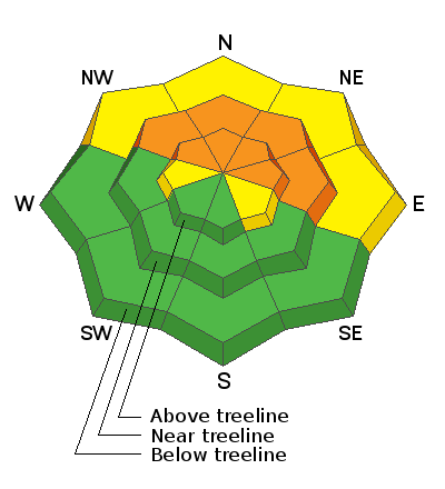
Blowing and drifting snow has kept the avalanche danger at CONSIDERABLE on steep, mid to upper elevation terrain that faces NW through E and human triggered soft slab avalanches, up to 2' deep failing on a buried persistent weak layer are likely in these areas.
The avalanche danger is MODERATE on low elevation, northerly facing slopes, and on W and SE aspects where you can detect recent deposits of wind drifted snow.
Coverage remains quite thin. Beware of lingering obstacles such as rocks, stumps and deadfall just below the surface.
Low
Moderate
Considerable
High
Extreme
Learn how to read the forecast here
Special Announcements
Road Conditions: Grand County plowed on Wednesday. The road is snowpacked and AWD with good tires recommended.
Grooming: Groomers will be up today training and eventually packing things out.
Batteries for Beacons runs through Dec 19. Get free batteries for your transceiver and a chance to win 1 of 10 Black Diamond Rescue Kits, 1 of 3 Mammut Barryvox transceivers, or 1 of 3 BCA Tracker transceivers. Stop in at Moab Gear Trader, fill out our survey and get a free set of batteries. Don't need batteries, but still want a chance to win? Simply fill out the survey to be registered.
I was recently interviewed by Peggy Hodgkins for Science Moab. You can listen to the podcast: The Art of Avalanche Forecasting here.
Weather and Snow
24 Hour Snow 0" 72 Hour Snow 4" Base Depth in Gold Basin 23" Wind S 10-20 G30 Temp 15F
After a brief respite yesterday afternoon, southerly winds are again on the increase this morning. Today look for mostly sunny skies, breezy SW winds, and high temps near 20F. We should see developing high clouds later today with mostly cloudy conditiond and a slight chance for snow showers tonight as a system tracks through to the north. The weekend will be be dry and sunny with seasonal high temps in the lower 20's. Models are hinting at the next system mid next week.
I'm afraid wind and not new snow has been the primary factor affecting the snowpack over the past several days. Reports from the backcountry this week indicate continued dangerous conditions from blowing and drifting snow and poor snow pack structure and collapsing and whumphing are still being observed. I'm thinking that instabilities have to be settling out somewhat by now, but it's early season and until I get a clearer picture of what's going on out there the snowpack will be considered guilty until proven innocent. I'll be getting up today to have a look around.
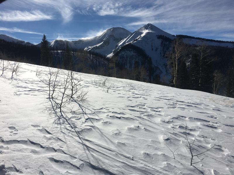
Winds have scoured all exposed surfaces while depositing fresh drifts onto leeward slopes. Note the plumes of blowing snow on the high ridge tops in the background. Photo courtesy of Charlie Ramser.
Weather Links
Gold Basin SNOTEL site (10,000')
Recent Avalanches
No new avalanches have been reported since last week's storm event. Here is the current avalanche list.
Ad
Avalanche Problem #1
Persistent Weak Layer
Type
Location
Likelihood
Size
Description
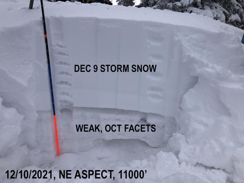
And so it begins. Snow that has been sitting around on the ground since October has become weak and faceted, and a dense, soft slab up to 2' thick is sitting on top. This condition exists on slopes facing NW through E and will likely pose a persistent weak layer problem for the foreseeable future. Southerly winds throughout the week have continued to drift additional snow on to these aspects thereby increasing the load on this fragile snowpack structure. Human triggered avalanches remain likely in these areas.
Avalanche Problem #2
Wind Drifted Snow
Type
Location
Likelihood
Size
Description
Strong southerly winds over the past several days have continued to blow and drift snow on to northerly aspects where weak, sugary snow from October sits underneath. This incremental wind loading has slowly been adding additional stress to pre-existing slabs that are sitting on top of the October, persistent weak layer. The strategy for now remains simple - avoid steep slopes facing NW through E, as well as any area where you can detect recent deposits of wind drifted snow.
General Announcements
This forecast is from the U.S. Forest Service, which is solely responsible for its content. This forecast describes general avalanche conditions and local variations always occur.