Check out our Holiday Auction - Sign Up for the Utah Snow and Avalanche Workshop (USAW)

Forecast for the Salt Lake Area Mountains

Nikki Champion
Issued by Nikki Champion on
Thursday morning, December 16, 2021
Today, we have a CONSIDERABLE avalanche danger on all steep mid and upper elevation slopes facing west through north through east where fresh wind drifts and new snow sit atop of the weak faceted snow. There is a MODERATE danger on southerly upper and mid-elevation slopes, and low elevation slopes facing west through north through east. Stay off of and out from underneath slopes 30° degrees and steeper at the mid and upper elevations. If you trigger an avalanche, it is likely to break down 2-4' and up to several hundred feet wide.
The remaining aspects and elevations have a LOW danger.
There are two primary avalanche problems to watch for: (1) triggering a slab avalanche 2-4' deep in the weak faceted snow, (2) soft slabs of new or wind drifted snow that would likely steep down into the weak snow below.
Low
Moderate
Considerable
High
Extreme
Learn how to read the forecast here
Weather and Snow
Currently, skies are overcast and it has begun lightly snowing in the mountains. Mountain temperatures are in the low to mid-teens °F. Winds remain elevated from the Southwest blowing at speeds of 15-30 mph, with gusts up to 35 mph at mid-elevations. At upper elevation ridglines, the winds are howling, blowing at speeds of 40-50 mph, with gusts up above 80 mph. No new snowfall has begun accumulating yet this morning, but there is still soft settled powder in the mountains and riding conditions have greatly improved.
Before the break, yesterday's snowfall totals ended at:
Little Cottonwood Canyon: 18-23" (1.5-2.0 " H2O)
Big Cottonwood Canyon: 13-17" (1.24-1.41" H2O)
Park City Ridgeline: 7-13" (1.0-1.2" H2O)
Today, we can expect skies to remain overcast and temperatures to climb into the upper teens and low 20s°F. We should see periods of light snowfall this morning, and an increase in snowfall intensity this afternoon as a weak cold front pushes through the area. Throughout the day we could see another 5-9" of snow, before tapering off into light showers this evening. Winds will remain elevated and transition to more Westerly. At mid-elevations winds will average 15-25 mph, with gusts up to 35 mph. At upper-elevation ridgelines winds will blow 20-30 mph, with gusts up to 65 mph.
Recent Avalanches
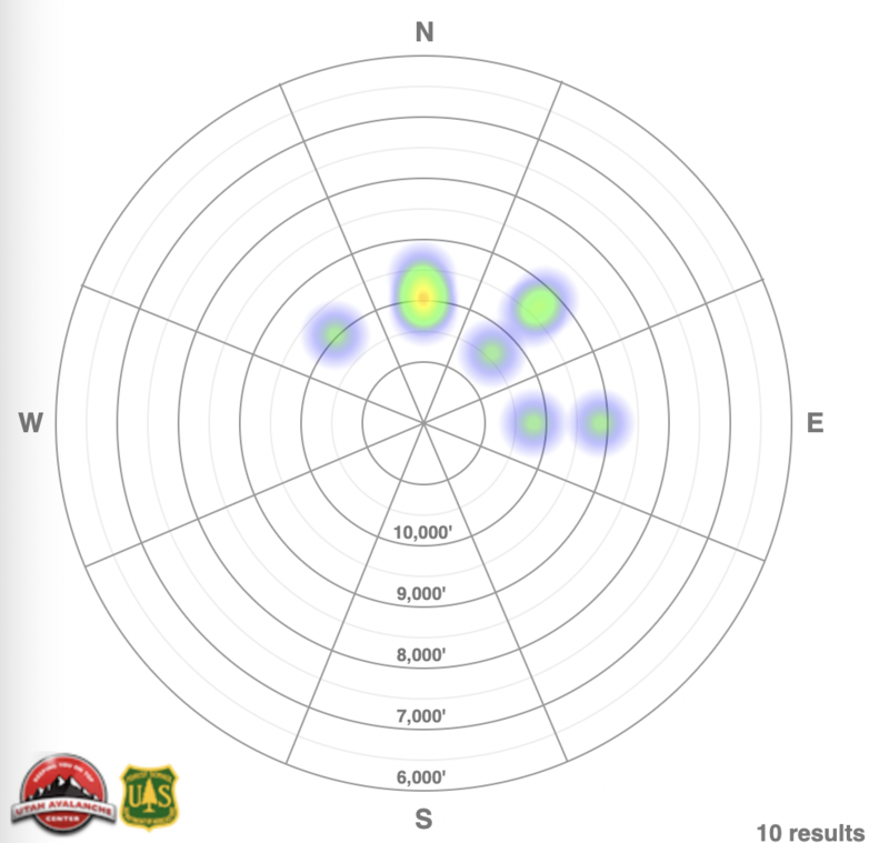
Yesterday was an active day both in the backcountry as well as ski resorts. Ski areas were reporting active results with explosives as well as some natural cycles during the peak of the storm, primarily in mid and upper elevation north facing terrain. In the backcountry, 10 new avalanches were reported. All of these avalanches were in the west to north to east facing mid and upper elevation terrain and triggered either within the new storm snow or down to the faceted snow as a soft slab. Many of these avalanches were remotely triggered from a distance.
Heat map of central Wasatch backcountry avalanche activity from yesterday.
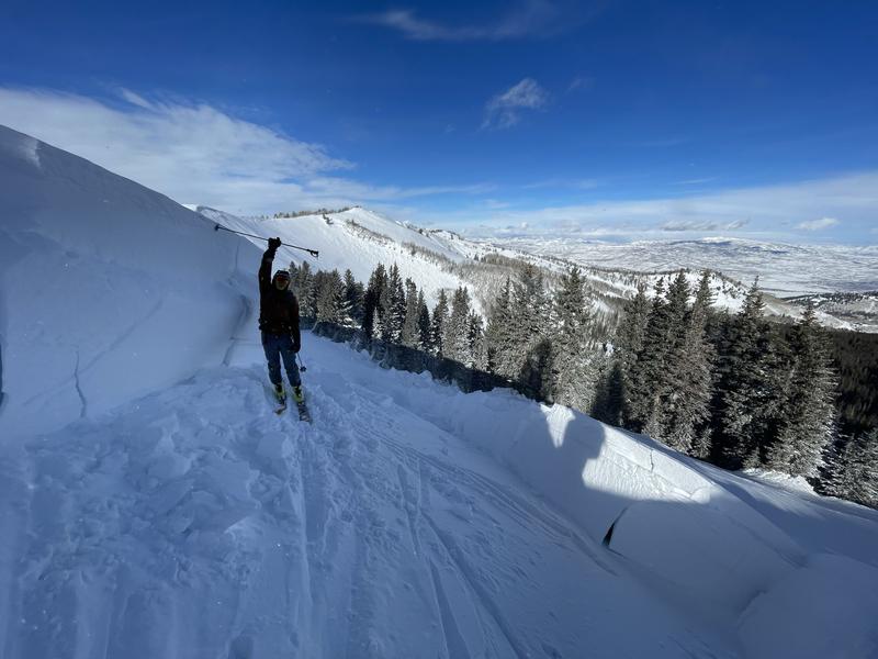
One avalanche from yesterday, from the Park City Ridgeline in an area known as Katie's, was remotely triggered from the Ridgeline and broke down 3' on facets sitting atop a crust. While the crown was primarily 3' deep, this area was heavily windloaded, and had crown depths up to 8'. This is a reminder that any slopes that area currently wind-loaded, are likely to break more deeply onto that weak faceted snow.
Photo showing the deepest part of the crown where the slope was heavily wind loaded. Katies, Park City Ridgeline, UT. (Z. Little)
You can find all backcountry observations HERE.
Ad
Avalanche Problem #1
Persistent Weak Layer
Type
Location
Likelihood
Size
Description
Most of the avalanches we've seen over the past few days have been soft slab avalanches failing on a persistent weak layer on the Northern end of the compass. With every bump in wind speed and or new snowfall event added to our fragile snowpack, we continue to wait for the weak facets to become unglued. Yesterday we added two huge new stressors to this fragile snowpack in the form of new snowfall and elevated winds. While we didn't see things become fully unglued, we saw 10 new avalanches in the backcountry yesterday and we know that human triggered avalanches will still be likely today.
Given the new snowfall, elevated winds, and poor snowpack structure I would avoid any west through north through east facing terrain steeper than 30 degrees, with any steep terrain above or attached to it. Today is not the day to push it. This persistent weak layer is not going anywhere fast, and the best way to handle it is avoidance. Stick to low-angle terrain.
The good news: With yesterday's new snowfall, the riding conditions have greatly improved on all aspects. While southerly aspects are still thin, as many where stripped bare before the snowfall. It does give us an option to ride without the weak faceted snow. So if you are going out today, slope angle and aspect are going to be the name of the game.
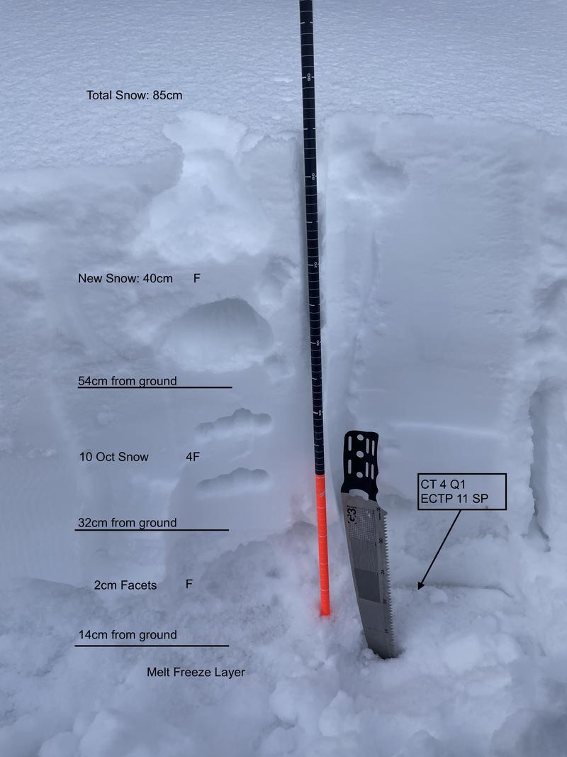
See the obvious facets on the ground, and poor snowpack structure from the Park City Ridgeline yesterday (C. Brackelsberg)
Avalanche Problem #2
Wind Drifted Snow
Type
Location
Likelihood
Size
Description
The winds have been cranking all week, and continue to remain elevated. Hidden Peak is gusting above 80 mph this morning. High winds in combination with the new snow will continue to form both soft and hard slabs at all mid and upper elevations. As the winds continue to blow, these slabs will become more firm and cohesive. This can allow you to travel out farther onto the slope before it breaks, and can fail larger and wider than expected. Look for any obvious signs of wind drifted snow, such as hollow sounding or pillow-shaped snow, and avoide those slopes.
High winds can deposit snow on all aspects but give west through north through east extra caution, as triggering an avalanche that initially fails in the wind-drifted snow will likely break down more deeply into the weak faceted snow below.
In any wind-sheltered areas, some new soft snow may still be found. In those areas, you may find still find some lingering fast-running sluffs or sensitive storm slabs. Look for signs of new snow instabilities such as cracking, and collapsing. Triggering an avalanche that initially fails in storm snow will also break down more deeply into the weak faceted snow.
General Announcements

This information does not apply to developed ski areas or highways where avalanche control is normally done. This forecast is from the U.S.D.A. Forest Service, which is solely responsible for its content. This forecast describes general avalanche conditions and local variations always occur.