Join us at our 2nd Annual Blizzard Ball

Forecast for the Salt Lake Area Mountains

Mark Staples
Issued by Mark Staples on
Wednesday morning, April 14, 2021
Today the avalanche danger is MODERATE at upper elevations as slabs of wind drifted snow form later today from south winds. Also, watch for sluffing of the new snow and possibly some soft slab avalanches of new snow. The danger at mid and lower elevations is LOW.
Low
Moderate
Considerable
High
Extreme
Learn how to read the forecast here
Special Announcements
Sunday, April 18th will be the 163rd avalanche forecast and the last one for the 2020/2021 season. For the rest of the month of April, we will provide updates on the snow and weather anytime it snows which is hopefully a lot. We will also continue to post observations.
Weather and Snow
This morning, it's windier in many valley locations than in the mountains where winds are blowing 10-20 mph gusting 30 mph from the east-southeast. Temperatures are generally in the mid 20s F. As of 5 a.m. only 1 inch of snow has fallen.
Today, a slow-moving storm will bring 5-9 inches of snow with more tonight and tomorrow. Some cold air will move into the area this afternoon and help keep temperatures cool. High temperatures today should be in the upper 20s to low 30s F. Winds will shift direction and blow from the south 10-20 mph. Gusts at the highest elevations will reach 55 mph.
Total snow accumulations by Friday morning should be 8-14 inches of snow (0.8-1.2 inches of water).
Recent Avalanches
No avalanches were reported yesterday. The snowpack remained frozen and hard.

As always, find all of our observations and recent avalanches HERE.
Ad
Avalanche Problem #1
Wind Drifted Snow
Type
Location
Likelihood
Size
Description
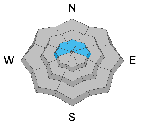
As new snow accumulates and is transported by south winds, expect to find fresh slabs of wind drifted snow. These wind slabs could be a foot deep by later this afternoon, and they will be the main avalanche issue to look for and avoid.
Avalanche Problem #2
New Snow
Type
Location
Likelihood
Size
Description
Instabilities in the new snow depend on how much falls, how it sticks to the old, hard, frozen snow surface, and how the new snow bonds to itself. By the end of the day, sluffs in the new snow will be possible but should be shallow.
I don't expect any soft slab avalanches in the new snow; HOWEVER, watch for cracking in the new snow, and any sign that it is becoming a soft, cohesive slab. A dramatic increase in snowfall rates with snow falling 1-2 inches per hour will also be a sign that soft slab avalanches in the new snow may happen.
Additional Information
General Announcements
Please visit this website with information about Responsible Winter Recreation by the Utah Office of Outdoor Recreation.

This information does not apply to developed ski areas or highways where avalanche control is normally done. This forecast is from the U.S.D.A. Forest Service, which is solely responsible for its content. This forecast describes general avalanche conditions and local variations always occur.