Join us at our 2nd Annual Blizzard Ball

Forecast for the Salt Lake Area Mountains

Trent Meisenheimer
Issued by Trent Meisenheimer on
Monday morning, March 15, 2021
Today the avalanche danger is MODERATE on all aspects at the mid and upper elevations for triggering a fresh slab of wind drifted snow. Look for and avoid steep slopes that have been recently loaded by the wind.

Remember that even a small avalanche can be problematic, especially in very steep and complicated terrain. Think about the terrain you are traveling above today. If it avalanches, where do you go?
It's spring, and the sun is strong; if for some reason the clouds give way to clear skies, be on the lookout for the snow surface becoming wet. Roller balls are the first sign of wet snow. Loose wet snow avalanches should always be on the mind this time of year.
Low
Moderate
Considerable
High
Extreme
Learn how to read the forecast here
Special Announcements
Four riders were boot packing up the east ridge of the Pfeifferhorn when a shallow 2-6 inch deep wind slab failed. All four people were caught and carried, and some suffered injuries. Link to a preliminary report can be found HERE. UAC staff will visit the site this morning and update the accident report in the next few days.
Weather and Snow
A trough off the coast of Northern California will continue to dig southward and become a closed low that tracks to the south of Utah and eventually crosses over Arizona tomorrow. Unfortunately, the moisture from this storm will be apart of a wrap-around feature that typically doesn't favor the Wasatch Range. We are likely to see a trace to a couple of inches of new snow later tonight into Tuesday. As this closed low moves eastward into New Mexico, a ridge builds into Northern Utah midweek leading to mild temps and passing clouds. A splitting storm sets up for the weekend, and as of now, the models show some decent snow Saturday through Monday. Stay tuned
Currently, under partly cloudy skies, the mountain temperatures range 20-25°F at the mid and upper elevations. Winds have finally relaxed and backed to the westerly direction and are currently blowing 10-15 mph with gusts into the low 20's at the upper elevations. It should remain partly cloudy this morning, with the possibility of some sun streaming through the clouds this afternoon before the clouds begin to thicken up once again later today. Temperatures will rise into the mid 30's °F this afternoon at 9,000'.

Our Week in Review - where we highlight significant avalanche and weather events from the past week has been published.
Recent Avalanches
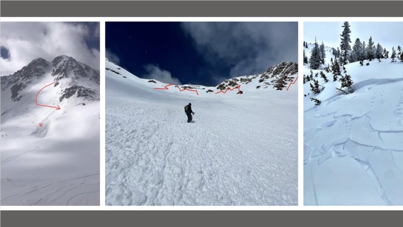
Yesterday was a very active day in the Wasatch Range, with 13 new avalanches reported to the UAC. Seven people were caught and carried in avalanches, and in one incident, people were injured. All of these avalanches were wind slabs caused by the strong winds over the past 36 hrs. Most of these wind slabs were 5-18 inches deep and up to 50 feet wide, except for the Pfeifferhorn avalanche being wider. These avalanches were found on all different aspects at the mid and upper elevations throughout the range.
Take a few minutes and scan through the avalanche list found HERE.
Ad
Avalanche Problem #1
Wind Drifted Snow
Type
Location
Likelihood
Size
Description
Over the past 36 hrs, the wind has blown from different directions at speeds of 20-30 mph with gusts into the 60's. The wind also blew from the east, creating drifts in unusual locations. New snow + wind = Avalanches. Today will be no different from yesterday, as lingering drifts of wind-blown snow will remain sensitive to the weight of humans.
It was a little surprising to me; that all the wind slabs triggered yesterday were in very exposed steep terrain where there was active wind loading happening. It's avalanche 101, the wind blows, and it creates avalanches. Yesterday, it should have been easy to visually see the wind drifting snow, AND it should have been easy to feel the thick/slabby/hollow snow as we traveled, AND it should have been easy to change and alter our plans based on this information. It's good to have objectives, but our plans need to change based on the snow, weather, and observations we make on our way to the objective.
Photos, left to right: (Lake Peak (Peter), Icefall (Blaster), Days Fork (Chasen))
General Announcements
Please visit this website with information about Responsible Winter Recreation by the Utah Office of Outdoor Recreation.

This information does not apply to developed ski areas or highways where avalanche control is normally done. This forecast is from the U.S.D.A. Forest Service, which is solely responsible for its content. This forecast describes general avalanche conditions and local variations always occur.