March Kicks Off Our Spring Campaign- Donate Now to Support Forecasting

Forecast for the Uintas Area Mountains

Craig Gordon
Issued by Craig Gordon on
Tuesday morning, March 9, 2021
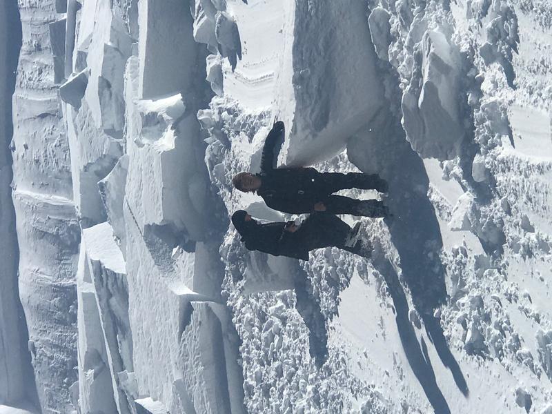
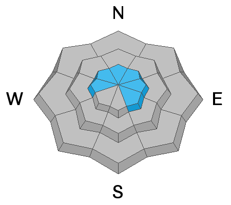
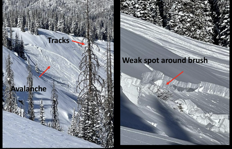
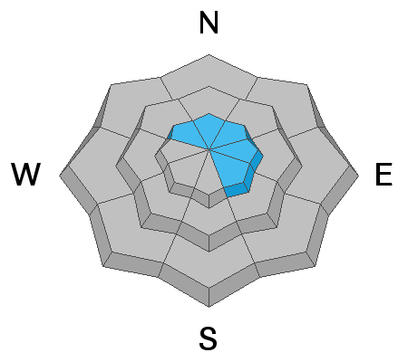
Today you'll find MODERATE avalanche danger above treeline in upper elevation terrain, especially on steep leeward slopes in the wind zone, facing the north half of the compass. Both old and new wind drifts will react to our additional weight and human triggered avalanches are POSSIBLE. While more the exception than the rule, any avalanche that breaks to weak layers of snow near the ground will result in a deep, dangerous avalanche that'll instantly ruin your day.

Southerly slopes, along with wind sheltered, shady, mid and low elevation terrain offers generally LOW avalanche danger. Remember- low avalanche danger doesn't mean no avalanche danger, so please continue practicing your safe travel rituals and make sure you carry and know how to use your avalanche rescue gear.... transceiver, shovel, and probe.
Low
Moderate
Considerable
High
Extreme
Learn how to read the forecast here
Weather and Snow
Nowcast-
A band of thick clouds drape the mountains this morning and a stray snow shower or two falls as a moisture starved cold front drifts by the region. Temperatures are cooling into the low and mid 20's. Yesterday's cow-tipping winds (no cows were injured in the making of these winds :) have backed off somewhat and currently clock in at 25-35 mph along the high ridges. Riding and turning conditions have taken a hard hit, but in between the old tracks and developing heat crusts, soft settled snow is still found on wind sheltered, shady slopes.
Forecast-
Look for most cloudy skies this morning with a brief period of snow through mid-morning. Winds shift to the west-southwest and decrease somewhat but remain a nuisance, blowing in the 30's along the high peaks. High temperatures don't vary much from where we're at this morning. Snow develops late this afternoon through tonight, but just a few inches at best will fall.
Futurecast-
Cool and unsettled weather continues late Wednesday through the end of the week, though there's no big storms in sight.

Looking for real-time temps, snow, or wind?
Click here and then on the "western Uinta" tab for western Uinta specific, weather station network.
Recent Avalanches
Third hand information reported late yesterday... this short, steep, heavily wind drifted slope near Hoyt Peak produced a rather large, sled triggered avalanche breaking 4'-6' deep x 400' wide, running 100' vertically. I''ll try to gather more info today and report back on Wednesday's forecast.

Observations, trip reports, and avalanches found here.
Ad
Avalanche Problem #1
Persistent Weak Layer
Type
Location
Likelihood
Size
Description
Strong snow on weak snow often displays false signs of stability because a slope may have many sets of tracks on it. But... a slope can still slide if someone hits a thin spot in the snowpack near a rock or bush hidden under the snow, like in the image above.
Avalanche conditions remain deceptively tricky and here's why-
The snowpack is gaining strength and it'll feel bomber under our skis, board, or sled. As a matter of fact, in much of our terrain we're nearing the "go anywhere" feel, especially where the pack is deep and strong. But remember.... the current seasons snowpack rests on top of weaker, early season snow near the ground. Think stronger snow on top of weaker snow. Now here's where it gets tricky. The probability of triggering a deep dangerous avalanche is generally low, but the consequences are high because the entire seasons snowpack will crash down on top of you if you have misjudged the snowpacks stability. Now, you wouldn't go to Vegas and bet against the house with those odds right? Personally, I don't entirely trust anything in the snowpack I can't manage, so I'm going to continue avoiding terrain that harbors questionable snowpack structure. Of course the usual suspects come to mind... steep, rocky, upper elevation slopes facing the north half of the compass is bulls-eye terrain and should be considered suspect. With all the great coverage across the range and so many other riding options, there's no reason to roll the dice or pull on the dogs tail.
Avalanche Problem #2
Wind Drifted Snow
Type
Location
Likelihood
Size
Description
A 24 hour data dump from Lofty Lake Peak, 11,186', clearly shows winds cranking along the high peaks.
It never ceases to amaze me how winds can find just enough loose snow to blow around, channel it through mountainous terrain features, and whip up a fresh batch of stiff wind slabs. We've seen several days of intermittent strong southerly winds in the high country and they've formed wind drifts on the leeward side of upper elevation ridges and around terrain features like chutes and gullies. Mostly stiff and stubborn, any fresh drift can react to our additional weight and has the potential to break deeper and wider than you might expect. Today, you'll want to look for and avoid any fat, rounded piece of snow, especially if it sounds or feels hollow like a drum.
Additional Information
Dang... it's not looking like a very robust pattern :(
I will update this forecast by 7:00 AM tomorrow, Wednesday, March 10th.
Your observations are important, so please let me know what you're seeing... click HERE and contribute to this amazing community based program
General Announcements
If you see or trigger an avalanche or just wanna let me know what you're seeing you can reach me directly at 801-231-2170 or [email protected]
This forecast is from the U.S.D.A. Forest Service, which is solely responsible for its content. This forecast describes general avalanche conditions and local variations always occur.