Forecast for the Moab Area Mountains

Eric Trenbeath
Issued by Eric Trenbeath on
Thursday morning, February 18, 2021
The avalanche danger remains CONSIDERABLE on steep slopes on all aspects above treeline, and on slopes facing NW-NE-SE near treeline. Blowing and drifting of new snow has added additional stress to buried persistent weak layers and deep and dangerous human-triggered avalanches up to 4' deep remain likely. The avalanche danger is MODERATE on mid and lower elevations slopes facing S-W and human-triggered avalanches remain possible in these areas.
Low
Moderate
Considerable
High
Extreme
Learn how to read the forecast here
Special Announcements
The Geyser Pass Road was plowed on Tuesday. The surface is snow-packed over dirt. All-wheel drive with good tires is recommended.
The Lower Utah Nordic Alliance (LUNA) has no current plans for grooming.
Weather and Snow
24 Hour Snow 5" 72 Hour Snow 10" Base Depth in Gold Basin ?" Wind NW 10-15 G25 Temp -3F
I received observations from two different parties who reported light to moderate snowfall throughout the day yesterday. Dave Garcia confirmed 10" of low-density powder on the stake in Gold Basin with as much as 15" up high! NW winds were calm most of the day but unfortunately, they really ramped up last night blowing in the 25-30 mph range with gusts into the 40's. They've backed off somewhat this morning. Today will be sunny and cold with high temps in the mid-teens and chilly north winds blowing in the 10-20 mph range. Unsettled northwest flow will spread a few clouds over the area tonight and tomorrow as a short wave trough brushes by, followed by another on Saturday. This should mainly affect points north. The long-range models aren't currently showing much in store.
Wind, temperature, humidity on Pre Laurel Peak (11,700')
Snotel site near Geyser Pass Trailhead (9600')
Storm totals at the Gold Basin study plot (10,000')
Snowpack Discussion
An increase in northerly winds last night will have easily transported the new, low-density snow we received yesterday. Today, be on the lookout for fresh deposits of wind drifted snow on the leeward sides of ridge crests and terrain features, primarily in upper elevation, wind-exposed terrain. Fresh drifts will increase the load we received last weekend placing additional stress on buried persistent weak layers. Weak layers of sugary faceted snow are present on all aspects, but on northerly-facing slopes, slabs 2'-4' deep now exist on top of these weak layers. Deep and dangerous human-triggered avalanches remain likely in these areas, and all north-facing slopes steeper than 30 degrees should be avoided.
Recent Avalanches
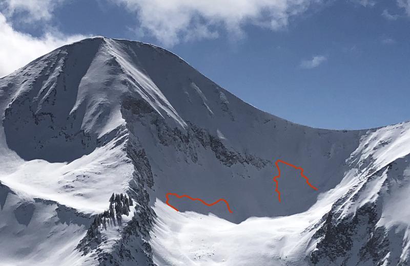
In our travels on Sunday, we observed these two natural avalanches from a distance beneath the N Face of Mount Tukuhnikivatz in Red Snow Cirque. Somewhat "pockety" in nature, they nevertheless had crowns up to 4' deep and could have easily buried or killed someone. Human-triggered avalanches such as this remain likely.
Charlie Ramser was up in Horse Creek Monday where he reported seeing this avalanche.
Ad
Avalanche Problem #1
Persistent Weak Layer
Type
Location
Likelihood
Size
Description
Heavy snowfall over the weekend along with recent deposits of wind drifted snow have piled a significant load on top of buried persistent weak layers of loose, sugary, faceted snow. On steep slopes facing NW-N-SE, deep and dangerous human triggered avalanches 2'-4' deep remain likely. Weak layers of faceted snow exist on all aspects and the recent snow load has heightened concerns on south facing slopes. Persistent weak layer problems are deceptive and avoidance of avalanche terrain is the only sure bet.
Avalanche Problem #2
Wind Drifted Snow
Type
Location
Likelihood
Size
Description
Moderate to strong NW winds overnight have easily transported yesterday's 10+" of low density snow. Today, be on the lookout for fresh deposits of wind drifted snow on the leeward sides of ridge crests and terrain features, primarily in upper elevation, wind-exposed terrain. Fresh wind drifts are recognizable by their smooth, rounded appearance and craking is a sign of instability. On northerly aspects, fresh drifts have added additional stress to buried persistent weak layers, and once triggered they will likely produce deeper and even more dangerous avalanches. Avoid steep slopes with recent deposits of wind drifted snow.
Avalanche Problem #3
New Snow
Type
Location
Likelihood
Size
Description
Human triggered avalanches within the new snow remain possible on steep slopes on all aspects today. These may occur in the form of loose snow sluffs or cohesive soft slabs. On slopes facing the north half of the compass, storm snow has increased the likelihood of triggering a deeper and more dangerous avalanche. Travel advice remains the same, avoid avalanche terrain or slopes steeper than 30 degrees.
General Announcements
This forecast is from the U.S. Forest Service, which is solely responsible for its content. This forecast describes general avalanche conditions and local variations always occur.