March Kicks Off Our Spring Campaign- Donate Now to Support Forecasting

Forecast for the Uintas Area Mountains

Mark Staples
Issued by Mark Staples on
Thursday morning, February 18, 2021
AVOID AVALANCHE TERRAIN TODAY
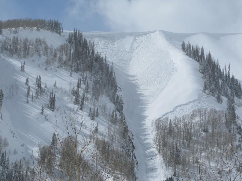
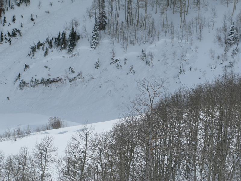
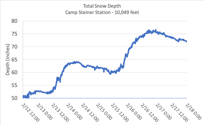
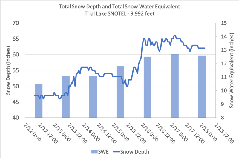
Wind and snowfall since last Friday have overloaded the fragile snowpack. DEEP, DANGEROUS, HUMAN TRIGGERED AVALANCHES ARE LIKELY and the avalanche danger is HIGH above treeline on slopes facing west, north, east and southeast.

All other slopes near and below treeline have a CONSIDERABLE avalanche danger. These areas require careful snowpack evaluations, conservative decision-making, and cautious route-finding. Nearly every snow-covered slope has some weak snow near the ground and a slab of snow on top that can be triggered and produce an avalanche.

With so much new snow, riding conditions are excellent. Take advantage of the many areas of gentle, rolling terrain that isn't steep enough to produce avalanches, but make sure to avoid being under slopes steeper than 30 degrees.
Low
Moderate
Considerable
High
Extreme
Learn how to read the forecast here
Special Avalanche Bulletin
Conditions are perfect for avalanche accidents. Heavy snowfall and drifting from strong winds have overloaded an exceptionally weak snowpack leading to extremely dangerous avalanche conditions.
All the fresh Utah powder will likely lure people into dangerous avalanche terrain, and people are likely to trigger deadly avalanches. A brief break in the weather will allow the avalanche danger to drop slightly; however, people can still trigger large and deadly avalanches if they venture onto steep slopes.
  • Avalanches triggered by people could be extremely large, very dangerous, unexpected, and deadly.
  • The Utah Avalanche Center recommends people avoid travel on or underneath slopes steeper than about 30 degrees in the backcountry for the next several days.
  • Even if you are experienced and have the proper avalanche safety equipment, you should still avoid all steep slopes in the backcountry.
Weather and Snow
Nowcast-
Yesterday an inch or two of snow fell, and north winds blew 10-25 mph with gusts up to 35 mph. This morning under mostly cloudy skies, temperatures are mostly just a few degrees above 0 F. Winds are averaging 3-9 mph and gusting up to 14 mph from the northwest.
Forecast-
Today will have some clouds and sunshine. Temperatures should reach the mid teens F. Winds at upper elevations will average 10 mph with some higher gusts from the northwest switching to the west. Lower elevations will have calm to light winds.
Futurecast-
More snow will come Friday morning along with strong westerly winds. Snowfall will ease off Friday afternoon, but more will come that night and through Saturday. Total snow amounts by the end of the day Saturday will be 5-10 inches.
Snowfall totals since last Friday are generally 20-24 inches of snow (2-2.4 inches of water).
Total snow depths range from 3.5 to 6 feet.
Scroll to the bottom of the page to see two graphs showing snowfall since last Friday.
Looking for real-time temps, snow, or wind?
Click here and then on the "western Uinta" tab for western Uinta specific, weather station network.
Recent Avalanches
Yesterday there was a very large explosive triggered avalanche in upper Weber Canyon that was 4.5 feet deep and 400 feet wide that failed on a persistent weak layer of faceted snow. Notice how it didn't just break at the ridgeline, but it broke mid-slope above a patch of aspen trees and even lower (second photo below). While this was explosive triggered, very similar avalanches can be triggered by a person today.
Other smaller slopes below this avalanche released which is a major red flag regarding the extent of the weak layers under these avalanches and the connectivity of the slabs involved.
Craig describes this avalanche in the video below.
Recent avalanche activity is found HERE.

More obs and trip reports found here.
Ad
Avalanche Problem #1
Persistent Weak Layer
Type
Location
Likelihood
Size
Description
The most prevalent and most deadly avalanche problem is both soft and hard slabs of snow failing on persistent weak layers near the ground. These weak layers of faceted, sugary snow exist at all elevations on nearly all slopes except ones facing south and southwest; however, I don't totally trust those south facing slopes just yet. Because these weak layers are stressed and ready to fracture, many slopes are waiting to avalanche as soon as someone rides on or even near them
Snow and wind since mid January have created a thick cohesive slab on top of these weak layers. At upper elevation slopes loaded by winds, this slab is very hard and 4-5 feet thick. At lower elevations this slab is softer and 2-3 feet thick.
Here's the tricky part - with such a thick and dense slab on top of these weak layers in many places, it may let several people ride a slope before producing an avalanche. The first person or the tenth person may be the one who triggers it. The main point is that tracks on a slope DO NOT mean it is stable.
Avalanche Problem #2
Wind Drifted Snow
Type
Location
Likelihood
Size
Description
Recent strong winds have formed slabs of wind drifted snow that have added stress to buried persistent weak layers. These wind slabs can be an avalanche problem by themselves but they primarily make avalanches breaking on persistent weak layers deeper, larger, and more deadly.
Winds have mostly been blowing from the north and west. However, strong winds on Tuesday came from the south and southwest before turning back to the north on Wednesday. The main point is that you can find wind slabs on many different aspects mostly above treeline.
Below is a photo of a slide of wind drifted snow that broke in weak, faceted snow near the ground
Additional Information
Total snow depth graph from the Camp Steiner weather station for Friday, Feb 12 to Thursday, Feb 18.
Total snow depth and snow water equivalent from the Trial Lake SNOTEL site for Friday, Feb 12 to Thursday, Feb 18.
W will update this forecast by 7:00 AM tomorrow, Friday, February 19th.
Your observations are important, so please let me know what you're seeing... click HERE and contribute to this amazing community based program
General Announcements
If you see or trigger an avalanche or just wanna let me know what you're seeing you can reach me directly at 801-231-2170 or [email protected]
This forecast is from the U.S.D.A. Forest Service, which is solely responsible for its content. This forecast describes general avalanche conditions and local variations always occur.