March Kicks Off Our Spring Campaign- Donate Now to Support Forecasting

Forecast for the Uintas Area Mountains

Mark Staples
Issued by Mark Staples on
Thursday morning, February 4, 2021
Dangerous avalanche conditions exist. It is likely that you will trigger avalanches several feet deep and several hundred feet wide.
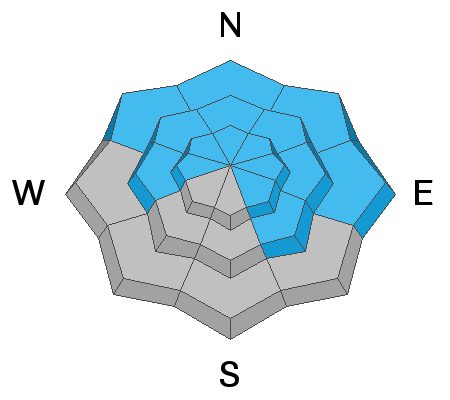
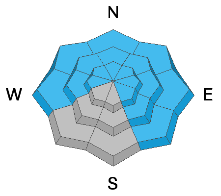
The avalanche danger is CONSIDERABLE near and above treeline on slopes facing west, north, east, and southeast.

The danger is MODERATE below treeline where avalanches may occur in places with wind drifted snow.

Here's your exit strategy- the Uinta's offer plenty of great, low angle terrain options. Simply stick with slopes less than 30 degrees in steepness where avalanches generally don't happen and make sure there's no steep terrain above or adjacent to where you're riding.
Low
Moderate
Considerable
High
Extreme
Learn how to read the forecast here
Special Announcements
It is with great sadness I report an avalanche accident which occurred last Saturday, along the Park City ridgeline, on Squaretop Peak. Our report is found here.
Our collective thoughts, prayers, and energy go out to friends and family of 57 year old, Kurt Damschroder, of Park City, Utah who was tragically killed in Saturday's accident.
Weather and Snow
Nowcast-
5-8 inches of snow (0.4-0.6 inches water) fell yesterday, and strong SW winds blew 40-50 mph in the morning. This morning upper elevation winds are blowing from the NW 20-25 mph. Temperatures are generally in the single digits F (teens at trailheads) which is 20 degrees colder than yesterday morning.
Forecast-
Today will stay cold and mostly cloudy with temperatures only reaching the mid teens F. A few snowflakes may be dancing in the air this morning but nothing will accumulate. Winds will continue from the NW at about 20 mph.
Futurecast-
Another quick storm arrives tomorrow and could bring 2-4 inches of snow. There don't appear to be any major storms coming but there may be a few inches of snow here and there.

Looking for real-time temps, snow, or wind?
Click here and then on the "western Uinta" tab for western Uinta specific, weather station network.
Recent Avalanches
Yesterday there was one intentionally triggered avalanche in upper Weber Canyon that was a 3 foot thick hard slab that broke over a wide area.
The photo below by Eric Fields shows a human triggered wind slab from Monday in Upper Moffit Basin. Breaking 2'-4' deep x 150' wide and failing on surface hoar, this slide ran on a hard, slick crust. More info here.
Click here to view recent trip reports and avalanche observations.
Ad
Avalanche Problem #1
Persistent Weak Layer
Type
Location
Likelihood
Size
Description
Persistent weak layers of faceted snow continue to plague the bottom part of the snowpack. What has changed is the slab on top. Recent snowfall, recent wind and recent warm temperatures have created a dense slab on top that will avalanche. Imagine a building with a weak foundation but we keep adding additional floors on top - eventually the whole structure will collapse.
The result of this dense slab is that avalanches are getting bigger both in depth and area. Expect avalanches that can be hundreds of feet wide and 2-3 feet deep.
  • Above and near treeline this avalanche problem is widespread.
  • Below treeline, the weak layer is widespread but the distribution of the slab on top is more pockety and a little dependent on where winds drifted snow and helped create a more cohesive slab.
What's tricky is that as the slab on top of the persistent weak layers becomes thicker and denser, avalanches get a little bit harder to trigger. This means the first person to ride on or even near a slope may not trigger it. Instead, it may be the 2nd, 3rd, or even 10th person on a slope who triggers it. Seeing tracks on slope doesn't mean it's safe.
In the video below, Craig describes an avalanche that partially buried 4 riders on Sunday. Luckily they were all ok.
Avalanche Problem #2
Wind Drifted Snow
Type
Location
Likelihood
Size
Description
Strong winds from the southwest drifted snow yesterday morning as well as southerly winds last week. Slabs of wind drifted snow may cause an avalanche by themselves, BUT the bigger issue is that they have stressed persistent weak layers of facets buried deeper in the snowpack. Winds have generally loaded slopes where these weak layers exists.
Avalanches of wind drifted snow will quickly step down and break near the ground over much larger areas.
What's tricky - winds calmed yesterday and fresh snow covered up these drifts making them harder to see.
The table below shows the strong winds that blew yesterday morning. During the day yesterday, winds calmed a bit as they shifted and blew from the west then northwest.
Additional Information
I will update this forecast by 7:00 AM tomorrow, Friday February 5th.
Your observations are import, so please let me know what you're seeing... click HERE and contribute to this amazing community based program
General Announcements
If you see or trigger an avalanche or just wanna let me know what you're seeing you can reach me directly at 801-231-2170 or [email protected]
This forecast is from the U.S.D.A. Forest Service, which is solely responsible for its content. This forecast describes general avalanche conditions and local variations always occur.