Forecast for the Uintas Area Mountains

Mark Staples
Issued by Mark Staples on
Friday morning, January 22, 2021
Today the avalanche danger is MODERATE on upper elevation slopes especially on ones loaded by strong winds early this week. Ironically, this terrain has the best coverage and the most snow, but human triggered avalanches are POSSIBLE. Any slide triggered may break into weak, sugary, faceted snow, creating a larger avalanche than you might expect.
All other slopes at mid and low elevations offer minimal snow cover and generally LOW avalanche danger.
The good news - Snowfall should begin this afternoon and continued through Saturday. The bad news - this snowfall will create very dangerous and very tricky avalanche conditions.
Low
Moderate
Considerable
High
Extreme
Learn how to read the forecast here
Avalanche Watch
THE AVALANCHE DANGER IS EXPECTED RISE TO HIGH ON SATURDAY.
FOR THE MOUNTAINS OF NORTHERN UTAH INCLUDING THE WASATCH RANGE, BEAR RIVER RANGE, AND UINTA MOUNTAINS.
HEAVY SNOWFALL TONIGHT AND TOMORROW WILL OVERLOAD A VERY WEAK SNOWPACK AND CREATE VERY DANGEROUS AVALANCHE CONDITIONS.
Special Announcements
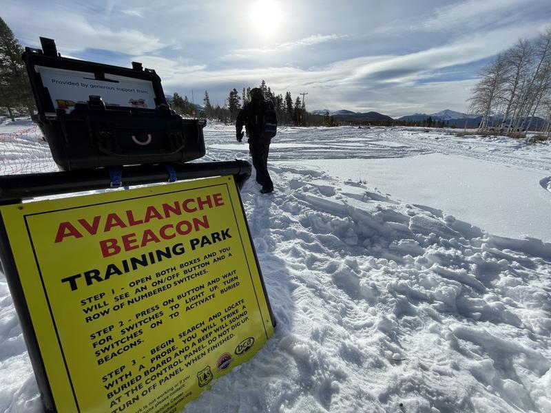
Do you have the essential avalanche rescue gear (transceiver, probe, and shovel) and know how to use them? Watch this video to see how the three pieces of equipment work together.
Ted Scroggin just installed the beacon training park at the Bear River trailhead making it really quick and easy to practice. Don't ride by it without taking 5 minutes to do a mock search.
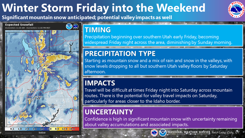
Weather and Snow
Nowcast-
This morning temperatures are hovering around 20 degrees F under cloudy skies. Ahead of the approaching storm, winds shifted to the southwest. At upper elevations, they are blowing 20 mph and gusting 40 mph.
Forecast-
Snowfall should begin this afternoon with just a few inches of new snow by the end of the day. Temperatures today should rise into the mid 20s F and winds will continue blowing from the southwest. They should blow steady 20 mph with stronger gusts over the high peaks, but remain fairly light at lower elevations.
Futurecast-
Snow will continue tonight and all day tomorrow. Scroll to the bottom of the page to see a graphic with more details about this storm. Total snow amounts could be about a foot. Sunday should have partly sunny skies followed by light snowfall Monday/Tuesday and then more possible later next week.

Looking for real-time temps, snow, or wind?
Click here and then on the "western Uinta" tab for western Uinta specific, weather station network.
Recent Avalanches
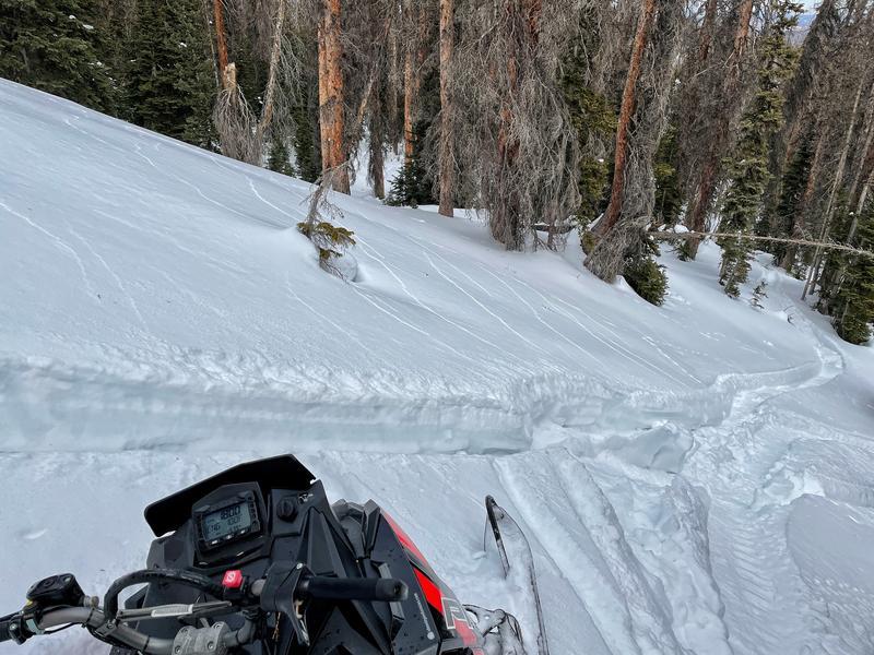
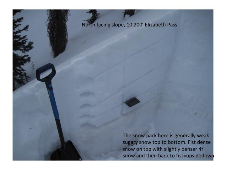
Yesterday Ted rode near Elizabeth Pass and found an avalanche that likely occurred early this week when very strong winds transported snow and overloaded the weak, shallow snowpack. Read his full observation HERE.

Check here for other trip reports and avalanche observations.
Ad
Avalanche Problem #1
Persistent Weak Layer
Type
Location
Likelihood
Size
Description
Yesterday, Craig rode in Chalk Creek, I was near Gold Hill/Moffit Peak, and Ted was at Elizabeth Pass. We all found a similar snow structure of soft snow on top, slightly denser snow in the middle, and very soft, sugary snow at the bottom. Craig describes it in the video below, and Ted's photo of the snowpack shows it as well. Overall, the snowpack is weak, faceted and shallow.
What does it mean? In some places with slightly deeper snow, mostly at upper elevations, there is a possibility of triggering an avalanche where a soft slab rests on top of this weak snowpack. Any place with a slab of wind drifted snow on top of this rotten snowpack could definitely slide as well. I experienced collapsing and cracking in many places which told me if I had gotten on a steeper slope, I could have triggered an avalanche.
Looking ahead - The approaching storm will create dangerous avalanche conditions. What's especially scary this weekend is that you won't have to ride on a steep slope to trigger an avalanche. Just going near or under a steep slope will be enough to trigger a slide that comes crashing down on top of you.
Photo of shooting cracks near Moffit Peak, an obvious sign of instability. When we see these signs before the storm, it tells us that conditions will definitely be unstable after the storm.
Video of Craig describing the snowpack structure in Chalk Creek.
Ted's photo of the general snowpack structure near Elizabeth Pass, but a similar structure exists in many places and has set the stage for avalanches and dangerous conditions when more snow comes.
Additional Information
I will update this forecast by 7:00 AM tomorrow, Saturday January 23nd.
Your observations are import, so please let me know what you're seeing... click HERE and contribute to this amazing community based program
General Announcements
If you see or trigger an avalanche or just wanna let me know what you're seeing you can reach me directly at 801-231-2170 or [email protected]
This forecast is from the U.S.D.A. Forest Service, which is solely responsible for its content. This forecast describes general avalanche conditions and local variations always occur.