Forecast for the Uintas Area Mountains

Craig Gordon
Issued by Craig Gordon on
Sunday morning, January 3, 2021
While not widespread, at and above treeline in the wind zone, you'll find pockets of CONSIDERABLE avalanche danger. Human triggered avalanches are LIKELY on steep, wind drifted slopes. Steep terrain facing the north half of the compass, and particularly slopes with an easterly component to its aspect are most suspect and should be avoided.
Mid elevations offer MODERATE avalanche danger on steep slopes facing the north half of the compass and human triggered avalanches are POSSIBLE.
In either case, once triggered, today's avalanches may break deeper and wider than you might expect.
LOW avalanche danger is found on mid and low elevation slopes, particularly those facing south, but snow cover is super thin.
Low
Moderate
Considerable
High
Extreme
Learn how to read the forecast here
Special Announcements
Andy and I installed the Are You Beeping avalanche transceiver checkpoint at the Mill Hollow trailhead. It's super easy to use.... you just slide by it and check that your gear is working properly before hitting snow.
Thanks to the generous support of our local resorts, Ski Utah, and Backcountry, discount lift tickets are now available. Support the UAC while you ski at the resorts this season. Tickets are available here.
Weather and Snow
Nowcast-
Skies are mostly clear and temperatures in the teens and low 20's. West and southwest winds bumped into the 20's right around midnight, steadily increasing into the 30's the past few hours. No new snow to report and total snow depths average just over two feet. And while conditions are slowly improving, it's still low tide in the Uinta's and travel is sorta limited to road rides and grassy slopes.
Forecast-
Look for increasing clouds with snow developing this morning. It'll be rugged along the high ridges with westerly winds blowing in the 30's, gusting to 50 mph near the high peaks. Temperatures climb into the mid and upper 20's with overnight lows dipping into the teens. Today's little storm is outta here by late in the day, delivering 2"-4" of snow in its wake.
Futurecast-
A break in the action is slated for early Monday, with a more promising storm gelling together late in the day. Snow begins late Monday night and the storm should kick into gear Tuesday. I'm cautiously optimistic... storm totals in the 5"-10" range seem reasonable.
Looking for real-time temps, snow, or wind?
Click here and then on the "western Uinta" tab for western Uinta specific, weather station network.
Recent Avalanches
Dave Kikkert stomped around upper Weber Canyon Thursday, remotely triggering the avalanche in the image above from nearly a football field away. And check out that nasty terrain trap, it's a gully, and all that snow stuffs you into it. Dave's been in the avalanche business a couple decades and he's treading lightly. A great observation and solid insight is found here.
A small, yet dangerous slide triggered late Sunday in the Wolf Creek Bowl is easily seen by the side of the road. I took a look... click HERE for more info.
You know the program... roadside attractions are still an easy grab and just 'cause you can see it from the car doesn't mean it's safe or you're good to go. And remember, our front-line health care workers are maxed out. So, let's collectively think about our decisions and the consequences that may have on others.
Ted was in Humpy Basin and found avalanches triggered early in the week. His great info, insight and advice is found HERE.
Ad
Avalanche Problem #1
Persistent Weak Layer
Type
Location
Likelihood
Size
Description
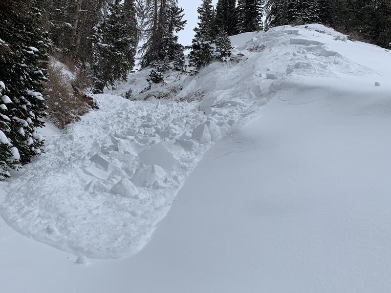
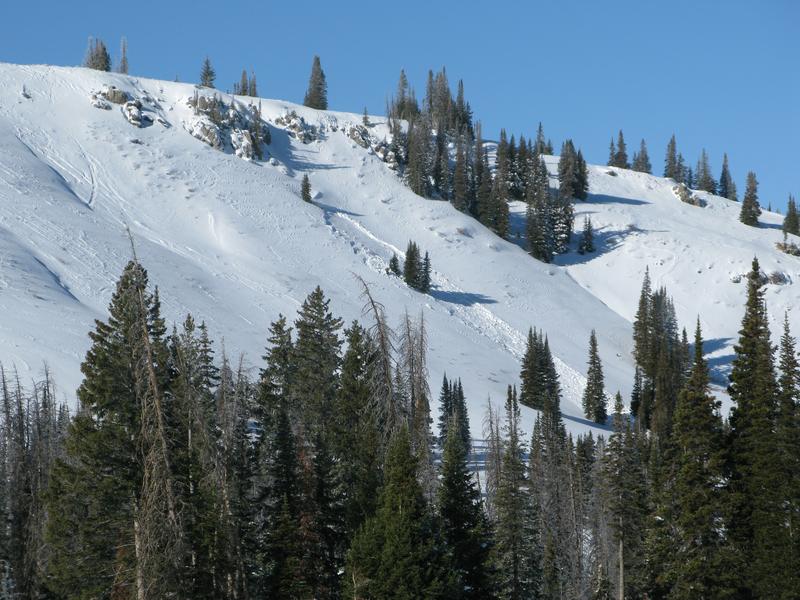
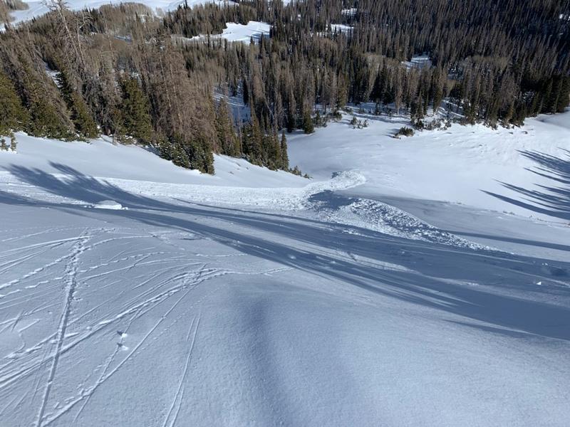
Andy Nassetta rode the south half of the range Thursday and found a recently triggered slide in the Currant Creek zone.
Nothing has changed in the past few days, as a matter of fact, it just gets spookier. Every slope my colleagues and I walk on respond with big, booming collapses, and cracks shooting everywhere, suggesting we've got a dangerous setup in our snowpack. And recent avalanches say we don't need to be on steep slopes in order to trigger avalanches.... we just need to be connected to them. And you're probably thinking, it hasn't snowed and what little snow has fallen is light, fluffy, and doesn't feel very threatening. But we're thinking like a rider wanting fresh tracks, not like a snowpack that mirrors an upside-down cake. So let's think, stronger snow on weaker snow. And, if we're thinking like the snowpack we've gotta consider not only about the snow we're riding in, but also the snow we're riding on. Fact is, this type of layering leads to tricky avalanche conditions because our snowpack needs a trigger like us to roll along and knock the legs out from underneath. And yes, we can trigger slides from a distance or from adjacent slopes, and this is the type of avalanche dragon where we can pull the entire log pile down on top of us, even if we're playing on low angle terrain. All we need is to be connected to steep terrain above us. And once triggered, today's avalanches may break wider and deeper than you might expect
But you don't have to ride blind... so, tweak small test slopes, looking for and listening to signs of unstable snow like whoomping sounds and sudden collapses of the snowpack or shooting cracks in front of your skis, board, or sled. And of course the biggest clue of all... recent avalanches, especially on the same types of slopes you wanna ride on.
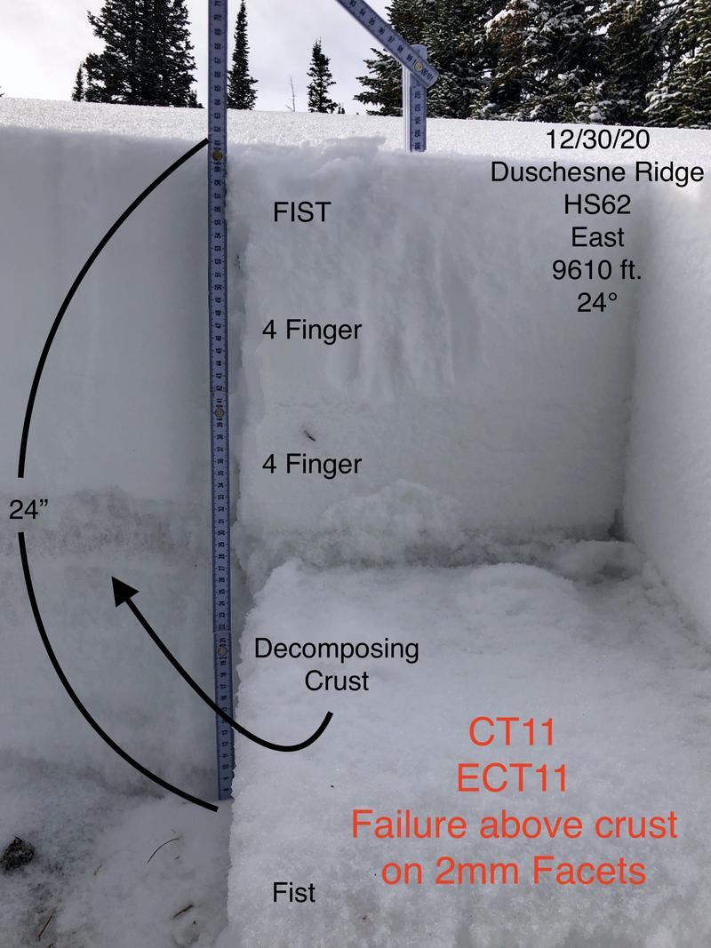
JG submitted a beautiful snow profile from his travels Wednesday which sums up the current structure of our snowpack. He's also got a great ob with some sage insight on how to travel given the sketchy conditions found here.
Avalanche Problem #2
Wind Drifted Snow
Type
Location
Likelihood
Size
Description
This week, we found that with a little coaxing, fresh wind drifts are big enough to knock you off your feet, taking you for a long and unexpected ride downslope.
There's enough light snow to blow around and overnight winds will have no problem whipping up a fresh batch of drifts that'll react to our additional weight. The vast majority of today's drifts are found on the leeward side of upper elevation ridges, but we know the Uinta's are a big place, so you'll want to be on the look out for terrain driven drifts in terrain features like chutes or gully walls. In either case, it's an easy and mostly manageable avalanche problem to avoid by simply steering clear of any fat, rounded piece of snow, particularly if it sounds hollow like a drum. And remember... our snowpack is super shallow and triggering even a small slide can take you for a body-bruising ride through rocks and stumps barely hidden under the thin snowpack.
Additional Information
Mark Staples teamed up and Ski-Doo athlete Steve Martin, and they had a great and very informative ride in the Whitney Basin. Whilst out and about, they remotely triggered a small slide on the way to investigating a large, moose triggered avalanche. In the viddy above they've got some great advice on how to ride when avalanche danger is elevated and snow depths lean.
I'll update this forecast by 7:00 AM tomorrow, Monday January 4th.
Your observations are import, so please let me know what you're seeing... click HERE and contribute to this amazing community based program
General Announcements
If you see or trigger an avalanche or just wanna let me know what you're seeing you can reach me directly at 801-231-2170 or [email protected]
The information in this forecast is from the US Forest Service which is solely responsible for its content.