The Geyser Pass Road is plowed. The surface is snow packed on dirt.
The Lower Utah Nordic Alliance (LUNA) groomed all trails yesterday.
The Utah Avalanche Center podcast's second episode of season 4 is live - Managing Risk with Avalanches, Managing Risk with a Pandemic - A Conversation with state epidemiologist Dr. Angela Dunn.
Stream
here or tune in wherever you get your favorite podcasts
There are several
new blogs that have recently been published:
Read a few
short anecdotes in a blog from UAC staff about how avalanches can surprise us.
24 Hour Snow 0" 72 Hour Snow 0" Base Depth in Gold Basin 30" Wind W 5-10 Temp 14F
Another beautiful day is on tap with sunny skies, light westerly winds, and high temps in the mid 20's. Unfortunately, a long string of beautiful days lies ahead as the Tuesday system now looks unlikely to drop down this far and nothing else is currently looming on the horizon.
Snowpack Discussion
A foot of new snow fell on Monday at the Geyser Pass Trailhead with 1" of SWE (Snow Water Equivalent). 15" fell in Gold Basin with up to 20" up high. Needless to say, this load has added significant stress to our fragile snowpack. On northerly aspects, layers of weak, sugary, faceted snow exist on top of a slick, hard melt-freeze layer. Tim Mathews was up yesterday and continued to observe collapsing and cracking. He also detailed our [poor snowpack structure.
Read his observation here. Overall coverage is still quite thin. Prior to this storm, snow depths ranged from about 6" at Geyser Pass Trailhead to 18" at Geyser Pass. Most south-facing slopes were bare. The new snow will hide a myriad of obstacles such as rocks and deadfall that lurk just beneath the surface so keep your enthusiasm in check and stick to low angle grassy slopes and meadows.
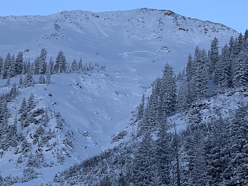
In our travels Tuesday we observed several natural avalanches in Gold Basin. Most were "pockety" in nature, averaging less than 50' wide due to an overall lack of connectivity at this time. They also tended to release further downslope, likely due to a lack of pre-existing snow higher up as well as strong winds depositing snow further down. I'll have an updated list soon.
This avalanche on the NE face of Mount Tukno was a bit of an exception as it found more snow to connect with as it ran down through the gully. Also, note the likely sympathetic release on the looker's lower left.