Observation: Moab

Observation Date
1/1/2021
Observer Name
T. Matthews
Region
Moab
Location Name or Route
Geyser Pass RD at Gold Basin JCT.
Weather
Sky
Clear
Wind Speed
Calm
Weather Comments
Happy New Year to all. What a beautiful day to take a stroll in the mountains. Calm winds in all of the terrain I traveled in today, and judging by the Pre Laurel Peak WX station the winds remained calm up there today as well. With a max gust of 8.4 mph out of the south this afternoon it's unlikely any snow was moving around. At the top of my tour in upper Pinto I did not observe any drifting snow into the Horse Creek drainage. I listed wind direction based on the terrain I traveled in and not the WX station.
Snow Characteristics
Snow Surface Conditions
Powder
Dense Loose
Faceted Loose
Snow Characteristics Comments
The 12 to 20 inches of snow that fell last Monday has stayed nice and soft in sheltered locations. Traveling today on the sunny aspects the new snow has become more dense, but has not gone through a melt freeze cycle and currently did not have a crust at the surface. Large grained SH was observed in all of the terrain I traveled in today. Makes sense with having such clear skies and calm winds this week.
Red Flags
Red Flags
Collapsing
Poor Snowpack Structure
Red Flags Comments
It took me longer today to get my first large collapse than I thought it would have. Although, most of the terrain I traveled in today had a pre existing skin track. Thanks Dave. I jumped out of the track from time to time looking for that collapse and finally got one at approx 10,700' on a S aspect behind a large pine tree in the shade. From there on out I got just about every slope to collapse that I thought I would above 10,500'. Garcia traveled in the same terrain 2 days earlier than I did, and I got to see all of the shooting cracks he got from his collapses. Most of which spiderwebbed the low angle slopes he ascended. See his observation from 20201230 here. https://utahavalanchecenter.org/observation/56826. Today I didn't get any shooting cracks out of the collapsing. The pit I dug today on a NW aspect @10,000' certainly highlights our PWL.
Avalanche Problem #1
Problem
Persistent Weak Layer
Trend
Same
Problem #1 Comments
We have multiple layers of persistent grain types buried in our current snowpack on any aspect that held old snow before our most recent storm on 12/28/20. Those aspects are most likely NW-N-E facing terrain near tree line and above in elevation. My pit today told me that at 10,000' feet on a NW aspect I was unlikely to get a slab avalanche to propagate. The slab above the weak layer(s) was a F to 4F soft slab. If I could find a harder slab in more wind exposed terrain I am sure my ECT's and PST would have produced propagation. Plus I just don't trust facets I still wouldn't ski anything steep. I'd say that the danger is decreasing in terrain below tree line and staying the same above. Especially, if the winds pick back up and move snow around.
Avalanche Problem #2
Problem
Wind Drifted Snow
Trend
Decreasing Danger
Problem #2 Comments
While the wind slab danger is likely decreasing because we have had calm to light wind speeds with only a few moderate gusts over the last 24 hours there is a good amount of low density snow to blow around in all of the skiable terrain, and when this snow blows it's going to blow into a more cohesive slab and land on a number of persistent weak layers. It's very likely that a small wind slab avalanche will step down into a deeper buried PWL. Keep in mind that our snowpack is currently very shallow and even a small ride in an avalanche is sure to grind you up.
Snow Profile
Aspect
Northwest
Elevation
10,000'
Slope Angle
10°
Comments
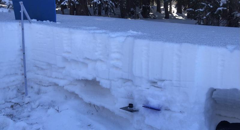
Poor snowpack structure that will likely become cranky with every new loading event.
Snowpit picture highlighting the garbage structure.
Today's Observed Danger Rating
Considerable
Tomorrows Estimated Danger Rating
Considerable
Coordinates