Join us at our 2nd Annual Blizzard Ball

Forecast for the Salt Lake Area Mountains

Nikki Champion
Issued by Nikki Champion on
Monday morning, November 30, 2020
The avalanche danger is LOW and normal caution is advised. Watch for and avoid (1) shallow wind drifts in upper elevation protected terrain, (2) fast running loose-snow avalanches in steep northerly terrain as the surface snow becomes weak and cohesionless, and (3) wet rollerballs, pinwheels, and even wet loose sluffs on the steepest sunlit slopes by midday.
REMEMBER that getting caught in even a small avalanche could have significant consequences with the risk of hitting a rock, stump, or downed timber.
Low
Moderate
Considerable
High
Extreme
Learn how to read the forecast here
Special Announcements
Announcement: Please visit this website with information about Responsible Winter Recreation by the Utah Office of Outdoor Recreation.

If you missed the 13th Annual Utah Snow and Avalanche Workshop, the recordings are available for purchase from the UAC Store.

The holiday season is right around the corner!! Looking for that special something for your partner? or yourself?
Well, we've got an easy shopping solution for you...Buy your gifts at our Pray for Snow online auction.
Weather and Snow
This morning, under clear skies there is an inversion in the mountains with trailhead temperatures in the mid-teens F and mountain temperatures in the mid-20s F. Winds are currently south southwesterly and blowing 5-10 mph at mid-elevations, with gusts near 40 mph at the upper elevations.
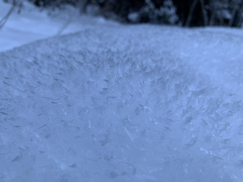
Snow depths are generally 1-2', the best riding can be found on shaded north-facing terrain that is still holding onto soft snow from Thanksgiving. In the open north-facing terrain, surface hoar continues to develop overnight. The South-facing aspects have been going through a melt-freeze cycle, leading to a firm surface crust in the morning and then becoming damp throughout the day.
Photo of the developing surface hoar from Big Cottonwood Canyon (PC: J. Johnson)

For today, we will have sunny skies in the morning with south-westerly winds and mountain temperatures in the mid-30s F until a fast-moving trough moves through the area this afternoon. This trough will bring cold temperatures and increased ridgetop winds, with gusts up to 40 mph. We could get a trace amount of snow overnight into the morning.
Recent Avalanches
Just as Drew said we might, we have begun to see some small loose-dry avalanches in the weak faceted snow.
Pro observer Mark White saw some small fast-running dry sluffs in No-name Bowl yesterday.
Video of the "facet sluffs" from No-Name Bowl (PC: M. White)
Recent observations can be found by clicking here.
Ad
Avalanche Problem #1
Normal Caution
Type
Location
Likelihood
Size
Description
While the danger is generally LOW, continue to be aware of three things:
1 - Wind Drifts: Shallow pockets of wind drifted snow from Thanksgiving’s low-density storm may still be found in upper-elevation protected terrain features. Any drifts you encounter are likely to be shallow, but with a weak snowpack underneath, any avalanches may run fast and far in steep terrain. As winds increase throughout the day pay attention to any drifting snow as new shallow wind drifts could form this afternoon.
Look for any slopes with signs of wind drifted snow, and avoiding those slopes.
2 - Dry Sluffs: The surface snow is becoming so weak and cohesionless that skiers and riders have begun to trigger "facet sluffs" in the steep northerly terrain. While relatively small in size and predictable, any size avalanche could knock you off your feet and sweep you through dangerous terrain features.
3 - Wet Sluffs: If there is any direct sun and daytime warming ahead of the front, shallow wet loose sluffs may be expected on the steepest southerly aspects by midday. Note when the snow becomes damp and unstable and then move to low angle terrain.

ANY involvement in an avalanche is likely to result in traumatic injury due to the thin, early season snow cover.
Additional Information
Looking Ahead: Although our current snowpack is thin, there is widespread variability. Strong winds in the middle of November scoured many slopes, while others got a firm wind slab compressed into the terrain. Since that time, we have had several cold and clear nights that promote a "faceting" process which weakens the snowpack, turning the snow crystals into sharp, angular, weak grains. With high pressure forecast for at least the next week, this faceting process will continue.
In the short term, the surface snow has become so weak, sluffing (loose-snow avalanches) has begun occurring on the steepest slopes.
In the long term, this weakening snow will become an issue once we get a load of storm or wind-driven snow on top of this weak snowpack structure. A perfect recipe for avalanche conditions.
Forecaster Greg Gagne gives a summary of what the snow looks like under his feet in upper Big Cottonwood on Thursday.
Weather Outlook: The longer-range models do not look particularly good for storms through mid-December.
General Announcements
This information does not apply to developed ski areas or highways where avalanche control is normally done. This forecast is from the U.S.D.A. Forest Service, which is solely responsible for its content. This forecast describes general avalanche conditions and local variations always occur.