Join us at our 2nd Annual Blizzard Ball

Forecast for the Salt Lake Area Mountains

Mark Staples
Issued by Mark Staples on
Monday morning, November 16, 2020
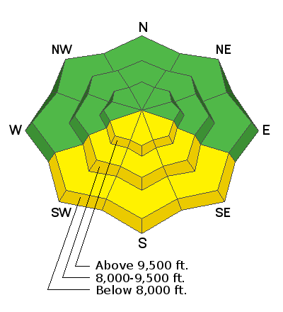
The avalanche danger is MODERATE today on south-facing slopes receiving direct sunshine where loose wet avalanches are possible. The avalanche danger is LOW on all other slopes.


What does LOW avalanche danger mean? What does a MODERATE avalanche danger mean? Read more about the avalanche danger scale HERE.
Low
Moderate
Considerable
High
Extreme
Learn how to read the forecast here
Special Announcements
Please do everything possible to avoid getting hurt for yourself and for the greater good. As you decide where and how to travel in the backcountry, consider adding just a little extra margin of safety.
Weather and Snow
This morning temperatures are 8-12 degrees warmer than yesterday morning, and temperatures at most elevations are in the low 30s F. Winds are blowing 10-15 mph from the W and SW.
Today will be very warm and sunny. Temperatures will rise into the 40s F and even the low 50s F. Winds at most ridgetops will 10-20 mph from the SW.
The snowpack was raked by very strong winds this weekend, and the gradual warm-up allowed the snowpack to settle and consolidate. There is no more blower powder, but rocks and other obstacles are now easier to see. Snow depths range from 10-23 inches.
Looking ahead, today and Tuesday will have very warm weather. Very strong winds should arrive Tuesday afternoon followed by much cooler temperatures on Thursday. There could be some snowfall later this week but only a few inches.
Recent Avalanches
No avalanches were reported yesterday.
Ad
Avalanche Problem #1
Wet Snow
Type
Location
Likelihood
Size
Description
Can you believe we are discussing wet snow? Above freezing air temperatures and sunshine will make the snow wet on southerly facing slopes that receive direct sunshine. As the snow becomes wet, it loses strength and can produce loose wet avalanches. You'll see signs that wet avalanches could begin happening when roller balls of snow begin tumbling downhill. These usually happen first near exposed rocks that heat up quickly due to sunshine and help heat up the surrounding snow.
Avoid being on southerly facing slopes as the day heats up and you see these roller balls. I don't expect loose wet avalanches to be very large or fast-moving, but they have the consistency of concrete and could hurt.
Avalanche Problem #2
Wind Drifted Snow
Type
Location
Likelihood
Size
Description
Thick, cohesive slabs of wind drifted snow formed on many slopes this weekend due to hurricane force winds and snowfall on Saturday. Most of these wind slabs should have stabilized and be well bonded to underlying snow, but there remains a chance of triggering one.
Even though the odds of triggering one of these wind slabs are small, I would consider the consequences of being swept downhill in an avalanche before committing to a slope. Some slopes have worse consequences than others. Thinking about the consequences on every slope is a great habit to develop.

Always think to yourself and ask people in your group:
(1) What type of avalanche could happen?
(2) What would happen to me if I were caught in it?
(3) Where will my partners be and could they perform a rescue?
The answers to these questions should dictate which slopes you ride and how you ride them.
Additional Information
There are a few things to remember:
  1. Hitting rocks and stumps is a real danger. Don't end your season before it starts with an injury from hitting one of these obstacles.
  2. Early season avalanches are a real possibility. It doesn't matter if you are hiking, hunting, skiing, etc., be prepared with rescue gear and a partner. Many people have died during early season snowstorms. Listen to our UAC podcast episode The Day of Madness in Little Cottonwood Canyon about a bad day in November 2011 when many avalanches were triggered, including a tragic fatality.
  3. Ski resorts all have different uphill travel policies. These closed resorts that allow uphill travel can be great places to get in a little skiing especially in you know of a rock-free slope, but it should be treated as backcountry terrain. We will soon have an up to date resource on all the ski resorts individual policies.
Until more snow begins to fall, there are plenty of resources available to begin thinking about the season today:
  1. Check out the free online avalanche course material and e-learning materials available.
  2. Start looking at weather patterns in areas you plan to ski this upcoming winter. A full list of mountain weather stations can be found HERE.
  3. Freshen up on how to read the forecast page.
  4. Look over all of your gear and make sure everything is in good, working order.
  5. Sign up for an avalanche class! Get it on the schedule early.
Bonus Material! Listen to our podcast on Early Season Essentials with Bo Torrey
General Announcements
This information does not apply to developed ski areas or highways where avalanche control is normally done. This forecast is from the U.S.D.A. Forest Service, which is solely responsible for its content. This forecast describes general avalanche conditions and local variations always occur.