


Forecast for the Uintas Area Mountains

Issued by Craig Gordon on
Saturday morning, November 14, 2020
Saturday morning, November 14, 2020
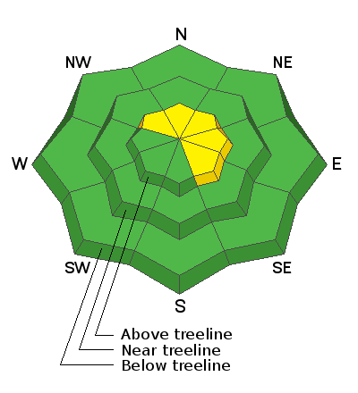
In the wind zone, at and above treeline, you'll find MODERATE avalanche danger. Human triggered avalanches are possible, especially on steep, wind drifted slopes facing the north half of the compass. Remember- even a small avalanche can easily result in a season ending, traumatic injury.
LOW avalanche danger is found on low angle, wind sheltered terrain.
Low
Moderate
Considerable
High
Extreme
Learn how to read the forecast here
 Special Announcements

Huge thanks and a big shout out to two leaders in the industry... (nope I'm not talking about Mark and I :)
More importantly- for the past 15 seasons, Tri-City Performance and Polaris have provided loaner sleds to the UAC and this year was no different. This partnership enables us to perform our field days, get into the same kind of terrain and see the same type of snow our customers are riding, and continue delivering the high caliber forecasts you've come to expect from the Avalanche Center. Bottom line... this partnership helps save lives and for that we are grateful!
 Weather and Snow
A nice blast of snow materialized for the eastern front overnight, delivering a solid 10" of snow with just over inch of water. Yes... slightly heavier than our usual snow densities. It's a bit rugged out there this morning with westerly winds blasting into 50's and 60's, gusting into the 70's along the high ridges. Currently, temperatures are in the mid teens and low 20's. And it's still pretty boney with total snow depths hovering right around two feet, so there's just enough snow to get out and about.
Look for heavy snow this morning, with total accumulations nearing two feet. Winds continue cranking into the 60's before winding down later today. Scattered snow showers linger Sunday with high pressure building next week.
Looking for real-time temps, snow, or wind?
Click here and then on the "western Uinta" tab for western Uinta specific, weather station network.
 Recent Avalanches
No new avalanche activity to report. To view trip reports and recent avalanche activity, simply click here.

Avalanche Problem #1
Wind Drifted Snow
Type
Location

Likelihood
Size
Description

The snowpack is shallow, but there's just enough snow to ride and of course, enough snow to slide. Steep terrain like this roadside attraction near Wolf Creek Pass pictured above, is the exact type of terrain where we could trigger an avalanche today. And remember- even a small avalanche this time of year will instantly end your season if you slam into a rock, or stump, or get raked through deadfall. But that doesn't mean you can't ride, you just need to tone it down a few notches. As a matter of fact, you can still have a blast on lower angle terrain.
Additional Information
I'll update this information as conditions warrant and the snowpack develops. Once we get rolling and winter gets going in earnest, you can expect detailed daily avalanche advisories updated by 7:00 AM.
Your observations are import, so please let me know what you're seeing... click HERE and contribute to this amazing community based program
Information on outdoor recreation - The State of Utah created this webpage with information about recreating on both state and federal public lands during the current health crisis.
Skiing and riding at closed ski resorts - Some resorts allow access now, and some do not. Please check HERE for the latest info on ski area access.
New to the backcountry (including riding at closed resorts) - Watch the award-winning, 15 minute Know Before You Go video, or take the 5-part, free online-learning series.
General Announcements
If you see or trigger an avalanche or just wanna let me know what you're seeing you can reach me directly at 801-231-2170 or [email protected]
The information in this forecast is from the US Forest Service which is solely responsible for its content.