March Kicks Off Our Spring Campaign- Donate Now to Support Forecasting

Forecast for the Uintas Area Mountains

Craig Gordon
Issued by Craig Gordon on
Wednesday morning, April 1, 2020
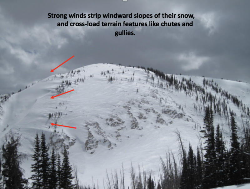
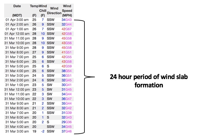
Heads up... avy danger continued ramping up overnight and any slide triggered may break deeper and wider than you might expect-
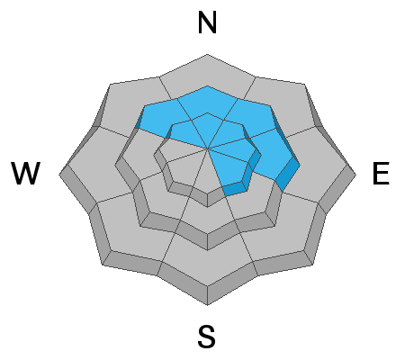
In upper elevation terrain, especially in the wind zone at and above treeline, CONSIDERABLE avalanche danger exists on wind drifted slopes. Human triggered avalanches are LIKELY on steep, leeward slopes facing the north half of the compass, particularly those with an easterly component to its aspect.
And while not as widespread, even mid elevation terrain is getting in on the act. You'll find pockets of MODERATE avalanche danger on wind loaded slopes and human triggered slides are POSSIBLE in steep terrain with recent deposits of wind drifted snow.
Your risk reducing exit strategy is this- good riding with more predictable avalanche danger is found with some loss of elevation. Wind sheltered mid and low elevation terrain offers generally LOW avalanche danger.
Low
Moderate
Considerable
High
Extreme
Learn how to read the forecast here
Special Announcements
Spring Awareness Campaign - Help us save lives through avalanche forecasts and education. Consider making a donation before April 8th.

Information on outdoor recreation - The State of Utah created this webpage with information about recreating on both state and federal public lands during the current health crisis.

January 5, 2019 - Read this collection of 6 stories and a podcast about that day with a low avalanche danger, 8 skier triggered avalanches, four catch and carries...a partial and critical burial, and a trip to the emergency room.
Weather and Snow
Currently-
Under mostly cloudy skies, a weak and mostly moisture starved cold front, slides north of our area. A few snow showers hover over the region and current temperatures register in the mid 20's and low 30's. Southwest winds continued cranking overnight with hourly averages in the 30's and 40's, gusting into the 60's along the high peaks. Warm temperatures and strong winds wrecked a lot of cold, settled snow and change the landscape as I type. So... if you're looking for soft settled snow, wind sheltered, mid elevation terrain is the ticket.
More Uinta weather network info is found here. Simply click on the Western Uinta tab.
For today-
A slow moving cold front chugs towards our region producing mostly cloudy skies, light snow showers and high temperatures climbing into the mid and upper 30's. Southwest winds are gonna be a nuisance, blowing in the 30's and 40's with gusts in the 60's along the high peaks.
Futurecast-
A decent shot of snow finally crosses the area late tonight into early Thursday, delivering 3"-6" of snow, before winding down right around sunrise tomorrow.
Recent Avalanches
By days end yesterday, steep, wind drifted terrain in the wind zone became touchy. Big enough to catch your attention, the natural slide in the image above in upper Moffit Basin was initiated with a cornice fall and then quickly fanned out as it crashed onto the slope below.
To view additional trip reports and recent avalanche activity, simply click here.
Ad
Avalanche Problem #1
Wind Drifted Snow
Type
Location
Likelihood
Size
Description
Ted was on the east side of the range and found avalanche danger changing late in the day. More on his travels and insight found here.
Winds began blowing yesterday, continued through the night, and there's no shortage of loose snow available to blow around and form drifts that'll react to our additional weight. This combo not only changed the landscape, it also ramped up the avy danger. The good news is... this avalanche problem is pretty straight-forward and mostly confined to upper elevation, leeward terrain facing the north half of the compass. However, due to the prolonged strength and duration of wind speed, I suspect drifts formed lower down slope then we might expect and also formed around terrain features like chutes and gullies. So here's what changed on the front line... yesterday's mostly manageable soft drifts are now today's bigger brother version- they're stiff, they'll break deeper and wider than you might expect.... they'll pack a punch.
So, it's time to recalibrate and the key to riding safely today is... be flexible with your travels plans and adjust objectives if you're starting to see or feel obvious clues to unstable snow like shooting cracks, sudden collapses, or the biggest clue to avalanches and of course, that's avalanches, especially if they're occurring on the same type of slope you wanna ride on!
Above is a 24 hour data dump for Windy Peak (10,662') illustrating the punishing winds along the high peaks.
Additional Information

Skiing and riding at closed ski resorts - Some resorts allow access now, and some do not. Please check HERE for the latest info on ski area access.

New to the backcountry (including riding at closed resorts) - Watch the award-winning, 15 minute Know Before You Go video, or take the 5-part, free online-learning series.
General Announcements
The information in this forecast expires in 24 hours, but will be updated by 7:00 AM Thursday Apr. 2nd.
This forecast is updated daily by 7:00 AM.
In the mean-time, if you see or trigger an avalanche or just wanna let me know what you're seeing you can reach me directly at 801-231-2170
The information in this forecast is from the US Forest Service which is solely responsible for its content.