Forecast for the Moab Area Mountains

Eric Trenbeath
Issued by Eric Trenbeath on
Thursday morning, March 26, 2020
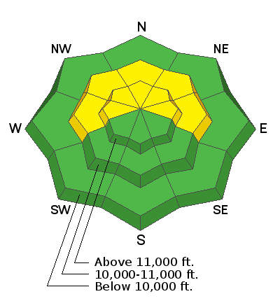
Strong southerly winds have continued to blow and drift snow and the avalanche danger is MODERATE on steep slopes facing W-N-E. Triggered wind drifts have the potential to step down into weak, sugary, faceted snow, and human triggered avalanches 2' - 4' deep are possible. Avoid steep, wind drifted slopes and likely trigger points such as steep convexities or shallow snowpack areas near rock outcroppings. Stay conservative in your decision making, the threat for dangerous avalanches remains real.
Low
Moderate
Considerable
High
Extreme
Learn how to read the forecast here
Special Announcements
Road Conditions: Grand County plowed the road and parking lot on Monday. The surface is down to the dirt and will be muddy later in the day.
Grooming: LUNA packed out trails on Sunday but things were still a bit rough. A couple inches of snow have fallen since then.
UAC operating schedule - We will continue issuing regular avalanche forecasts into mid April.
Spring Awareness Campaign - The UAC counts on donations from the backcountry community. We know these are uncertain times and any donation during our awareness campaign will help us continue providing avalanche forecasting and education.
CDC Guidelines - Even in the backcountry and in parking lots, please follow CDC guidelines like limiting group size and keeping a distance of at least 6 feet from other people to protect yourself and others. Read the guidelines HERE.
Taking risks - Be extra conservative to avoid the risk of accidents which can stress the capacity of our medical system.
New to the backcountry (including riding at closed resorts) - Watch the award-winning, 15 minute Know Before You Go video, or take the 5-part, free online-learning series.
Weather and Snow
24 Hour Snow 0" Weekly Snow 22" Base Depth in Gold Basin 68" Wind SSE 30-35 G50 Temp 27F
Wind, temperature, humidity on Pre Laurel Peak (11,700')
Storm totals at Gold Basin Study Plot (10,000').
Snotel site near Geyser Pass Trailhead (9600').
NWS weather forecast
Weather: Strong southerly winds will continue to hammer the mountains today. Skies will be mostly sunny and high temps will be in the mid 30's. Clouds and scattered showers will develop tonight as a low-pressure trough and associated cold front move into the region. Lacking in moisture it looks like we'll only see a couple of inches from this system but we should see a decrease in winds as the storm moves through. Look for snow showers tomorrow, moderate SW winds, and high temps in the mid 20's. Saturday looks to be dry and mostly sunny.
Snowpack: Not much has changed. Recent and wind drifted snow has piled up on a fragile snowpack that in many areas is comprised largely of weak, sugary, faceted snow. Weak snow can be found on all aspects but the weakest snow exists on northerly facing slopes right around treeline and below. Alpine areas generally have a deeper and stronger snowpack, especially out in the middle of concave bowls. However, slope margins, wind-swept areas, and areas right around rocks, cliffs, or sub-ridges have a much thinner snowpack. Weak, faceted snow exists in these areas. The recent spate of natural and human triggered avalanches in the alpine have included areas of wind drifted snow that have propagated into areas with weak, faceted snow.
Recent Avalanches
On Sunday, I and others observed this large natural avalanche in Red Snow Cirque. It likely ran Saturday afternoon or evening after an increase in southerly winds. Like other slides of late, it involved wind drifted snow over top of weak, faceted snow.
I also updated the report sent in by Casey Bateman with a photo of the natural avalanche that occurred in Exxon's Folley on Thursday.
Ad
Avalanche Problem #1
Persistent Weak Layer
Type
Location
Likelihood
Size
Description
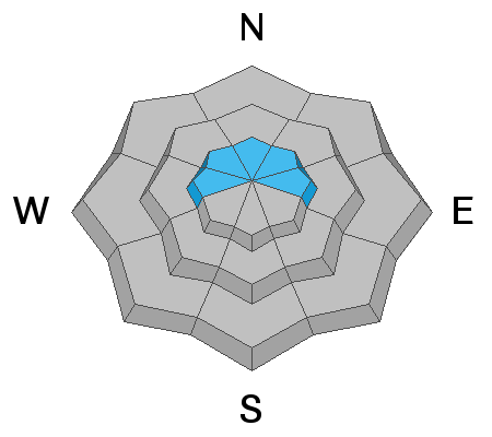
Recent and wind drifted snow have built slabs 2'-4' thick on top of a persistent weak layer of sugary, faceted snow that formed in February. You are most likely to trigger an avalanche involving this persistent weak layer on steep, wind loaded, north through easterly facing slopes right around treeline, or in shallower, rocky areas in the alpine. Avoid likely trigger points such as steep convexities or thinner snowpack areas around rock outcroppings.

Avalanche Problem #2
Wind Drifted Snow
Type
Location
Likelihood
Size
Description
Southerly winds continue to blow and drift snow on to north through easterly facing aspects. New wind drifts overly old and many slopes are fat and loaded. Drifted slopes are recognizable by their smooth, rounded, or rippled appearance and cracking is a sign of instability. In these same areas, a triggered wind slab could step down into a buried persistent weak layer causing a deeper and more dangerous avalanche. Continue to avoid steep, wind loaded slopes.
General Announcements
Check out the avalanche beacon training park at the Geyser Pass Trailhead and practice your rescue skills!
This forecast is from the U.S. Forest Service, which is solely responsible for its content. This forecast describes general avalanche conditions and local variations always occur.