UDOT PLANNED AVALANCHE CLOSURES!!

Forecast for the Salt Lake Area Mountains

Trent Meisenheimer
Issued by Trent Meisenheimer on
Saturday morning, January 11, 2020
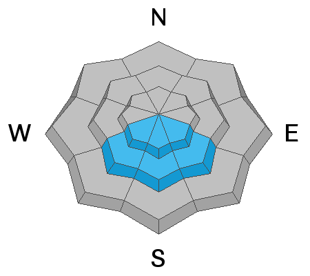
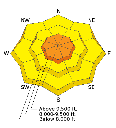
Today, will be a day of RISING avalanche danger. We have a CONSIDERABLE avalanche danger on all steep upper elevation slopes where westerly winds have deposited fresh drifts of wind blown snow. There is a MODERATE danger on all mid and lower elevations slopes. The avalanche danger could spike rapidly today depending on how fast the snow falls. Natural avalanches are possible and human triggered avalanches are likely.

There are three avalanche problems to watch for: (1) soft slabs of wind drifted snow, (2) deeper slabs about 3 feet deep breaking near an ice crust on southerly facing slopes, and (3) sluffing and soft slabs within the new snow.

Here's the thing - the danger can vary widely. Any wind loaded slope will be more likely to produce an avalanche than a non-wind loaded slope. Southerly facing slopes with an ice crust/weak layer combo about three feet deep will be more dangerous than slopes without this layer.
Low
Moderate
Considerable
High
Extreme
Learn how to read the forecast here
Special Announcements
Get discount lift tickets HERE. Thanks for this generous support from Utah Ski Resorts and Ski Utah. All proceeds go directly to supporting the UAC.
New to the backcountry or in need of a refresher? Consider taking a companion rescue course offered at Woodward Park City, January 14, 5:30-9 p.m.
Be sure to catch up on what happened this past week. Greg Gagne put together a great recap found HERE
Weather and Snow
Under increasingly cloudy skies the mountain temperatures are hovering in the mid to upper teens °F. Westerly winds picked up in the last few hours and are currently blowing 15-20 mph gusting into the mid 30's at the upper elevations. Mid elevation (9,000') winds are blowing 10-15 mph with gusts into the low 30's.
For today, we can expect snowfall to begin around 8:00 am this morning with heavy snow at times. We could see periods of heavy snowfall with 1-2" inches of new snow per hour this morning. The forecast is 6-12" of new snow throughout the day today with a storm total of 12-18" of new snow by Sunday morning. The westerly winds are forecasted to remain steady out of the west for most of the morning before calming down this afternoon. Later this evening and overnight we will see another round of snow and the winds will increase once again.
The National Weather Service released a mountain weather briefing yesterday afternoon and it can be found below in additional information.
Recent Avalanches
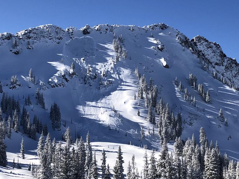
Yesterday was a quite day in the backcountry with only one recent avalanche reported. This avalanche was off Cardiac Ridgeline and it appears to be a wind drifted avalanche. It was about 50' feet and it ran down to the flat bench covering some ski tracks as well as a skin track. Ski areas produced a few avalanches with explosives that were big enough to bury a person. The most impressive avalanche was from the East Castle in un-skied terrain where the avalanche failed into faceted snow at the ground. This slope was at 10,800' in elevation and was 3-4' deep running into the flats. It was also a repeater slide that perviously avalanched in the same location on December 14th 2019. (Picture below: Alta Ski Patrol)
A full list of recent avalanches and observations can be found HERE.
Photo: Slab avalanche from explosive work in un-skied terrain.
Ad
Avalanche Problem #1
Wind Drifted Snow
Type
Location
Likelihood
Size
Description
Westerly winds picked up last night around 8:00 pm. Currently they are blowing steady 15-20 mph gusting into the upper 30's across the ridgelines. With so much snow available for transport it will be no surprise to see Wind Drifted Snow avalanches today. Look for and avoid any new drift of wind blown snow. Wind Drifted Snow often looks rounded, wavy, and pillowy. It won't take a lot of wind to whip the five star powder into soft slabs of wind drifted snow. These soft slabs could become large enough to catch, carry, bury or kill a person. Cracking is an obvious clue to unstable snow.
Cautious route-finding and conservative decision-making will be essential today.
Avalanche Problem #2
New Snow
Type
Location
Likelihood
Size
Description
The wild card will not be how much new snow falls today. It will be the RATE at which the new snow falls. We call this precipitation intensity - as of now we are forecasted to hit rates of 1-2" of new snow per hour this morning. If this happens the avalanche danger could spike rapidly and possibly reach considerable on all aspects. Keep an eye to the sky, if the snow rate rapidly increases and you start seeing loose snow avalanches trickling down you know the danger is on the rise and it's time to alter your plans accordingly.
Small test slopes and shovel tilt tests will give you a clue into the new snow instabilities. It's deep out there and places like terrain traps, and gullies will only increase the odds of being buried deep.
Avalanche Problem #3
Persistent Weak Layer
Type
Location
Likelihood
Size
Description
South aspects: On aspects that face southeast, south and southwest at the mid and upper elevations you can find a poor snowpack structure. Here you will find an ice crust with weak snow above and below the crust. Many human triggered slides happened as a result of this set up. It's been about a week since we've seen activity on this layer. However, with more snow (weight) and wind forecasted today we have to assume this layer could become active once again. This problem should be avoided for today and until we get more information it should not be trusted.
Northerly aspects: Yesterday, I dug four snowpits in Mineral Fork on elevations from 7,800' to 9,300' and consistently found a weak layer of snow buried roughly 2-3' deep in the snowpack. I found this layer on slopes that faced northeast, north and east. In my snowpit tests I was able to propagate a crack across the column and to me this says I could trigger an avalanche as a result. I am not the only one finding this layer. Drew Hardesty found it in the Meadow Chutes. Mark Staples found it in Bountiful. Currently, it's producing results (propagation) in our snowpit tests but we are yet to see any avalanche activity on this layer. It's worth noting and remembering this layer for now.
What to do today? First, I would avoid steep southerly facing slopes where this layer most likely exists. Second, avoid all steep wind drifted terrain. Before committing to a steep north, east, or west facing slope, I would dig 3 feet deep and perform an Extended Column Test (ECT) on a small slope or a low angle slope with a similar aspect and elevation to the slope you hope to ride. If the ECT fractures across the entire column, that is bad and I would not ride the slope. Let us know what you find.
Wondering how to perform an extended column test? Click HERE to watch a video.
Additional Information
General Announcements
This information does not apply to developed ski areas or highways where avalanche control is normally done. This forecast is from the U.S.D.A. Forest Service, which is solely responsible for its content. This forecast describes general avalanche conditions and local variations always occur.