Fall Auction is now live! Check it out now

Forecast for the Ogden Area Mountains

Greg Gagne
Issued by Greg Gagne on
Friday morning, November 29, 2019
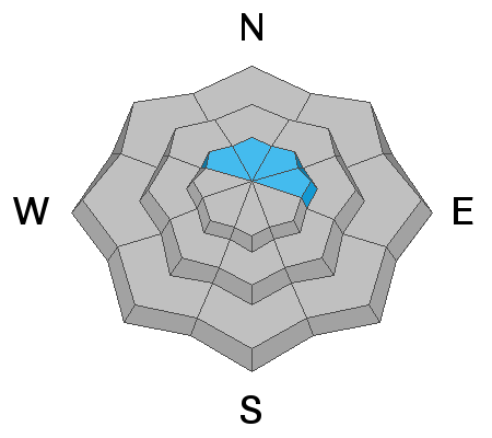
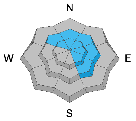
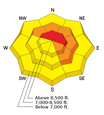
The avalanche hazard is HIGH on upper elevations facing northwest through east where avalanches may fail on a weak layer of snow down at the ground. At the mid-elevations, the hazard is CONSIDERABLE on aspects facing northwest, through northeast and southeast. At low elevations the hazard is Moderate.
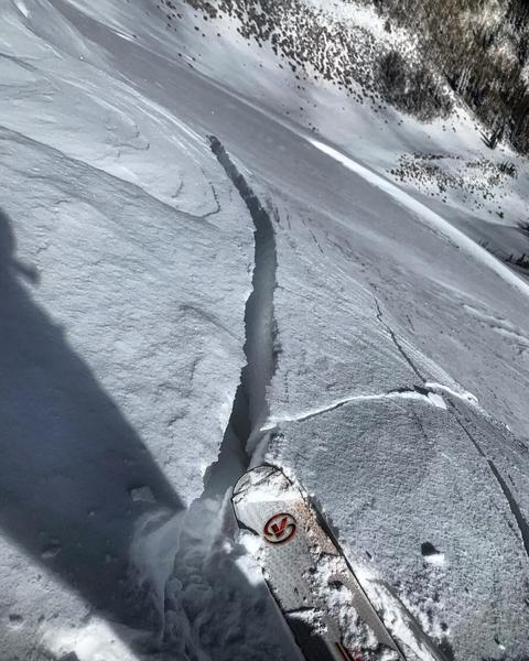
South winds have likely created fresh wind drifts at the mid and upper elevations, with heavy, dense snow at all elevations. Travel in avalanche terrain is not recommended - avoid being on and underneath any slopes steeper than 30 degrees.
Low
Moderate
Considerable
High
Extreme
Learn how to read the forecast here
Special Announcements
The First Annual Statewide Avalanche Awareness Week is December 2-7. We have a week full of fun and educational events planned. Check out the schedule here.
Weather and Snow
Temperatures this morning in the Ogden mountains are in the 20's F and winds are from the south, averaging less than 10 mph, with gusts in the teens and 20's along upper ridgelines. However, southerly winds were moderate to strong overnight, with gusts in the 30's and 40's mph, with gusts atop Mount Ogden in the 50's mph. Overnight, 1-3" of new snow has fallen.
There are some impressive snow amounts reported from the Ogden mountains since Thanksgiving morning. In the past 36 hours this includes
Near Snowbasin - 22" containing 1.4" water
Near Powder Mountain - 20" containing 2.2" water
The Ogden mountains have quickly (and I mean quickly) adorned a generous snowpack with depths of 2-4'
Today's weather includes temperatures in the 20's with continued snowfall. Winds will gust into the 20's from the south/southwest. Expected snowfall today is 2-4". A strong cold front will enter the region this afternoon, with winds shifting to the west and temperatures dropping. Expect heavy snowfall behind this front later this afternoon and overnight.
Recent Avalanches
Reports from the Ogden backcountry included localized cracking in the storm snow. Ogden-area resorts reported sensitive storm snow during the morning hours, including some natural activity in steep rocky terrain. Overall conditions seemed to stabilize during the afternoon.
Ad
Avalanche Problem #1
Persistent Weak Layer
Type
Location
Likelihood
Size
Description
The good news is that the Ogden mountains had very little snow prior to the onset of this Thanksgiving week storm. However, there was some old snow on northerly aspects at the highest elevations, and this snow became weak, sugary, and faceted. Heavy snowfall over the past two days combined with strong winds from the south has overloaded this weak snow, creating areas where avalanches failing down at the ground are possible.
We have limited data about his old, faceted snow and must assume any slope that had snow prior to this week has this weak faceted snow. Down in the Salt Lake mountains, several avalanches failing at this layer of weak snow were triggered remotely (from a distance) on Thursday, indicating how this persistent weak layer avalanche problem can only be managed by avoiding avalanche terrain on northerly aspects where old snow may be present.
Doug Wewer snapped a few great photos of old snow coverage on Ben Lomond Peak like the one below.
Avalanche Problem #2
Wind Drifted Snow
Type
Location
Likelihood
Size
Description
Moderate to strong winds overnight from the south have likely created fresh wind drifts at the mid and upper elevations. Watching for signs of instability including cracking in these fresh wind slabs, as illustrated in the following photo: (Mark White)
Avalanche Problem #3
New Snow
Type
Location
Likelihood
Size
Description
Instabilities within the storm snow have largely settled out, but continued snowfall today may produce avalanching in the storm snow. This includes sluffing on steep slopes as well as denser storm slabs. There are several density changes within the storm snow, and this may complicate assessing the stability of the new snow.
General Announcements
This information does not apply to developed ski areas or highways where avalanche control is normally done. This forecast is from the U.S.D.A. Forest Service, which is solely responsible for its content. This forecast describes general avalanche conditions and local variations always occur.