Fall Auction is now live! Check it out now

Forecast for the Ogden Area Mountains

Mark Staples
Issued by Mark Staples on
Thursday morning, November 28, 2019
Today's rapid, heavy snowfall has created several avalanche problems. At the highest elevations on northerly facing slopes old faceted snow exists under the new snow and will make a weak layer on which avalanches can fracture. Southerly winds, as well as warming temperatures, have likely created soft slabs in the new snow that can also make an avalanche.

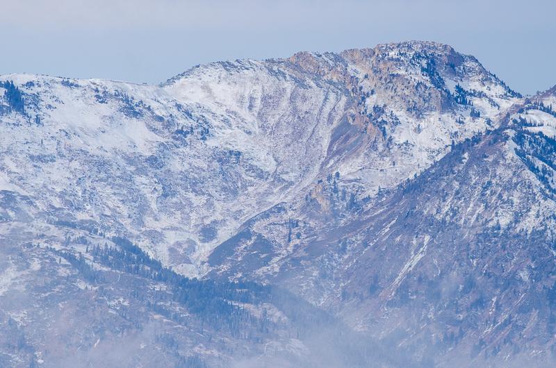
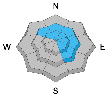
The avalanche danger is HIGH at the highest elevations on northerly and east-facing slopes that likely have a layer of old snow where the travel advice is to avoid all avalanche terrain. Winds blowing from the southwest have created a CONSIDERABLE avalanche danger at mid-elevation northerly and east-facing slopes as well as upper elevation southeast facing slopes. All low elevation terrain has a MODERATE avalanche danger.

The best thing to do is simply avoid avalanche terrain today which is any slope steeper than 30 degrees. Exercise patience and give the new snow time to settle and gain strength.
Low
Moderate
Considerable
High
Extreme
Learn how to read the forecast here
Special Announcements
The First Annual Statewide Avalanche Awareness Week is December 2-7. We have a week full of fun and educational events planned. Check out the schedule here.
Weather and Snow
Since yesterday morning the Ogden mountains have been pummeled by snow and it is snowing hard this morning. As of 5 a.m. snow totals are:
  • Near Snowbasin - about 20 inches of snow (1.15 inches of water).
  • In the Ogden valley - about 30 inches of snow since yesterday.
  • At the Ben Lomond Peak SNOTEL - approximately 3 feet of snow (2.7 inches of water).
  • Near Powder Mountain - about 22 inches of snow (1.5 inches of water)
Temperatures are hovering in the mid 20's this morning above 7000 feet and are about 10 degrees warmer than yesterday morning.
Winds are blowing from the southwest. On Ogden Peak, these winds were averaging 20 mph and gusting to 30 mph but had decreased at 6 a.m. to 9 mph with gusts of 17 mph.
Today's weather should be a continuation of what's happening this morning with a steady stream of moisture from the south over the Wasatch Mountains. Strong winds should blow from the southwest and temperatures should rise into the upper 20s F. Another foot of snow seems likely.
Recent Avalanches
None reported
Ad
Avalanche Problem #1
Persistent Weak Layer
Type
Location
Likelihood
Size
Description
The Ogden mountains were mostly bare ground prior to Monday; however, there was some old snow at the highest elevations. This old snow became weak and faceted. Today's snow should be overloading the old snow at the ground. Not only do the Ogden mountains have a lot of new snow, this new snow has been falling at a rapid rate. This rapid loading combined with wind loading from southerly winds, should make avalanches likely at the highest elevations.
We have limited data about his old, faceted snow and must assume any slope that had snow last weekend likely has this weak faceted snow.
Doug Wewer snapped a few great photos of old snow coverage on Ben Lomond Peak like the one below.
Avalanche Problem #2
Wind Drifted Snow
Type
Location
Likelihood
Size
Description
It seems that winds have not been as strong in the Ogden area as they have been in other parts of the Wasatch Range. Regardless, it's fair to assume that southerly winds have been transporting snow at ridgelines. These fresh slabs of wind drifted snow should easily avalanche today.
Avalanche Problem #3
New Snow
Type
Location
Likelihood
Size
Description
Soft slab avalanches in the new snow are a definite possibility today for several reasons. One is simply the amount of new snow and how quickly it has been falling. Second is that temperatures have warmed and the new snow may be upside down which means there is warmer denser snow on top of colder lighter snow.
General Announcements
This information does not apply to developed ski areas or highways where avalanche control is normally done. This forecast is from the U.S.D.A. Forest Service, which is solely responsible for its content. This forecast describes general avalanche conditions and local variations always occur.