AVALANCHE WARNING!! Tap for info

Forecast for the Moab Area Mountains

Eric Trenbeath
Issued by Eric Trenbeath on
Tuesday morning, January 22, 2019
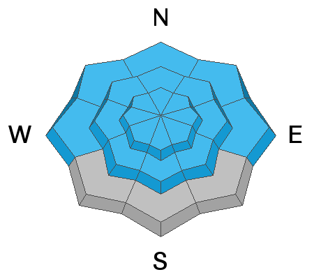
AVALANCHE WARNING. Heavy snowfall and strong winds have created dangerous avalanche conditions and the danger is HIGH today on all aspects at mid and upper elevations. Natural and human triggered avalanches are likely. At low elevations the danger is CONSIDERABLE. Travel in avalanche terrain is not recommended. Backcountry travelers need to have excellent route finding skills and stay off of, and out from under steep, avalanche prone terrain.
Low
Moderate
Considerable
High
Extreme
Learn how to read the forecast here
Avalanche Warning
THE FOREST SERVICE UTAH AVALANCHE CENTER IN MOAB HAS ISSUED A BACKCOUNTRY AVALANCHE WARNING.
* TIMING... 6 AM MST TUESDAY THROUGH 6 AM MST WEDNESDAY.
* AFFECTED AREA...FOR THE LA SAL MOUNTAINS OF SOUTHEASTERN UTAH
* AVALANCHE DANGER...THE AVALANCHE DANGER HAS RISEN TO HIGH.
* REASON/IMPACTS...RECENT HEAVY SNOW COMBINED WITH WIND HAS CREATED WIDESPREAD AREAS OF UNSTABLE SNOW AND DANGEROUS AVALANCHE CONDITIONS. BOTH HUMAN TRIGGERED AND NATURAL AVALANCHES ARE LIKELY. STAY OFF OF AND OUT FROM UNDER SLOPES STEEPER THAN 30 DEGREES. AVOID TRAVEL IN AVALANCHE TERRAIN.
Special Avalanche Bulletin
Special Announcements
Grand County will be plowing today. Expect to find the gate locked while plowing is in progress. If you go up today, hold off until the afternoon.
We are sorry to report that a skier was buried and killed in a large avalanche around 5 pm Friday by Electric Lake, on the Manti/Skyline Plateau. Our sincere condolences go out to the victim's family and friends. Here is the accident report.
We will be offering a Backcountry 101 avalanche course on Feb 8, 9. It's a great way to up your avalanche knowledge with both classroom, and hands on field instruction. Click here for more details and to register. Much thanks to Moab Gear Trader for sponsoring this course! Please visit them for all of your winter backcountry needs.
Weather and Snow
Wow, that was a seriously over performing storm! 16" of snow has fallen at the Gold Basin study plot since about 3:00 p.m. yesterday afternoon. Strong southerly winds blew most of the day yesterday gusting as high as 60 mph. They swung around to the WNW around 7:00 p.m. where they have been averaging around 20 mph with gusts in the 40's. Look for clearing skies and continued strong NW winds. High temps will be in the mid teens but wind chill values will be well below zero. Brrrrr.
It's exciting to see all this snow, but if we had ski areas here, I would recommend going to them today. With strong NW winds, frigid temperatures, tough trail breaking, and very dangerous avalanche conditions, I can think of better things to do today.
Base depth in Gold Basin: 64"
New snow totals in Gold Basin (10,000')
Snow totals at the Geyser Pass Trailhead (9600')
Wind, temperature, and humidity on Pre Laurel Peak (11,700')
National Weather Service point forecast.
Recent Avalanches
It's been an active week for avalanche natural avalanche activity and numerous slides have been reported throughout the range. I'm working on a compiling a list, but a trip into Gold Basin revealed a widespread cycle with avalanches breaking 3' deep on W-N-E aspects. Talking Mountain Cirque was particularly affected. A wind drifted slope broke out up to 7' deep, and the floor of the entire basin was covered in debris. And an infrequently running slide path ran full track, depositing debris into a stand of mature trees.
Ad
Avalanche Problem #1
New Snow
Type
Location
Likelihood
Size
Description
Avalanches within the new snow will be likely on steep slopes on all aspects today, and with 16" or more of new snow, these avalanches will be deep enough to bury you. These slides will occur both as loose snow sluffs, and cohesive soft slabs. Blowing and drifting within the new snow will also create deep and dangerous wind slabs. With the help of the wind, natural releases from above will also be likely as accumulating drifting snow reaches it's breaking point. Stay off of, and out from under steep slopes today, and give run out zones a wide berth.
Avalanche Problem #2
Persistent Weak Layer
Type
Location
Likelihood
Size
Description
New and drifting snow continues to dangerously overload buried persistent weak layers in the snowpack. Last week saw a fairly widespread cycle with avalanches failing 2'-4' deep on average, with at least one slope breaking up to 7' deep. Slopes that haven't run are primed and ready, and we could see repeaters on slopes that already have. Though it has primarily been a problem on northerly facing slopes, weak, sugary layer are present on all side of the compass, and we are now getting enough of a load to stress them. Bottom line, deep and dangerous, human triggered avalanches are likely on steep slopes at mid and upper elevations.
Avalanche Problem #3
Wind Drifted Snow
Type
Location
Likelihood
Size
Description
This has all been covered above, but blowing and drifting snow on all aspects has created dangerous avalanche conditions. Avoid avalanche terrain.
General Announcements
Your information can save lives. If you see anything we should know about, please help us out by submitting snow and avalanche observations HERE. You can also call me at 801-647-8896, or send me an email: [email protected].
Support the UAC through your daily shopping. When you shop at Smith's, or online at REI, Backcountry.com, Patagonia, NRS, Amazon, eBay by clicking on these links, they donate a portion of your purchase to the UAC. If you sell on eBay, you can have your See our Affiliate Page for more details on how you can support the UAC when you shop
This advisory is from the U.S.D.A. Forest Service, which is solely responsible for its content. This advisory describes general avalanche conditions and local variations always occur.