AVALANCHE WARNING!! Tap for info

Forecast for the Moab Area Mountains

Eric Trenbeath
Issued by Eric Trenbeath on
Monday morning, January 21, 2019
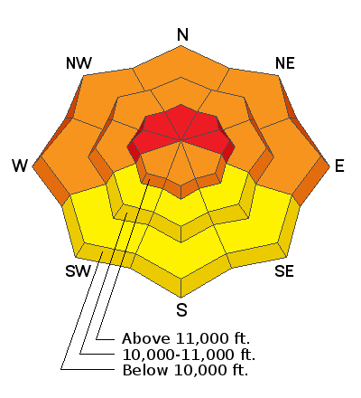
Blowing and drifting snow will cause the avalanche danger to rise to HIGH today in upper elevation, wind exposed terrain, particularly on slopes with a W-N-E aspect. Natural and human triggered avalanches are likely in these areas. At mid, and even lower elevations, the avalanche danger is CONSIDERABLE on steep, wind drifted slopes facing W-N-E, and human triggered avalanches are likely in these areas. Mid, and lower elevation, south facing terrain offers mostly MODERATE danger. Backcountry travelers today need to have excellent route finding skills and know how to stay off of, and out from under, avalanche prone terrain.
Low
Moderate
Considerable
High
Extreme
Learn how to read the forecast here
Special Announcements
We are sorry to report that a skier was buried and killed in a large avalanche around 5 pm Friday by Electric Lake, on the Manti/Skyline Plateau. Our sincere condolences go out to the victim's family and friends. Here is the accident report.
Grand County has not plowed since the most recent storm Thursday night. 4"-6" of rutted and drifted snow exists on the road. 4wd required.
We will be offering a Backcountry 101 avalanche course on Feb 8, 9. It's a great way to up your avalanche knowledge with both classroom, and hands on field instruction. Click here for more details and to register. Much thanks to Moab Gear Trader for sponsoring this course! Please visit them for all of your winter backcountry needs.
Weather and Snow
A fast moving storm system will sweep through the region today and into early Tuesday morning. Snow totals for our area don't look particularly impressive, up to around 6", but the real story is the wind. SW winds began ramping up yesterday afternoon blowing in the 25-30 mph range with gusts to 50. Around midnight they swung around to the SE where they have continued to blow in the same range. Strong southerly winds will continue throughout the day with developing periods of snow showers. It looks to me like 2"-4" are possible by late afternoon. High temps today will be in the low 20's. Windy and snowy conditions will continue into tonight with snow tapering off after midnight. Another 2"-4" are possible. Temps will plummet into the single digits overnight, and winds will shift to the NW creating bone chilling conditions, with mostly sunny skies on Tues.
I'm afraid the excellent conditions of the past few days have taken a turn. Winds are hammering the snow surface, and stiff drifts, slabs, and crusts will be forming in all exposed locations. Best bet for soft snow will be found in very sheltered, mid and lower elevations.
Charlie Ramser sent in this observation from yesterday, with his danger forecast for today. I'd say he's dead on.
Base depth in Gold Basin: 50"
New snow totals in Gold Basin (10,000')
Snow totals at the Geyser Pass Trailhead (9600')
Wind, temperature, and humidity on Pre Laurel Peak (11,700')
National Weather Service point forecast.
Recent Avalanches
It's been an active week for avalanche natural avalanche activity and numerous slides have been reported throughout the range. I'm working on a compiling a list, but a trip into Gold Basin revealed a widespread cycle with avalanches breaking 3' deep on W-N-E aspects. Talking Mountain Cirque was particularly affected. A wind drifted slope broke out up to 7' deep, and the floor of the entire basin was covered in debris. And an infrequently running slide path ran full track, depositing debris into a stand of mature trees.
Ad
Avalanche Problem #1
Persistent Weak Layer
Type
Location
Likelihood
Size
Description
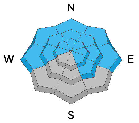
Blowing and drifting snow will continue to put pressure on buried persistent weak layers in the snowpack. Though outward signs of instability such as collapsing and whumphing are becoming less frequent, snow stability tests continue to show that the problem is alive and well. The danger is greatest on steep slopes facing W-N-E, and human triggered avalanches 3'-4' deep remain likely in these areas.
Avalanche Problem #2
Wind Drifted Snow
Type
Location
Likelihood
Size
Description
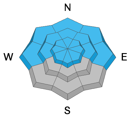
Plenty of loose snow is around and available for transport, and blowing and drifting snow will rapidly increase the avalanche danger today. Look for fresh drifts forming on the lee sides of ridge crests and terrain features such as gully walls, sub-ridges, and rock outcroppings. Today's winds will penetrate everywhere. In addition, new wind slabs will overly old in many areas and may be connected to much wider terrain than you realize. And finally, triggered wind slabs have the potential to step down into buried, persistent weak layers, creating a much deeper, and even more dangerous avalanches.
Additional Information
Grooming: Trails were groomed on Saturday.
General Announcements
Your information can save lives. If you see anything we should know about, please help us out by submitting snow and avalanche observations HERE. You can also call me at 801-647-8896, or send me an email: [email protected].
Support the UAC through your daily shopping. When you shop at Smith's, or online at REI, Backcountry.com, Patagonia, NRS, Amazon, eBay by clicking on these links, they donate a portion of your purchase to the UAC. If you sell on eBay, you can have your See our Affiliate Page for more details on how you can support the UAC when you shop
This advisory is from the U.S.D.A. Forest Service, which is solely responsible for its content. This advisory describes general avalanche conditions and local variations always occur.