Forecast for the Logan Area Mountains

Sunday morning, March 4, 2018
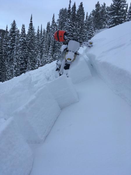
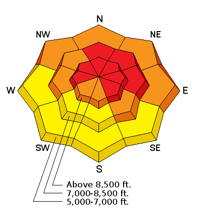
Dangerous avalanche conditions exist in drifted terrain, and periods of heavy snowfall and continued drifting from strong west wind will cause the danger to rise further today. The danger may rise to HIGH, with dangerous natural and human triggered avalanches becoming likely.
- Avoid travel in backcountry avalanche terrain today.
- Stay off and out from under slopes steeper than about 30 degrees, and well clear of obvious or historic avalanche paths.
 Weather and Snow
The well advertised winter storm is finally here, and the Winter Storm Warning for our area will continue into tonight. Snowfall will be heavy at times, and significant drifting will occur, with westerly winds 35 to 45 mph gusting to 75 mph on the high ridges. (forecast wind speed increase updated at 11:00)
Dangerous avalanche conditions exist at upper elevations this morning, and today's storm will likely cause the danger to rise to HIGH in drifted terrain, with natural and human triggered avalanches becoming likely. People should avoid travel in backcountry avalanche terrain today.
- It's hard to figure out how much and where snow fell overnight. There's at least 6", and perhaps more on my walk in Logan this morning, but only one or two inches fell in the Central Bear River Range, with no new SWE showing up at the Tony Grove Snotel.
- The Tony Grove Snotel at 8400' reports 16°F, and there's 75 inches of total snow, with 85% of normal snow water equivalent.
- It's 16°F on at the UDOT Hwy 89 Logan Summit this morning, and the wind is blowing 10 to 15 mph from the northwest, with gusts around 20 mph.
 Recent Avalanches
Two reports of avalanches observed Wednesday. Both likely failed on a persistent weak layer consisting of faceted snow and rain-crust.
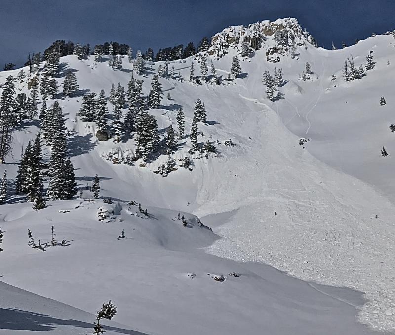
- A natural avalanche observed Wednesday morning, 2 to 3' deep and around 250' wide persistent (wind) slab, running 600 vrt'', on the east face of Magog in Tony Grove Area, likely triggered by cornice fall overnight.
- Unintentional snow-bike triggered avalanche, 2 to 3' deep and around 200' wide, East facing slope, 8500' elevation, in Copenhagen Basin, near Emigration Summit in SE Idaho.
Wind Drifted Snow
Description
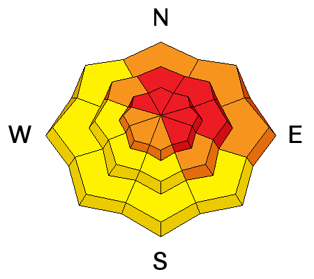
Natural and human triggered avalanches and cornice falls are likely today in steep drifted terrain.
- Watch for and avoid drifted snow in and around terrain features like cliff bands, gullies, scoops, and sub-ridges.
- Wind slabs will be found on the lee side of major ridges, on slopes below cornices, in saddles, and downwind of open fetch areas.
- Avoid ridge-top cornices, which often break further back than expected and can trigger avalanches on drifted slopes below.
- In some cases thick drifts formed on slopes with poor snow structure, and some wind slab avalanches could step down to buried weak faceted layers.
Persistent Weak Layer
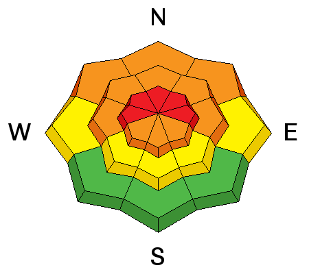
Description
Dangerous persistent slab avalanche conditions exist, especially on slopes with shallow overall snow cover. We've found shallow snow and poor snow structure recently in shady, mid-elevation, forested, and windward terrain, with particularly eye-opening test results on west and north facing slopes. Buried layers of weak faceted snow near the ground and on either side of rain-crusts from late January and early February are suspect. Human triggered and natural avalanches up to around 3-feet-deep, stepping down into buried persistent weak layers are likely.
- Avoid steep rocky slopes with shallow snow cover and poor snow structure.
- Avalanches might be remote triggered, from a distance or below.
- Cracking and collapsing or whumpfing are red flags indicating unstable snow.
Weak layers made up of well developed sugary facets are widespread in shallow snow in the backcountry around Beaver Mt.
Additional Information
A potent upper level storm system will cross the entire region today but linger across the north into tonight. High pressure will follow for most of next week.
- Today: Snow before 11am, then snow showers after 11am. The snow could be heavy at times. High near 18. Wind chill values as low as -10. Windy, with a west wind 23 to 33 mph, with gusts as high as 47 mph. Chance of precipitation is 100%. Total daytime snow accumulation of 6 to 10 inches possible.
- Tonight: Snow showers likely, mainly before 11pm. Cloudy, with a low around 8. Wind chill values as low as -10. Windy, with a west northwest wind 26 to 31 mph decreasing to 17 to 22 mph after midnight. Winds could gust as high as 45 mph. Chance of precipitation is 70%. New snow accumulation of 1 to 3 inches possible.
- Monday: A 20 percent chance of snow showers before 11am. Mostly cloudy, with a high near 17. Wind chill values as low as -10. West wind around 17 mph.
General Announcements
Episode 6 of the UAC podcast "A Conversation with Tom Kimbrough, Hemingway of the Wasatch" is live. We explore ideas about lifetime exposure to risk and what role Buddhism has played in his life as a climber, skier, and soon-to-be octogenarian. We talk about what has changed over the years in snow science and the role of mentorship in the world of avalanche forecasting and other professions and pursuits. Check it out on ITunes, Stitcher, the UAC blog.
We have discount lift tickets for Alta, Snowbird, Brighton, Solitude, Snowbasin,and Beaver Mountain. Details and order information here. All proceeds from your purchase go towards paying for avalanche forecasting and education.
Episode 5 of the UAC podcast To Hell in a Heartbeat - A Conversation With Tom Diegel and Matt Clevenger About the 12.26.08 Full Burial on Little Water is live. This podcast talks with Matt and Tom about their experience and the massive success of the To Hell in a Heartbeat video which has been viewed almost 3M times. Check it out on ITunes, Stitcher, the UAC blog, or wherever you get your podcasts.
The UAC Marketplace is online. The holiday auction is closed, but our online marketplace still has deals on skis, packs, airbag packs, beacons, snowshoes, soft goods and much more.
The UAC has new support programs with Outdoor Research and Darn Tough. Support the UAC through your daily shopping. When you shop at Smith's, or online at Outdoor Research, REI, Backcountry.com, Darn Tough, Patagonia, NRS, Amazon, eBay a portion of your purchase will be donated to the FUAC. See our Donate Page for more details on how you can support the UAC when you shop.
Benefit the Utah Avalanche Center when you buy or sell on eBay - set the Utah Avalanche Center as a favorite non-profit in your eBay account here and click on eBay gives when you buy or sell. You can choose to have your seller fees donated to the UAC, which doesn't cost you a penny Check it out on ITunes, Stitcher, the UAC blog, or wherever you get your podcasts.
Now is a great time to practice companion rescue techniques with your backcountry partners. Here's our rescue practice video.
EMAIL ADVISORY: If you would like to get the daily advisory by email you will need to subscribe here.
Remember your information can save lives. If you see anything we should know about, please help us out by submitting snow and avalanche observations. You can also call us at 801-524-5304, email by clicking HERE, or include #utavy in your Instagram.
This advisory is from the U.S.D.A. Forest Service, which is solely responsible for its content. This advisory describes general avalanche conditions and local variations always occur.


