Forecast for the Skyline Area Mountains

Brett Kobernik
Issued by Brett Kobernik for
Monday, February 12, 2018

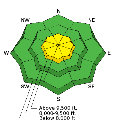
The majority of the terrain along the Skyline has a LOW avalanche danger. There is a scattered MODERATE avalanche danger in the upper elevations where the wind has drifted the new snow into slabs. These alone don't pose much threat unless they happen to break into old weak snow near the ground. The most likely places for this to happen is on northwest through east facing steep slopes above about 9500' in elevation.

Low
Moderate
Considerable
High
Extreme
Learn how to read the forecast here
Weather and Snow

For some details on the recent new snow and minor avalanche activity CHECK OUT THIS BACKCOUNTRY OBSERVATION FROM SUNDAY, FEB 11TH.

Ad
Additional Information

General Announcements

Support the Utah Avalanche Center through your everyday shopping. DETAILS HERE

We will publish full detailed advisories Saturday and Sunday mornings by 7am. We will also be publishing basic avalanche danger ratings & info during the week.

If you are getting out into the mountains, we love to hear from you! You can SUBMIT OBSERVATIONS ONLINE or EMAIL US

If you would like to have avalanche advisories emailed to you, SIGN UP HERE

We can provide basic avalanche awareness presentations for your school, group or club. To enquire, CLICK HERE