Episode 2 of the UAC podcast has been released. Drew Hardesty talks Avalanche Weather with Professor Powder himself, atmospheric sciences professor and author of Secrets of the Greatest Snow on Earth, Jim Steenburgh. Check it out on ITunes, Stitcher, the UAC blog, or wherever you get your podcasts.
This morning temperatures are in the mid 30's F. Winds are averaging 10-15 mph gusting 20-25 mph from the SSW. On shaded aspects the thin snowpack continues to weaken and facet. On SW, S, and SE aspects, the snow surface has become damp during the last few days and refrozen at night.
Week in Review
[Click HERE for a more detailed report]
Friday December 29: A skier-triggered avalanche occurred in Dry Fork. This avalanche was 2.5' deep and 100' wide, running 400' vertical. It was a persistent slab avalanche, failing in faceted snow that formed during the earlier part of the winter.
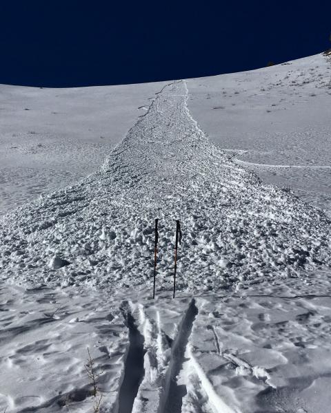
Saturday December 30 - Thursday January 4: Our continued pattern of no storms with mostly clear skies. Moderate west/northwest winds were observed, particularly early in the week, but they only produced small pockets of unresponsive wind-slabs. Observers reported continued collapsing in the snowpack, but collapses were much less common than over the week between Christmas and New Years. The clear skies have helped to weaken the snowpack, especially at the surface.
The one notable thing has been sluffing of the surface snow which is an indication of how weak and faceted it has become. See the photo (M. White) below of a long running sluff along the Park City Ridgeline. While not a major concern now, it is a heads up once snow accumulates on top of it. The snow surface has been similarly weakening in the Provo area mountains.