


Forecast for the Ogden Area Mountains

Monday morning, November 27, 2017
The avalanche hazard is LOW. A few sluffs are possible. On the highest upper elevation northwest through northeast aspects in the Ogden area mountains, there could be lingering weak faceted snow in isolated places near the ground, which could create a very isolated persistent slab hazard. Remember - a low avalanche hazard doesn't mean no avalanches.
We will continue with intermittent advisories until we begin to receive more snow.
 Special Announcements
Unopened ski area terrain has a backcountry snowpack, as avalanche mitigation work has not been done. Each resort has different uphill travel policies - please abide by signage and closures and check in with the local ski patrol.
 Weather and Snow
The Monday "storm" was basically a non-event. Scouring the remote weather stations, I was hard pressed to find more than an inch of snow in the mountains - perhaps 2" on Ben Lomond? So now it's dust on crust conditions. On the plus side, temperatures have plummeted from the 50s into more wintery 20s and 30s. The strong, southwesterly winds that were averaging 30 to 40 mph Monday have switched to the northwest and decreased into the 10 to 20 mph.
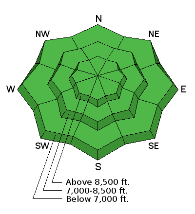
A rain event to the tops of the ridge lines early last week, along with very warm temperatures over the Thanksgiving holiday, have crusted most snow surfaces. These crusts will freeze solid, and "slide for life" conditions could exist on steep slopes. Southerly through westerly aspects have melted off, with patches of snow clinging to northerly aspects above about 8500' - about 12" of snow or a bit more.
At the bottom of this observation are a few photos of snow coverage I took Sunday.
 Recent Avalanches
There has been no reported recent avalanche activity in the Ogden area mountains.

Normal Caution
Description
The snowpack is currently stable and avalanches are unlikely. However:, a few shallow sluffs could be triggered in wind drifted areas, running on the slick crusts. Although these would be quite shallow, even a short ride or slip on our thin snowpack will mean a ride over rocks and stumps.
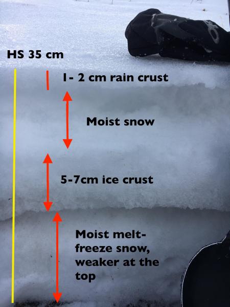
Here is a look at the "snowpack" on a northerly facing slope, 8800', from Sunday. Lots of variability over short distances in the shallow, Ogden area snowpack.
Additional Information
Clouds will decrease overnight, with sunny skies and cooler temperatures expected by Tuesday. The next chance for any snow will be Wednesday, though much of the model guidance keeps this storm north of the area with only a few isolated showers possible. Another potential storm is in the computer models for this coming weekend, with a better chance for accumulating snow.
General Announcements
|
Remember your information can save lives. If you see anything we should know about, please help us out by submitting snow and avalanche conditions. You can also call us at 801-524-5304, email by clicking HERE, or include #utavy in your tweet or Instagram. To get help in an emergency (to request a rescue) in the Wasatch, call 911. If you trigger an avalanche in the backcountry, but no one is hurt and you do not need assistance, please notify the nearest ski area dispatch to avoid a needless response by rescue teams. Thanks.
Utah Avalanche Center mobile app - Get your advisory on your iPhone along with great navigation and rescue tools. To those skinning uphill at resorts: it is critical to know the resort policy on uphill travel. You can see the uphill travel policy for each resort here. Support the UAC through your daily shopping. When you shop at Smith's, or online at REI, Backcountry.com, Patagonia, NRS, Amazon, eBay by clicking on these links, they donate a portion of your purchase to the FUAC. If you sell on eBay, you can have your See our Donate Page for more details on how you can support the UAC when you shop. Benefit the Utah Avalanche Center when you buy or sell on ebay - set the Utah Avalanche Center as a favorite non-profit in your ebay account here and click on ebay gives when you buy or sell. You can choose to have your seller fees donated to the UAC, which doesn't cost you a penny. This information does not apply to developed ski areas or highways where avalanche control is normally done. This advisory is from the U.S.D.A. Forest Service, which is solely responsible for its content. This advisory describes general avalanche conditions and local variations always occur. |