Forecast for the Skyline Area Mountains

Sunday morning, January 1, 2017
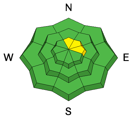
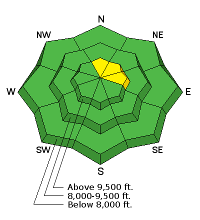
The avalanche danger is generally LOW in the majority of the terrain. There is a "pockety" MODERATE avalanche danger along the higher more east facing steep terrain where isolated wind drifts could be triggered by a person. If you are getting into steep terrain, only put one person on the slope at a time and make sure everyone is clear of the avalanche run-out zone at the bottom.

Weather and Snow
It was another great day up in the hills on Saturday with light wind and plenty of sun. Snow conditions are a mixed bag but there is still great snow for riding out of the wind and sun effected terrain.
During my travels over the last few days I've been finding more weak snow that has formed on the snow surface than I like to see. This is not an avalanche concern for today but could be once we add more snow with the upcoming anticipated storms early next week. I'm not 100% sure this weak surface snow will cause problems once it's buried but it's something to have on your radar. Check the observation below for more details on this weak layer:
Skyline | 12/31/2016 | Observation: Skyline | Brett Kobernik | Details |
Recent Avalanches
Below is a photo of a cornice failure reported on Saturday. This demonstrates the type of isolated avalanche concern that is out there right now.
Skyline | 12/31/2016 | Avalanche: Big Drift/Skyline Summit | Stan Torgersen and Evan Matheson | Details |
Normal Caution


Description
Wind slabs that formed during the past week seem very stubborn at this point and it is unlikely that a person will trigger them. However, in the very steepest terrain there is still a remote chance that one of these could release on you. They are most likely on the lee sides of the ridges that face north through east.
Additional Information
It looks like not too bad of a day ahead today with partly cloudy skies, ridgetop temperatures in the mid 20s and light to moderate speed southwest wind. The wind will probably increase a bit later today. The long range looks rather stormy. We'll see the first in a series of storms start late Sunday night and we could see 6 to 10" by mid day Tuesday. Temperatures are going to drop into the low teens and perhaps single digits and remain cold for much of the week. It looks like wind will be moderate to strong from the west southwest for much of the week. We should see continued periods of snow from Wednesday on through the weekend.
General Announcements
We will publish full detailed advisories Saturday and Sunday mornings by 7am. We will also be publishing basic avalanche danger ratings & info during the week.
If you are getting out into the mountains, we love to hear from you! You can SUBMIT OBSERVATIONS ONLINE or EMAIL US
If you would like to have avalanche advisories emailed to you, SIGN UP HERE
We can provide basic avalanche awareness presentations for your school, group or club. To enquire, CLICK HERE