Cruised the Park City ridgeline early this morning. Had hoped to look at both the No Name slide as well as Squaretop, but only was able to visit No Name.
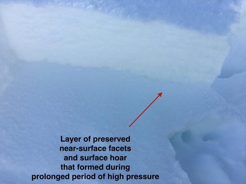
Slide was larger than expected - 250' wide. It was a storm slab that failed on a layer of NSF and SH that formed over the prolonged period of high pressure and was preserved under the dense snow from late this past weekend. The original observation was excellent. This slope was a repeater and there was less than 1 meter of snow in the starting zone, with even lesser amounts lower down the path. In some places I was sinking down to the ground in faceted snow. It was a shallow slide - accurately reported as 6-12" (15-30 cms) but broke out wide and ran full track. It looks like the slide originally failed at the old snow/new snow interface (down 15 cms), but also stepped down to a weaker layer 30 cms down. I did several CT and ECT at the crown and could not get the ECT to propagate. Am guessing any storm slabs have settled out by now (which is expected.)
Although I was not able to look at the Squaretop slide, I was able to get in touch with the observer who reported it and it too sounds as if it failed on a layer of faceted snow. This was a wind slab that formed from the very strong winds on Sunday & Monday.
The take home for me is that one current avalanche problem remains on slopes with thinner snowpacks, especially those that have already slid this season. Whereas I would have no problem today skiing something steep on a shady aspect in upper LCC (for example), I would stay away from the steeper slopes on the typically weak PC ridgeline (for example.)
Otherwise only concern going forward is how the snowpack reacts to this current warmup.
I would guess the hazard is Low on most slopes, with Moderate on solar aspects, as well as all lower elevation aspects. I also think the hazard is Moderate on northerly aspects - particularly through Northeast - that have thinner & weaker snowpacks such as the PC ridgeline.
Photos of crown at No Name Bowl showing the two obvious layers of preserved weak, faceted snow. Quick video discussion of the slide as well.