Join us at our 2nd Annual Blizzard Ball

Forecast for the Uintas Area Mountains

Craig Gordon
Issued by Craig Gordon on
Wednesday morning, February 3, 2016

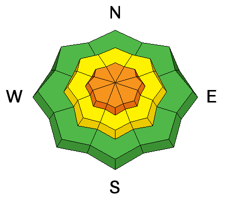
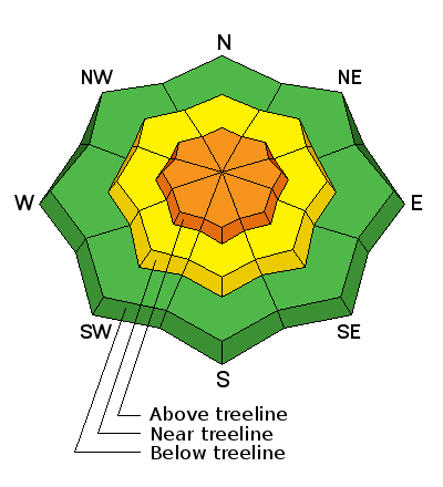
At and above treeline, especially in the wind zone, the avalanche danger is CONSIDERABLE and human triggered avalanches are likely on steep, wind drifted slopes. Any avalanche that breaks to weak, sugary snow near the ground has the potential to be deep and dangerous.

Mid elevation terrain offers a MODERATE avalanche danger and human triggered avalanches are possible on steep slopes with recent deposits of wind drifted snow.

Looking for LOW avalanche danger? Head to low elevation, wind sheltered terrain.

Low
Moderate
Considerable
High
Extreme
Learn how to read the forecast here
Special Announcements

Sad avalanche news to report from the Park City area where Stephen Jones was found yesterday afternoon after he went missing late Sunday. Our collective thoughts, prayers, and energy go out to Stephan's friends and family. A preliminary report is found here.

Weather and Snow

A weak storm is sliding through the region this morning and a few flurries are falling under partly cloudy skies. It's cold with temperatures near zero. Along the high ridges northwest winds are blowing 15-25 mph producing wind chill values near -30 degrees. You're gonna have to get creative today to find snow that isn't wind jacked. Mid and low elevation, wind sheltered terrain is the ticket.

Trip reports and observations are found here.

Recent Avalanches

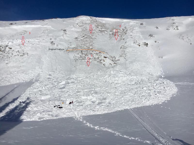
This slide below from Sunday captures the essence of what we're dealing with.
It's pretty clear from this image above... two distinct avalanche problems. Recent wind drifts and of course our problem child, deeper buried weak layers.
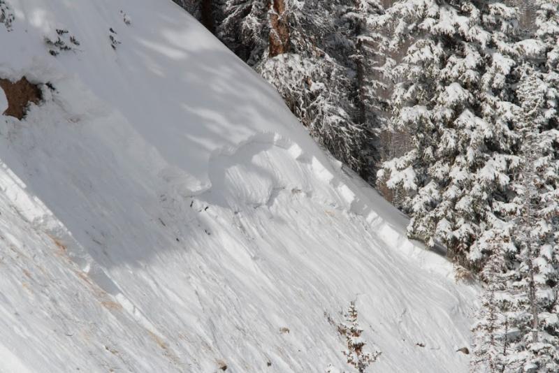
This "repeater" slide in Upper Weber Canyon, broke to old snow near the ground Sunday and was triggered from the top of slope on a steep Northeast facing slope. (Deutschlander photo)

Recent avalanche observations are found here.

See or trigger an avalanche? Shooting cracks? Hear a collapse? It's simple. Go here to fill out an observation.

Ad
Avalanche Problem #1
Wind Drifted Snow
Type
Location
Likelihood
Size
Description

Winds have been all over the place the past few days and I expect you'll find hard, stubborn slabs in unusual terrain features, particularly around gullies, chutes, and sub-ridges. While today's slabs have settled out somewhat, they still have the potential to break deeper and wider than you might expect. Easy to detect by their fat rounded appearance, I'd avoid any steep, wind drifted slope today especially if the snow feels or sounds hollow like a drum.

Avalanche Problem #2
Persistent Weak Layer
Type
Location
Likelihood
Size
Description

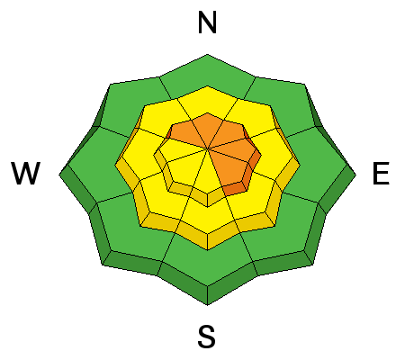
While both new and old wind drifts are today's most obvious and straight-forward avalanche problem, don't get complacent thinking this is the only avalanche dragon out there. As a matter of fact, more dangerous and less predictable, is any slide that breaks to weak layers of snow near the ground. The most likely terrain to trigger a deep, dangerous slide are steep slopes facing the north half of the compass, particularly those that avalanched big during the Solstice Storm.

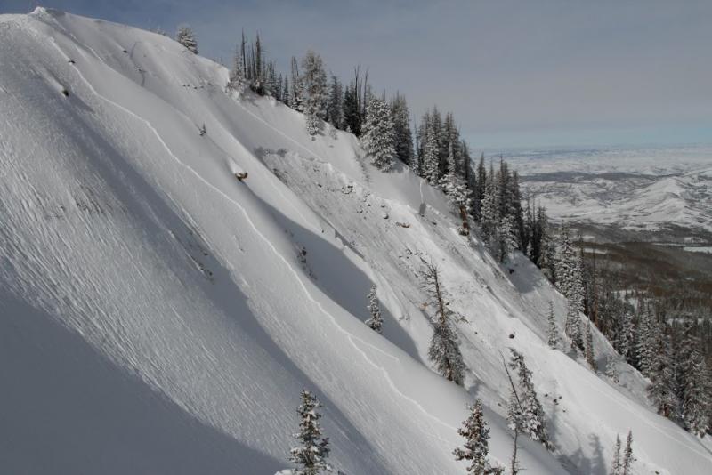
Sled triggered slide from last Thursday, clearly shows how we can initiate a deep, scary avalanche from low on the slope.

Additional Information

A weak disturbance moving across southwest Wyoming brings scattered snow showers to the region, mainly this morning. It'll be cold, with high temperatures only rising into the mid teens and overnight lows near zero. West and northwest winds blow in the 20's and 30's along the high ridges. Winds shift to the southwest tonight ahead of a weak system that'll give us light snow overnight. Scattered snow showers for Thursday and then high pressure and warming temperatures are on tap for Friday into the weekend.

General Announcements

Remember your information can save lives. If you see anything we should know about, please participate in the creation of our own community avalanche advisory by submitting snow and avalanche conditions. You can call me directly at 801-231-2170, email [email protected], or email by clicking HERE

This is a great time of year to schedule a free avalanche awareness presentation for your group or club. You can contact me at 801-231-2170 or email [email protected]. To register for the first in our series of on-the-snow sled specific classes you can register here.

The information in this advisory is from the US Forest Service which is solely responsible for its content. This advisory describes general avalanche conditions and local variations always occur.

The information in this advisory expires 24 hours after the date and time posted, but be will be updated by 7:00 AM on Thursday, February 4th.