


Forecast for the Logan Area Mountains

Monday morning, April 15, 2013
We're done for the season and no danger ratings are available, but you should check the Salt Lake Area Advisory for intermittent spring weather and avalanche conditions updates.. Thanks for your interest in local avalanche conditions, and your support....
 Recent Avalanches
Here is the preliminary report on Thursday's tragic and fatal avalanche accident in Big Cottonwood Canyon in the salt Lake Area Mountains, which killed friend and fellow avalanche forecaster, Craig Patterson. The deadly wind slab avalanche wasn't all that big, but it took him down for a very nasty ride in steep terrain. ......... Here
No significant new avalanches were reported recently in the Logan Area.....,
Here's a picture of this season's contender for scariest avalanche in the Logan Area....... February 3, 2013, South Tony Grove Lake Area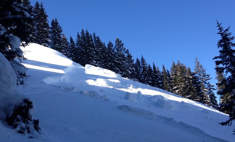
Here's a link to our season's Avalanche List.

Persistent Weak Layer
Description
- Strong and sustained northwest winds overnight formed stiffer wind slabs with fresh snow in deposition zones at upper elevations.
- Triggered wind slab avalanches, up to around a foot deep are possible in drifted upper elevation terrain. These could be fairly sensitive today, and will likely pick up speed in steep terrain and run fast on slick underlying crust.
- Watch for and avoid stiffer snow and fresh drifts on the lee of major ridges and in and around terrain features like sub-ridges, rock bands, and gullies.
- Recently built-up cornices are also a concern, as they could be fairly sensitive today, might break further back than you expect, and could trigger wind slab avalanches on slopes below.
Wet Snow
Description
Wet and heat related avalanches will continue to be of concern when temperatures rise with high sun angles initially after fresh snow, and again at upper elevations during periods with prolonged warm temperatures and poor overnight freezes.....
As usual, it's a good idea in the spring to ride early and leave steep terrain before temperatures warm up and the snow becomes soft and saturated.
Additional Information
Check out the Logan Mountain Weather page...
General Announcements
For a printer friendly version of this advisory click HERE
A memorial service to celebrate the life of Craig Patterson will take place Thursday, April 18th at 10am at the Albion Grill, Alta. Photos of Craig are welcome. In lieu of gifts or flowers, please contribute to the Craig Patterson Memorial Fund at any Key Bank. Or checks can be sent to the Craig Patterson Memorial Fund 520 Crestview Dr Park City, UT 84098.
(http://
Remember your information from the backcountry can save lives. If you see or trigger an avalanche, or see anything else we should know about, please send us your snow and avalanche observations. You can also call us at 801-524-5304 or email by clicking HERE. In the Logan Area you can contact Toby Weed directly at 435-757-7578.
This advisory is produced by the U.S.D.A. Forest Service, which is solely responsible for its content. It describes only general avalanche conditions and local variations always exist.