Forecast for the Salt Lake Area Mountains

Monday morning, December 24, 2012
A mostly MODERATE danger may spike toward CONSIDERABLE today with heavy snowfall and we may see some shallow natural activity with any bump in wind or snowfall rates. Pockets of CONSIDERABLE danger for triggering deeper, more dangerous slides are most prevalent in drainages and elevations with a shallower snow pack depth. They are more pronounced, but not limited to the periphery of the Cottonwoods. These slides may be triggered at a distance.
 Special Announcements
It's never too late to give that special someone (or yourself) an avalanche class for the holidays. A couple of clicks and you are done - no standing in line or shipping. We have beginning and advanced 1 day classes, the Snowbird Freeride Avalanche Summit, and women-only classes. Details at http://utahavalanchecenter.
Discount lift tickets are in! Go to http://www.backcountry.com/utah-avalanche-center to get tickets from our partners at Beaver Mountain, Park City, Canyons, Snowbird, Sundance, and Wolf Mountain. All proceeds benefit the Utah Avalanche Center. A big thanks to the Utah mountain resorts - we couldn't do it without your partnership.
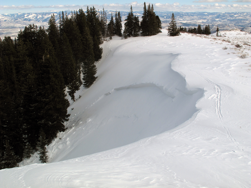
A quick word on dropping cornices. Drop cornices only when you are sure no one is below you. If the visibility is poor, it's a no-go. The same goes for ski/slope cutting. Dropping cornices from above into ski resort terrain - as was the case a couple of days ago - is a bad move.
 Weather and Snow
The first of two storms this week has already arrived and it didn't ask politely. I've already heard "dumping" and "puking" to affectionately describe the morning's snowfall. Most areas along the Wasatch have 4-6" so far...and it's gonna snow all day. Winds are westerly at 10-15 mph with gusts to 20. Temps are in the upper teens...though the bottom should fall out after frontal passage early afternoon. They'll drop to the single digits by tonight.
 Recent Avalanches
Timing of these is uncertain, but reports came in of 2-3 natural slab avalanches near Murdock Peak in upper Lambs Canyon. (pic below Paul Daugherty) Found on steep north to east facing slopes at 9400', these avalanches were reported to be 1-2' deep and 50- 100' wide, likely triggered by the last gasp of the 4 day Solstice Wind Event. Good riddance. Another, more disconcerting natural - or perhaps remotely triggered slide - was found off the Benson/Reed ridgeline in upper Cardiff Fork of Big Cottonwood. This hard slab was reported to be 4' deep and 35' wide pulling out on a very steep westerly facing aspect at 9700'. And...just to keep us on our toes, the shallow but layered snowpack near Big Water Peak above Mill Creek collapsed and propagated widely - though didn't run - on a northeast facing slope at 8500'. Lastly, control work in upper BCC produced one slide that pulled into old snow 3' deep and 80' wide on steep northerly slope at 10,500'.
Murdock?/Benson Reed?/Lambs? You know the old joke - "The French, they have a word for everything." Same for the Wasatch. Check out Steve Achelis's website (http://wasatchbackcountryskiing.com/) to get clued in. His weather-resistant field map can be found at our store (up top on the header) or at many fine stores near you. Shameless plug - they make great stocking stuffers and proceeds benefit the Friends of the Utah Avalanche Center. Thanks Steve!
New Snow
Description
The initial concern for today will be in the storm snow. We're expecting roughly 8-14" today...but that's not the key. The key is how much how fast - and this refers to precipitation intensity. Snowfall rates this afternoon are expected to bump to 2+"/hr - and may be enough for both storm snow slabs and loose snow sluffs to release naturally. Keep this in your back pocket for terrain choices for today. Steep, exposed, no-fall terrain with severe consequences below may be a poor choice. Storm and loose snow avalanches are manageable for pros, but when naturals are occurring and you're committed to, say, the south face of Superior, you'll be on the wrong end of the gun.
New Snow
Description
The persistent slab problem is most pronounced along the periphery of the Cottonwoods, places that harbor a thin snowpack, and has seen some of the wind affect from the Solstice Wind Storms of 2012. Murdock is a perfect example. My own collapsing in upper Mill Creek is another. It's why most of my concern centers on the Manti-Skyline Plateau, the western Uintas, and -as before - the periphery of the Cottonwoods. Collapsing, remote triggering, all these remain possible today.
Experienced pros and backcountry riders can manage loose and storm snow avalanches through safe cornice drops, slope cuts, and smart terrain choices. Persistent hard slabs? Nope. The only ticket here is lots of homework, smart terrain choices, or avoidance. You'll be able to find excellent turns on mid and upper elevation slopes less steep than 35 degrees (with nothing steeper above).
Wet Snow
Description
I expect the new snow to move with - and perhaps without - provocation during periods of high rates of snowfall today. Spatial variation is less of a factor as temporal variation.
Additional Information
Should storm all day, with higher snowfall rates during the early afternoon with frontal passage. We'll have temps in the low 20s and upper teens, dropping to the low single digits by tonight into tomorrow. Christmas Day should offer clearing skies, light wind and a foot or more of fresh snow from today's storm. The next, longer storm event commences Wednesday, lasting through perhaps early Friday where we could see another 12-18".
General Announcements
Go to http://www.backcountry.com/utah-avalanche-center to get tickets from our partners at Ala, Beaver Mountain, Brighton, Canyons, Deer Valley, Park City, Powder Mountain, Snowbasin, Snowbird, Solitude, Sundance, and Wolf Mountain. All proceeds benefit the Utah Avalanche Center.
If you trigger an avalanche in the backcountry - especially if you are adjacent to a ski area – please call the following teams to alert them to the slide and whether anyone is missing or not. Rescue teams can be exposed to significant hazard when responding to avalanches, and do not want to do so when unneeded. Thanks.
Salt Lake and Park City – Alta Central (801-742-2033), Canyons Resort Dispatch (435-615-3322)
Ogden – Snowbasin Patrol Dispatch (801-620-1017)
Powder Mountain Ski Patrol Dispatch (801-745-3773 ex 123)
Provo – Sundance Patrol Dispatch (801-223-4150)
Dawn Patrol Forecast Hotline, updated by 05:30: 888-999-4019 option 8.
Twitter Updates for your mobile phone - DETAILS
Daily observations are frequently posted by 10 pm each evening.
Subscribe to the daily avalanche advisory e-mail click HERE.
UDOT canyon closures UDOT at (801) 975-4838
Wasatch Powderbird Guides does daily updates about where they'll be operating on this blog http://powderbird.blogspot.com/ .
Remember your information can save lives. If you see anything we should know about, please participate in the creation of our own community avalanche advisory bysubmitting snow and avalanche conditions. You can also call us at 801-524-5304 or 800-662-4140, or email by clicking HERE
Donate to your favorite non-profit –The Friends of the Utah Avalanche Center. The UAC depends on contributions from users like you to support our work.
For a print version of this advisory click HERE.
This advisory is produced by the U.S. Forest Service, which is solely responsible for its content. It describes only general avalanche conditions and local variations always exist. Specific terrain and route finding decisions should always be based on skills learned in a field-based avalanche class.


