


Forecast for the Salt Lake Area Mountains

Wednesday morning, December 12, 2012
Areas of CONSIDERABLE plague the mid and upper elevation northeast and east facing slopes today. Human triggered slides are possible in this terrain, and may be triggered at a distance. Collapsing is a great indicator of localized instability. Other tracks on the slope offer no assurance. Elsewhere, a MODERATE danger exists due to the continued and extensive wind drifting. The snowpack is starting to show its hand.
 Weather and Snow
Skies are partly to mostly cloudy this morning. Headlines, however, remain the winds. The southerly winds picked up last night and are blowing 35-40mph with some gusts into the 60s and 70s. It's not pretty. Temps hover in the upper teens to low 20s. Low to mid elevation south and west aspects suffered some sun-damage yesterday...but at least you can find bullet-proof hard wind damage in the open exposed alpine terrain. Best bets would be to hunt for mid elevation sheltered terrain below tree-line. Which - as it happens - is where the dragon lives these days - more below-
 Recent Avalanches
Two more reports of human triggered avalanches filtered in from yesterday.
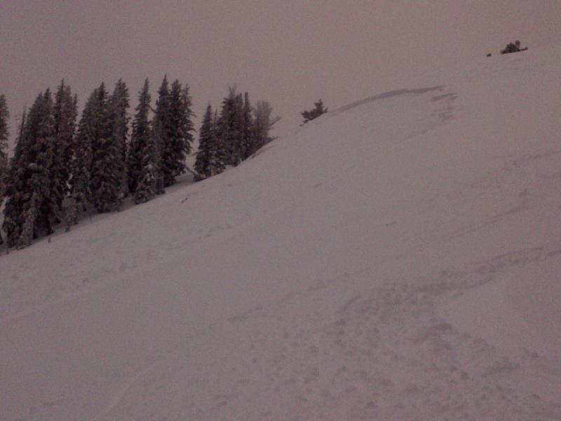
- McDonald Draw area along the Park City ridgeline. A party of three, while skiing lower angle terrain, collapsed the slope and remotely triggered a 2' deep and 100' wide avalanche on a steep northeast facing slope at 9700'. (M. Dawson photo below).
- From safe terrain, a Park City Mtn Resort Snow Safety team remotely triggered a large slide in uncompacted terrain near Jupiter Peak that pulled out 12-18" deep and 500' wide. This released not from explosives but from the additional weight of a team collapsing the slope. This was on a steep northeast facing slope at 9800'.
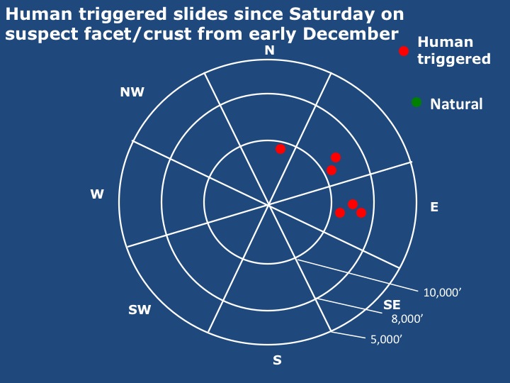
Since Saturday, we've heard of at least six human triggered slides on the suspect facet/crust layering formed the first week of December. Below is a aspect/elevation diagram depicting the pattern of the activity.
New Snow
Description
Blame global weirding. Our persistent slab problem is directly attributed to the arguably four- count 'em - four rain events since November 30. The limited snowfall between the events rapidly faceted and now we have a poor mid-pack structure from, say 8500' to where the rain-turned-to-snow, roughly 10,000' thereabouts. It has everything to do with those rain/snow lines. Above this elevation, it was all snow.
This explains the weak structure...and areas that have seen the most wind loading (northeast through southeast) - along with the weight of a person - are producing avalanches in the backcountry. It's what we call "collapse failure" and allows you to trigger avalanches from a distance. Unmanageable. Unpredictable. It'll be critical to watch the slope angles of not only terrain you're on, but what is above. Don't pull the thing down on top of you.
Hard slabs over facet crust combos warrant extreme caution. Terrain choices mean everything today.
Persistent Weak Layer
Description
Hard and soft wind drifts will be found in a wide variety of areas...and may be increasing stubborn with the continued loading today. Remember - soft slab - you're in the slab....hard slab - you're on top of the slab. Hard slabs are notorious for allowing you to get well out onto the whale's back before it shatters.
Additional Information
We'll have partly to mostly cloudy skies today with moderate to strong southerly winds along the ridgelines. Expect sustained speeds of 30mph with gusts to 50. Temps will be in the low 20s. A splitting system off to the west will keep us in a south to southwesterly flow through the next couple of days until it ejects inland and brings abundant moisture...to southern and central Utah. More unsettled weather and snow is likely over the weekend and into next week. More with our Mountain Weather update later.
General Announcements
If you trigger an avalanche in the backcountry - especially if you are adjacent to a ski area – please call the following teams to alert them to the slide and whether anyone is missing or not. Rescue teams can be exposed to significant hazard when responding to avalanches, and do not want to do so when unneeded. Thanks.
Salt Lake and Park City – Alta Central (801-742-2033), Canyons Resort Dispatch (435-615-3322)
Ogden – Snowbasin Patrol Dispatch (801-620-1017)
Provo – Sundance Patrol Dispatch (801-223-4150)
Dawn Patrol Forecast Hotline, updated by 05:30: 888-999-4019 option 8.
Twitter Updates for your mobile phone - DETAILS
Daily observations are frequently posted by 10 pm each evening.
Subscribe to the daily avalanche advisory e-mail click HERE.
UDOT canyon closures UDOT at (801) 975-4838
Wasatch Powderbird Guides does daily updates about where they'll be operating on this blog http://powderbird.blogspot.com/ .
Remember your information can save lives. If you see anything we should know about, please participate in the creation of our own community avalanche advisory bysubmitting snow and avalanche conditions. You can also call us at 801-524-5304 or 800-662-4140, or email by clicking HERE
Donate to your favorite non-profit –The Friends of the Utah Avalanche Center. The UAC depends on contributions from users like you to support our work.
This advisory is produced by the U.S. Forest Service, which is solely responsible for its content. It describes only general avalanche conditions and local variations always exist. Specific terrain and route finding decisions should always be based on skills learned in a field-based avalanche class.