UDOT PLANNED AVALANCHE CLOSURES!!

Forecast for the Uintas Area Mountains

Mark Staples
Issued by Mark Staples for
Sunday, April 23, 2023
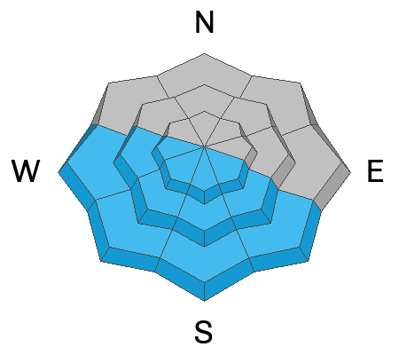
Today the avalanche danger is MODERATE above treeline on wind-loaded slopes.
The danger is also MODERATE on south and west facing slopes where the new snow will heat up quickly and produce shallow, wet loose avalanches.
Slopes without wind loading facing north and east will have a LOW danger.
As the sun heats up snow on houses and cabins in the mountains, stay away from roof edges where roof avalanches could be possible.
Low
Moderate
Considerable
High
Extreme
Learn how to read the forecast here
Special Announcements
Today is the last regular forecast. We will provide intermittent updates with any storm until Sunday, May 7th and will continue posting backcountry observations until then.
Weather and Snow
The last five days have been generally cold, with little sun, and on/off snowfall stacking up 10-12 inches of snow on the north slope as my partners and I found near Hayden Peak yesterday. There is less snow as you move south in the range. The strongest winds blew Friday 30-40 mph from the west at upper elevations for about 24 hours and hitting 60 mph for about 4 hours.
Today, this pattern will change and the weather will be clear, calm, and sunny as a brief ridge of high pressure moves over Utah.
Temperatures are in the mid teens F this morning and should warm today hitting the mid 30s to low 40s this afternoon.
Winds will be calm
Skies will be clear with strong sunshine that will heat up the snow very quickly
Recent Avalanches
Yesterday in the Whitney Basin, Ted found some very small slabs of wind drifted snow that had released. The last wet avalanches occurred during sunny weather last weekend.
Ad
Avalanche Problem #1
Wind Drifted Snow
Type
Location
Likelihood
Size
Description
At upper elevations above treeline, Friday's west-northwest winds drifted the new snow and formed slabs 1-2 feet deep mostly on the north slope which received the most snow last week. Wind slabs will be shallower in other areas. They should be less sensitive today.
Avalanche Problem #2
Wet Snow
Type
Location
Likelihood
Size
Description
Despite cold temperatures this morning, strong sunshine will quickly heat up the snow. As it becomes wet, expect to see shallow wet loose avalanches mostly on south and east facing slopes. Theses wet slides will easily run on top of the old, hard icy snow underneath.
General Announcements
This forecast is from the U.S.D.A. Forest Service, which is solely responsible for its content. This forecast describes general avalanche conditions and local variations always occur.