Forecast for the Uintas Area Mountains

Craig Gordon
Issued by Craig Gordon for
Sunday, April 17, 2022
Today you'll find MODERATE avalanche danger on leeward slopes, especially above treeline, in the wind zone. Human triggered avalanches are possible on steep, wind drifted slopes, particularly those facing the north half of the compass. Straight-forward enough, but remember... if you're tagging a big committing line, think about the consequences of triggering even a small avalanche that can knock you off your skis, board, or sled and throw an unexpected curve ball at your day.
Lose the wind and you lose the problem... slopes near and below treeline offer great riding, LOW avalanche danger, and human triggered avalanches are UNLIKELY... what a deal!
Low
Moderate
Considerable
High
Extreme
Learn how to read the forecast here
Special Announcements
Today, Sunday April 17th is the last of our regularly scheduled daily forecasts for the western Uinta mountains. But, don't let your heart be troubled... we'll continue to update this page with intermittent avy and weather updates along with trip reports and obs, as long as Mother Nature keeps the winter switch turned on.
Weather and Snow
NOWCAST-
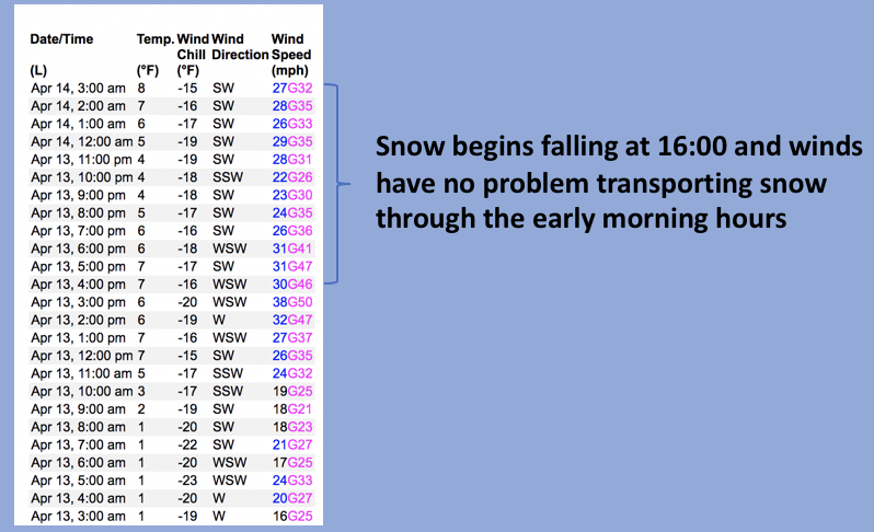
Yesterdays storm was a quick hitter, delivering 4" of snow with .30 H2O. Clouds drape our mountains and temperatures generally register in the mid to upper 20's with a few trailheads hovering right around freezing. West and southwest winds blew in the 40's for most of Saturday and tapered slightly right around 01:00 this morning, but are still obnoxious along the ridges where they average 30 mph. A little shot o' snow goes along way and I think you'll find excellent, cold shallow cream in mid and upper elevation wind sheltered terrain.
FORECAST-
Clouds thin out as the day wares on and temperatures climb into the upper 30's. West and southwest winds begin decreasing in the next couple hours and should blow in the 20's and 30's by days end. Overnight lows under clearing skies dip into the mid 20's.
FUTURECAST-
Dry and warming through the early portion of the week, with a little storm on tap for late Tuesday. A better shot of snow is slated to roll in around Thursday.
Trip reports and snowpack observations are found HERE.

Looking for real-time temps, snow, or wind? Click HERE and then on the "western Uinta" tab for western Uinta specific, weather station network.
Recent Avalanches
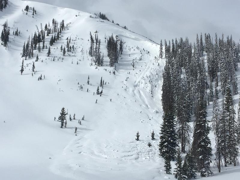
Holy Moffit! Yesterday, Ted spotted this slide on a heavily wind loaded slope near the saddle of Moffit Peak, most likely triggered from a cornice fall late Monday or Tuesday. Breaking 8' deep, 150' wide, and running about 500' vertically, this slide is a bit of an outlier, but an impressive piece of snow none-the-less that could definitely ruin your day. More info found HERE
No other avalanche activity to report.
An archive of recent slides is found HERE.

Your input is vital and we're interested in what you're seeing. Please contribute to this great community resource and go here to fill out an observation.
Ad
Avalanche Problem #1
Wind Drifted Snow
Type
Location
Likelihood
Size
Description
A 24 hour data dump from Windy Peak (10,661') clearly shows no shortage of wind.
Storm snow and strong winds conspire to form a few fresh drifts along the leeward side of upper elevation ridges, especially above treeline in the wind zone. The good news... this avalanche dragon is easy to detect and avoid. Simply steer clear of fat, rounded pieces of snow, particularly if they sound or feel hollow like a drum. And while today's fresh drifts are mostly manageable, they could catch you off guard if one breaks a bit deeper and wider than you might expect. So... if you're tagging a big committing line, think about the consequences of triggering even a small avalanche that can knock you off your skis, board, or sled and throw an unexpected curve ball at your day.
Additional Information
Your observations are important, so please let me know what you're seeing... click HERE and contribute to this amazing community based program
General Announcements
The information in this forecast expires 24 hours after the day and time posted.
Before it gets too crazy, now is the time to book an avalanche awareness presentation for your group, club, or posse. You can reach me directly at 801-231-2170 or [email protected]
This forecast is from the U.S.D.A. Forest Service, which is solely responsible for its content. This forecast describes general avalanche conditions and local variations always occur.