Forecast for the Uintas Area Mountains

Craig Gordon
Issued by Craig Gordon for
Thursday, April 14, 2022
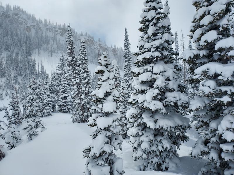
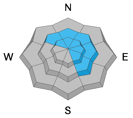
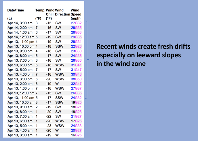
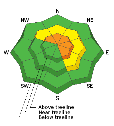
While not widespread, today you'll find pockets of CONSIDERABLE avalanche danger on steep, upper elevation, leeward slopes in the wind zone. Human triggered avalanches are LIKELY, especially in terrain facing the north half of the compass, and particularly on slopes with an easterly component to their aspect. Once triggered, today's avalanches will pack a punch and can easily boss you around.
Slopes facing the north half of the compass near treeline are getting in on the act where MODERATE avalanche danger is found. Mostly manageable in size, fresh wind drifts will react to our additional weight and human triggered avalanches are POSSIBLE on steep, wind drifted slopes.
Lose the wind and you lose the problem. LOW avalanche danger and legit late winter riding conditions are found on slopes facing the south half of the compass and low elevation, wind sheltered terrain where human triggered avalanches are UNLIKELY.
Low
Moderate
Considerable
High
Extreme
Learn how to read the forecast here
Special Announcements
Sunday, April 17th is the last of our regularly scheduled daily forecasts for the western Uinta mountains. But, don't let your heart be troubled... I'll continue to update this page with intermittent forecasts if Mother Nature decides to keep the winter switch turned on.
Weather and Snow
NOWCAST-
The gift that keeps giving... keeps giving! An additional 2" of snow stacked up during yesterday afternoons little snow squall, bringing storm totals into the 14" range. Clouds drifted into the region late yesterday and settled in overnight. Cold, winter-like air remains in place with trailheads registering in the low teens and single digits are the norm near the high peaks. West and southwest winds have been overachieving since early this week and continue in that spirit this morning, blowing in the 20's and 30's along the high ridges. Riding and turning conditions are quite good as storm snow continues piling up and lower angle, wind sheltered terrain is the ticket, where you'll find soft, surfy, snow... along with a bit of alliteration!
FORECAST-
Look for mostly cloudy skies with a scattered snow shower or two developing late in the day. High temperatures warm slightly from past days and climb into the upper 20's. Southwest winds remain a nuisance, blowing in the 30's and 40's near the high peaks. Expect another cool night with lows dipping into the teens.
FUTURECAST-
The work week wraps up with a drying trend and temperatures climbing out of the deep freeze.
Michael J was in lower Weber Canyon yesterday and reports 14" of snow where he traveled and... "Face shots! Yes, it was that good today." More from MJ is found HERE.
Trip reports and snowpack observations are found HERE.

Looking for real-time temps, snow, or wind? Click HERE and then on the "western Uinta" tab for western Uinta specific, weather station network.
Recent Avalanches
Ted was near Gold Hill yesterday and found pockety wind drifts on the leeward side of ridgelines and terrain features. Ted commented.... "Plenty of wind and new snow to blow around and form fresh wind drifts. I was not finding anything too sensitive today, where I traveled the drifts would crack and break off with just some minor sluffing. Possibly a more elevated hazard in the higher exposed terrain. We all know Ted is the man with the Uinta plan and his insights, trip report, and sage advice is found HERE.
No significant avalanche activity to report.
An archive of recent slides is found HERE.

Your input is vital and we're interested in what you're seeing. Please contribute to this great community resource and go here to fill out an observation.
Ad
Avalanche Problem #1
Wind Drifted Snow
Type
Location
Likelihood
Size
Description
A 24 hour data dump from Windy Peak (10,662') show recent strong winds which have no problem whipping fresh storm snow into sensitive drifts in upper elevation terrain.
Yesterday's fresh wind drifts settled out rather quickly, became comfortable in their own skin, and I think that remains the case today for the vast majority of our terrain. However, we all know the Uitna's are a windy place, in fact the range is famous for wind, and above treeline where winds have been busy at work for the past three days... it's a different animal. The good news is... with no myriad of weak layers to deal with or analyze, there's no mystery in the snowpack. In fact, today's avalanche dragon is pretty straight-forward and linear. Easy to detect and easy to avoid, look for and steer clear of both new and old wind drifts which appear fat and rounded or may sound hollow like a drum. Lose some elevation, you lose the wind, you lose the problem, and you're rewarded with a solid base underfoot, topped off with cold, creamy snow.
Additional Information
Your observations are important, so please let me know what you're seeing... click HERE and contribute to this amazing community based program
General Announcements
The information in this forecast expires 24 hours after the day and time posted, but will be updated by 07:00 Friday, April 15th.
Before it gets too crazy, now is the time to book an avalanche awareness presentation for your group, club, or posse. You can reach me directly at 801-231-2170 or [email protected]
This forecast is from the U.S.D.A. Forest Service, which is solely responsible for its content. This forecast describes general avalanche conditions and local variations always occur.