March Kicks Off Our Spring Campaign- Donate Now to Support Forecasting

Forecast for the Uintas Area Mountains

Craig Gordon
Issued by Craig Gordon on
Friday morning, March 7, 2025
Heads up.... avy danger is slightly higher on the south half of the range from Trial Lake to Mill Hollow, Currant Creek, and Strawberry -
In the wind zone at and above treeline, CONSIDERABLE avalanche danger exists on leeward slopes facing the north half of the compass where human-triggered, storm snow and wind-drifted avalanches are LIKELY. Remember... any slide triggered in steep, rocky terrain with a weak, shallow snowpack will result in a deep, dangerous avalanche.
In addition, significant amounts of storm snow blankets our mountains from tip to tail, offering a slightly more straightforward and predictable avalanche dragon and MODERATE avalanche danger. But don't let your guard down... human triggered avalanches packing a punch are POSSIBLE, especially on sustained, steep slopes.
Low
Moderate
Considerable
High
Extreme
Learn how to read the forecast here
Special Announcements
Huge thanks to Randy Sugi, his AA Crew, and to everyone who took time out of their busy lives to join us at last nights Brewvie, sled movie night! 'Twas great to see old friends and make some new friends along the way!
Did you know.... March kicks off our Spring Campaign? Well, if everyone in Utah’s backcountry community donates the cost of something they regularly enjoy on an adventure—like a dawn patrol burrito, a backpack snack, or post-ride trailhead drinks—we could fund not just one but two forecasters for the entire season! More deets here.
Weather and Snow
Nowcast- The gift that keeps giving is starting to wind down, but before leaving the stadium delivered an additional 4" of low density, chin tickling snow overnight. Storm totals are impressive, especially for the south half of the range with nearly two feet of snow, while the North Slope lags in the race with barely half that amount (see detailed storm totals below). As cold air filters into the region, light snow gets squeezed out of mostly cloudy skies and temperatures begin the day in the teens and low 20's... nearly 10 degrees cooler than yesterday at this time. Southwest winds are relatively well behaved, clocking in at just 10-20 mph near the high peaks. Riding and turning conditions are dense and surfy on a go-anywhere base.
Forecast- Look for mostly cloudy skies this morning and scattered snow showers which will add a few more thin layers of white paint... I'm thinking an additional inch or two. Skies turn partly cloudy as the day wares on while winds switch to the west and northwest, blowing in the 20's near the high peaks. Temperatures bump into the mid 20's and dip into the teens overnight.
Futurecast- The weekend looks stunning... mostly sunny skies, light winds, and warming temperatures. More storminess is on tap for Tuesday afternoon into Wednesday with a weak system and a quick reset, followed by a more significant system Wednesday night and continuing into at least Saturday. This storm could bring another couple feet of snow.
Storm totals-
Daniels and Strawberry clock in with 18" snow and 2.0" SWE.
Upper Currant Creek and Mill Hollow register 17" of snow and I suspect closer to 1.7" H2O.
Trial Lake... 15" of snow and 1.5" H2O
Chalk Creek delivers 6" snow with .70" SWE
Recent Avalanches
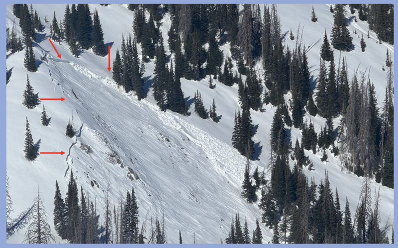
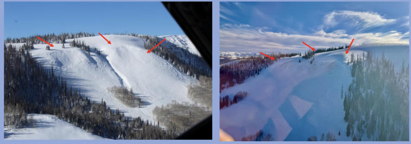
No significant avalanches reported since February 25th, but the image above from Gold Hill, depicts exactly the type of slide we could trigger today in steep, rocky, wind drifted terrain.
Also, no shortage of good reading from across the range and beyond, here.
Ad
Avalanche Problem #1
Persistent Weak Layer
Type
Location
Likelihood
Size
Description
The recent storm is gonna put our weak layers to the test, especially where the snowpack has remained thin and sugary all year, like slopes that have avalanched multiple times. Problem is, everything is gonna look white and uniform and feel super solid under our sled, board, or skis. So, I'm approaching steep, shady slopes with a "guilty until proven otherwise" mindset. I'm keeping it tight and simply avoiding shallower areas of the snowpack like steep, rocky terrain where I'm more likely to trigger an avalanche that breaks deeper and wider than I might expect. In addition, if I decide to step out, I'm gonna make sure the slopes I'm choosing don't have any overhead hazard.
North of Race Track Bowl, above is an example of a repeater slope... meaning it's avalanched several times this winter. Left image illustrates the precursor... this slope slid during the Christmas cycle and left behind a shallow, weak snowpack. On the right, a slide triggered low on the slope on Feb. 22nd with nearly the same dimensions and snow characteristics... not what we expect for this deep in the season.
Avalanche Problem #2
Wind Drifted Snow
Type
Location
Likelihood
Size
Description
A 24 hour data dump form Lofty Lake Peak (11,186') illustrating wind velocity, direction, and duration.
Snow falling out of the sky overnight camouflages yesterdays wind slabs, making them harder to detect. Looking at wind sites from around the range throughout the storm here's what I suspect... drifts formed mostly on the leeward side of ridges in terrain facing the north half of the compass, though I wouldn't be too surprised to find an old drift or two lurking around a terrain feature like a chute or gully wall. In either case, I'm looking for and avoiding fat, rounded pieces of snow, especially if they sound hollow like a drum.
My strategy is simple... lose a little elevation and I lose the problem.
Avalanche Problem #3
New Snow
Type
Location
Likelihood
Size
Description
There's alot of storm snow and a myriad of old, hard, slick surfaces which provide an efficient surface for avalanches to run on. If the sun comes out for just a few minutes it'll change the equation and the fresh snow will get touchy in a hurry. I suspect sustained steep slopes is where the rubber hits the road and that's exactly the kind of terrain where even a small slide can catch me off-guard and knock me off my feet.
Additional Information
The Camp Steiner snow site, just east of Scout Peak and south of Lofty Peak, was upgraded with a new snow sensor and is cranking out accurate snow depths just in time for the first spring storm! This is a great weather station that provides information specific to the north slope, high-country, and Mirror Lake environs. You can access all the stations across the range, here.. click on western Uinta tab.
Installing the new snow depth sensor at Camp Steiner just below Scout Peak. When you bring your brother to work, you have to put him to work -- Thanks for the install, Kyle!
General Announcements
We are always looking for snow and avalanche observations or just general riding conditions. In the meantime reach out to us with questions, concerns, or if you see anything in your travels! Contact us directly through the info below:
This forecast is from the U.S.D.A. Forest Service, which is solely responsible for its content. This forecast describes general avalanche conditions and local variations always occur. This forecast was issued on Friday, March 7th at 04:00 AM and expires 24 hours after it was issued.