Forecast for the Uintas Area Mountains

Craig Gordon
Issued by Craig Gordon for
Wednesday, March 30, 2022
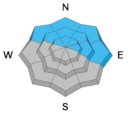
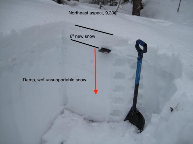
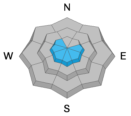
Near and above treeline, pockets of CONSIDERABLE avalanche danger exist. Human triggered avalanches failing on the midwinter drought layer (PWL) and breaking several feet deep remain LIKELY, especially on slopes facing the north half of the compass. MODERATE avalanche danger is found below treeline and human triggered avalanches breaking to this weak layer are POSSIBLE.
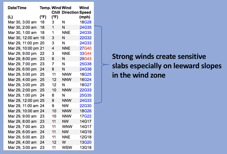
A MODERATE avalanche danger is found on steep, leeward terrain in the wind zone, where fresh wind drifts are gonna react to our additional weight and human triggered avalanches are POSSIBLE.
If you're looking for LOW avalanche danger, simply swing over to low and mid elevation slopes facing the south half of the compass where new snow rests on a variety of old, melt-freeze snow surfaces.

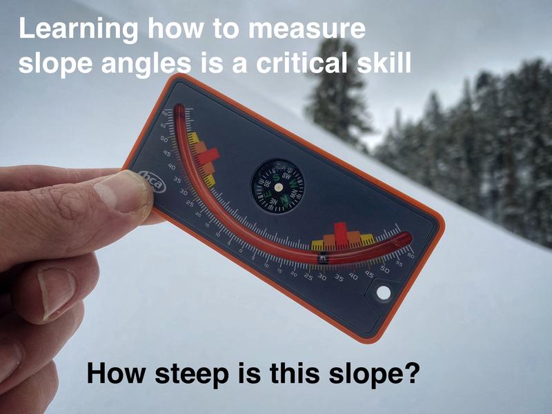
Scroll to the bottom for a note on slope angle and how to have a blast without entering avalanche terrain.
Low
Moderate
Considerable
High
Extreme
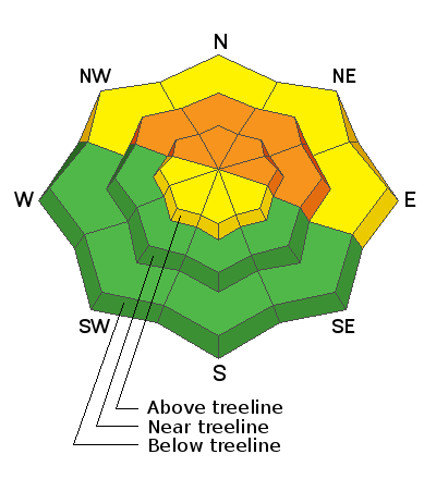
Learn how to read the forecast here
Special Announcements
Two generous UAC supporters are challenging the community to invest in the future of the UAC’s forecasting program during the 2022 Spring Campaign. They will match your donation, dollar for dollar, up to $10,000. Donate today to support avalanche forecasting! Click HERE for more deets.
Weather and Snow
NOWCAST-
The Uinta's can really light up this time of year and yesterday's spring showers helped the range live up to my cautiously optimistic expectations. Don't get discouraged as you pull up to a melted out parking lot because storm snow totals increase in depth as you gain elevation... a trace of storm snow at the trailheads turns to about 4" at mid elevations and then 8" in the high country. Under mostly cloudy skies, light snow showers linger as one last burst of moisture slides through the region. Northerly winds blew in the 40's for a good chunk of Tuesday, but settled into a more reasonable 20-35 mph range at the turn of the new day. Temperatures are noticeably cooler, registering in the upper teens and mid 20's. Riding and turning conditions have improved and I think there's a mostly supportable base underfoot and undertrack.
FORECAST-
Snow showers linger for the early morning, but become spotty as high pressure builds over the area, producing partly skies. High temperatures climb into the mid 30's with overnight lows dipping into the 20's. Northerly winds mellow somewhat and decrease into the 20's as the day progresses.
FUTURECAST-
Another shot of snow slated for Thursday with a break in the action to round out the work week.
Ted found it rough going with barely supportable conditions yesterday near Gold Hill and says... "As soon as I left the groomed trail I was sinking into damp unsupportable snow with water at the ground level. This was at the 8,700' elevation." Ted also adds... "I was finding similar snow conditions at 9,500' with slightly more new snow, but the snow was still unsupportable and damp to the ground. I sunk to my knees once I stepped off the machine."
Trip reports and snowpack observations are found HERE.

Looking for real-time temps, snow, or wind? Click HERE and then on the "western Uinta" tab for western Uinta specific, weather station network.
Recent Avalanches
No significant avalanche activity to report in the past few days.
An archive of recent slides is found HERE.

Your input is vital and we're interested in what you're seeing. Please contribute to this great community resource and go here to fill out an observation.
Ad
Avalanche Problem #1
Persistent Weak Layer
Type
Location
Likelihood
Size
Description
Ted's pit profile from yesterday doesn't offer a whole lotta love, but I think colder temperatures will help us turn the corner... we just need to exercise a bit of patience for a minute or two.
What's the deal?
From cold to warm to warmer and even warmer yet, but now slowly cooling off, the snowpack has been yanked all over the place in the past week. Sure, we saw some natural avalanche activity with slides failing on our problem child, the persistent weak layer (PWL) of sugary, faceted snow formed by the mid winter dryspell, but the range didn't exactly come unglued. The good news is... I bet the short term pain will be long term gain for our snowpack, but before diving headfirst back into the snow I think it'll proceed with caution and consider the PWL guilty until proven otherwise.
Where does the PWL exist?
It's widespread on wind sheltered, NW-N-NE-E facing slopes near and slightly below treeline. What makes this setup so tricky is this is exactly the type of terrain we ride when it's stormy or when the avy danger is elevated. Above treeline in alpine terrain, it's distribution is more pockety.
Where and how to ride?
It's been an unusual run of weird weather, it's an atypical snowpack, and that means we need to gather some solid snow beta before comfortably getting after it and into big terrain. During your ride today, tweak small test slopes and see how they're reacting. Is your track gouging into weak, sugary snow or if you step off your machine do you sink into an unsupportable mess of damp snow. If that's case then we still need to allow some time for the snowpack to come around and gain some strength. Remember... change happens quick in the spring and I think a little patience now will deliver solid returns in the near future.
Avalanche Problem #2
Wind Drifted Snow
Type
Location
Likelihood
Size
Description
Above is a 24 hour data run from Windy Peak (10,662') illustrating recent wind trends.
Strong ridge top winds easily transported recent storm snow to the leeward side of upper elevation ridges and those will be sensitive to our additional weight. And while you can expect shallow fresh wind drifts in the usual suspect slopes, I wouldn't be too surprised to see a few fresh drifts around terrain features like chutes and gullies. In either case, you know the drill by now... lose the wind and you lose the problem.
Additional Information
AVALANCHE TERRAIN:
Slope angle determines where avalanches can happen and where they can't. Generally, any slope steeper than 30 degrees is where avalanches occur. This means all you need to do is ride slopes less than 30 degrees in steepness and you'll never have to deal with avalanches.
There's a catch! You can't be underneath slopes steeper than 30 degrees either, even if you're on a flat slope, because avalanches can crash down on you. It turns out that skiing or riding slopes about 25 degrees in steepness is really fun and even more fun because there's no worry of avalanches. Unfortunately, it takes a lot of practice to estimate slope angles with your eyes alone. The way to get practice and the only way to know for sure is to measure slope angles with slope measuring tool shown in the photo below, and Toby describes it in this video. There are also many apps so that you can use your phone in a similar manner.

Your observations are important, so please let me know what you're seeing... click HERE and contribute to this amazing community based program
General Announcements
The information in this forecast expires 24 hours after the day and time posted, but will be updated by 07:00 Thursday, March 31st.
Before it gets too crazy, now is the time to book an avalanche awareness presentation for your group, club, or posse. You can reach me directly at 801-231-2170 or [email protected]
This forecast is from the U.S.D.A. Forest Service, which is solely responsible for its content. This forecast describes general avalanche conditions and local variations always occur.