Forecast for the Uintas Area Mountains

Mark Staples
Issued by Mark Staples for
Friday, March 25, 2022
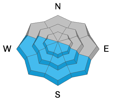
Today, a buried persistent weak layer remains surprisingly reactive and will produce human triggered avalanches on slopes near and above treeline generally facing north and east where the avalanche danger is CONSIDERABLE. Below treeline, avalanches may still occur on this layer and the danger is MODERATE.
South and west facing terrain has been cooked by strong sunshine, but will heat up fast this morning. As the snow becomes wetter, the danger will rise to MODERATE for wet loose avalanches. These should be small and occur predictably as the day progresses.

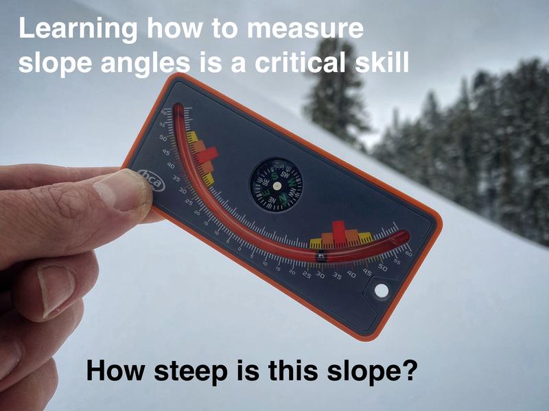
Scroll to the bottom for a note on slope angle and how to have a blast without entering avalanche terrain.
Low
Moderate
Considerable
High
Extreme
Learn how to read the forecast here
Special Announcements
Please help support avalanche forecasting throughout Utah during the Spring fundraising Campaign. Go HERE for more info on how to provide a little support.
Weather and Snow
NOWCAST-
Air temperatures this morning are hovering a little above or below freezing at most weather stations; however, clear skies allowed the snow surface to refreeze after becoming damp yesterday. Winds are blowing 12-24 mph from the west. Most slopes should have an ice crust on the surface that should melt by mid morning.
FORECAST-
Today will be similar to yesterday but a little warmer. There will be lots of strong sunshine, clear skies, and high temperatures climbing well into the 40s F. Winds will blow 15-25 mph and eventually come from the southwest later today bringing more warm air.
FUTURECAST-
Record-setting temperatures are forecasted for this weekend with nearly 80 degree high temperatures expected along the Wasatch Front. This weekend will be beautiful and a great time to enjoy the snow or dirt or whatever sport you pursue.
Yesterday I was fortunate to ride with folks from the Utah Division of Recreation and tour around the Mirror Lake Highway. It was a little tough keep the sleds cool in the morning on refrozen snow; otherwise, it was a great day to be out looking at avalanche conditions. Photo below from the east side of Bald Mountain.
Trip reports and snowpack observations are found HERE.

Looking for real-time temps, snow, or wind? Click HERE and then on the "western Uinta" tab for western Uinta specific, weather station network.
Recent Avalanches
Yesterday along the Iron Mountain road, we were able to trigger small road cuts (photo below)...when the small hills are sliding, watch out for the bigger ones. We also experienced one large collapse which was basically an avalanche except that the slope we were on wasn't steep enough to slide.
Early this week a group of skiers near Boundary Creek experienced widespread thunderous collapses and long shooting cracks (50-100 ft) throughout their travels.


Your input is vital and we're interested in what you're seeing. Please contribute to this great community resource and go here to fill out an observation.
Ad
Avalanche Problem #1
Persistent Weak Layer
Type
Location
Likelihood
Size
Description
A persistent weak layer (PWL) of weak, faceted snow is buried 1-3 feet deep. It is hard to believe that it is lurking in the snow despite such warm weather. When you see it and feel it, it's almost shocking how dry and loose it is (like a layer of sugar). The snowpack continues to show us that this layer will fracture and produce avalanches.
Where does it exists? It is widespread on NW-N-NE-E facing slopes near and slightly below treeline. Above treeline in alpine terrain, it's distribution is more pockety.
What will the warm weather do? For now, "all bets are off" and conditions remain dangerous. In the long run, the warmth will help this layer slowly heal. The wild card is that if there's enough heat to melt snow and cause liquid water to percolate down to this layer, then avalanches would start happening on their own.
Avalanche Problem #2
Wet Snow
Type
Location
Likelihood
Size
Description
Strong sunshine and very warm air temperatures will quickly soften and melt snow on south and west facing slopes. These slopes have been through several melt-freeze cycles, and you may find some that have decent corn snow. Others will have slushy snow today. As the snow becomes wetter and wetter, small wet loose avalanches may occur this afternoon, but I don't expect them to be a widespread issue in the Uintas that tend to stay a little cooler than the Wasatch Mountains.
Look for snowballs rolling downhill with increasing frequency as a sign that wet avalanches may start happening. Typically they happen near exposed rocks or cliffs that absorb extra heat from the sun and reradiate that heat into the surrounding snow.
Additional Information
AVALANCHE TERRAIN:
Slope angle determines where avalanches can happen and where they can't. Generally, any slope steeper than 30 degrees is where avalanches occur. This means all you need to do is ride slopes less than 30 degrees in steepness and you'll never have to deal with avalanches.
There's a catch! You can't be underneath slopes steeper than 30 degrees either, even if you're on a flat slope, because avalanches can crash down on you. It turns out that skiing or riding slopes about 25 degrees in steepness is really fun and even more fun because there's no worry of avalanches. Unfortunately, it takes a lot of practice to estimate slope angles with your eyes alone. The way to get practice and the only way to know for sure is to measure slope angles with slope measuring tool shown in the photo below, and Toby describes it in this video. There are also many apps so that you can use your phone in a similar manner.

Your observations are important, so please let me know what you're seeing... click HERE and contribute to this amazing community based program
General Announcements
The information in this forecast expires 24 hours after the day and time posted, but will be updated by 07:00 Friday, March 25th.
Before it gets too crazy, now is the time to book an avalanche awareness presentation for your group, club, or posse. You can reach me directly at 801-231-2170 or [email protected]
This forecast is from the U.S.D.A. Forest Service, which is solely responsible for its content. This forecast describes general avalanche conditions and local variations always occur.