March Kicks Off Our Spring Campaign- Donate Now to Support Forecasting

Forecast for the Uintas Area Mountains

Craig Gordon
Issued by Craig Gordon on
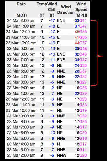
Wednesday morning, March 24, 2021
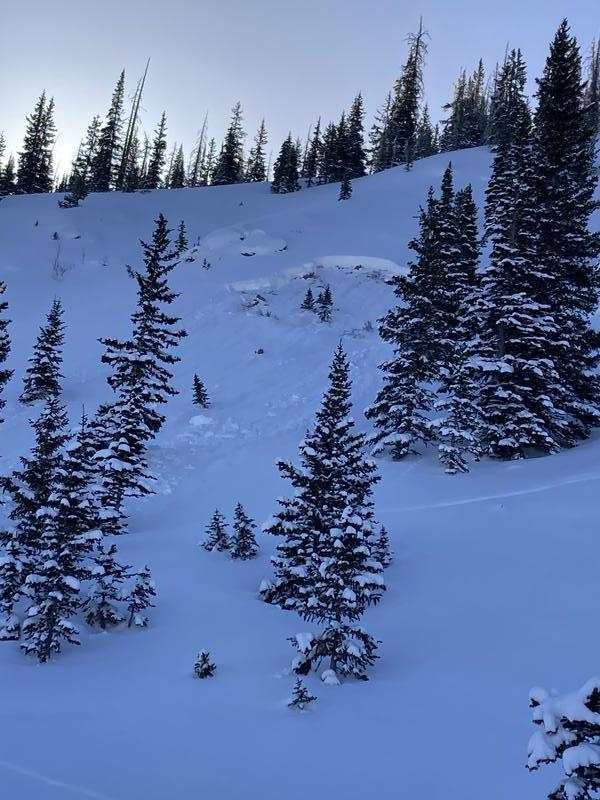
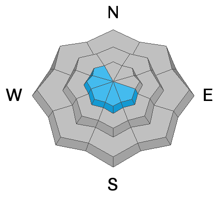
In the wind zone, at and above treeline you'll find MODERATE avalanche danger. Human triggered avalanches are POSSIBLE on steep, wind drifted, leeward slopes, especially those with a westerly component to its aspect.
And here's something to consider... if you're getting into steep, technical terrain, even a small slide can knock you off your ride, potentially slam you into a tree, and deliver a season ending injury... or worse.
Lose some elevation and you lose most of the problem. Mid and low elevation wind sheltered terrain offers generally LOW avalanche danger.
Low
Moderate
Considerable
High
Extreme
Learn how to read the forecast here
Special Announcements
Our Spring Avy Awareness Campaign is in full swing from March 16th- March 30th. Please help us save lives through avalanche forecasts and education. Consider making a donation to show your support.
Weather and Snow
Nowcast-
As Tuesday's storm exits the stadium headed for the four corners, strong northeast winds crashed the powder party late yesterday afternoon, blowing into the 40's and 50's overnight. Currently, skies are clear, temperatures in the teens and single digits, and northeast winds are diminishing somewhat, yet still blow in the 30's. Riding and turning conditions took a hard hit and our big open terrain got ravaged by the wind. But.... it'll be a beautiful day in the mountains and I bet you can still find soft, settled snow in mid elevation wind sheltered terrain or shift your focus to the south half of the compass and go for something that resembles supportable corn.
Forecast-
Look for mostly sunny skies, high temperatures warming into the low 30's, and winds tapering off throughout the day.
Futurecast-
A disorganized system slides into the region Thursday morning, bringing scattered snow throughout the day. A better shot for more consistent snow stacking up moves into the area Friday and we may see storm totals in the 4"-8" range before high pressure takes over for weekend.
Looking for real-time temps, snow, or wind?
Click HERE and then on the "western Uinta" tab for western Uinta specific, weather station network.
Recent Avalanches
Michael Davis was in the Gold Hill zone Monday and caught sight of these two slides. The top image is fairly recent and perhaps triggered earlier in the day. While small and pockety, the main take home is it broke to weak snow near the ground and could definitely ruin your day if it slammed you into a tree. The second image is of an older, more connected slide, which I think is a repeater and illustrates similar properties. For more on Michaels travels and a most excellent trip report click HERE.

Observations, trip reports, and avalanches found here.
Ad
Avalanche Problem #1
Wind Drifted Snow
Type
Location
Likelihood
Size
Description
A 24 hour data dump from Windy Peak (10,662') illustrates the uptick in wind right around 16:00 hours yesterday.
Dang... and then the northeast winds blew... and there's plenty of snow available for transport. Now, here's the tricky part- east and northeast winds load snow in unusual locations, creating drifts in terrain with a westerly component to its aspect. While I think today's wind drifts are hard and stubborn, they may break a bit wider than you'd expect. And once triggered, could knock you off your skis, board, or sled. You can easily avoid triggering a fresh slab by avoiding the problem. Simply look for and steer clear of fat, rounded pillows of snow, especially if they sound or feel hollow like a drum. And you don't have to ride blind... tweak small test slopes like road cuts to see how they're reacting before tagging big terrain or committing to pre-planned objectives.
Additional Information
I will update this forecast by 7:00 AM tomorrow, Thursday, March 24th.
Your observations are important, so please let me know what you're seeing... click HERE and contribute to this amazing community based program
General Announcements
If you see or trigger an avalanche or just wanna let me know what you're seeing you can reach me directly at 801-231-2170 or [email protected]
This forecast is from the U.S.D.A. Forest Service, which is solely responsible for its content. This forecast describes general avalanche conditions and local variations always occur.