March Kicks Off Our Spring Campaign- Donate Now to Support Forecasting

Forecast for the Uintas Area Mountains

Craig Gordon
Issued by Craig Gordon on
Saturday morning, March 20, 2021
Today's avalanche hazard is pretty straightforward and easily managed with terrain choices which include aspect, elevation, and slope angle-
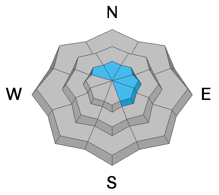
In the wind zone, at and above treeline you'll find MODERATE avalanche danger and human triggered avalanches are POSSIBLE, especially on steep, wind drifted, leeward slopes facing the north half of the compass.
And here's something to consider... if you're getting into steep, technical terrain, even a small slide can knock you off your ride, potentially slam you into a tree, and throw a curve ball at your day.
Lose some elevation and you lose most of the problem and get some great riding to boot!
Mid and low elevation wind sheltered terrain offers generally LOW avalanche danger.
Low
Moderate
Considerable
High
Extreme
Learn how to read the forecast here
Special Announcements
Our Spring Avy Awareness Campaign is in full swing from March 16th- March 30th. Please help us save lives through avalanche forecasts and education. Consider making a donation to show your support.
Weather and Snow
Nowcast-
High clouds drifted into the region last night and temperatures remained rather mild overnight, currently reading in the high 20's and mid to upper 30's. Southwest winds began ramping up late Friday and continue on this trend this morning with hourly averages in the 50's and gusts near 70 mph along the high peaks. There's a variety of riding conditions out there this morning and a mixed bag of snow surfaces... none offer a "drop everything you're doing" kind of urgency. Snow develops in the next couple of hours, so maybe get a few chores done, wait for some fresh snow to stack up and get after it later in the day.
Forecast-
Southwest winds nuke through late morning and then shift to the west-northwest and decrease as a cold front crosses our region right around suppertime. Snow begins stacking up in earnest and temperatures dive into the 20's with the arrival of colder, more unstable air. In addition, lightening is a good possibility. A good shot of snow stacks up 8"-10" by the time things wind down overnight.
Futurecast-
Snow showers linger into Sunday morning, a break Monday, and then a slightly stronger storm for late Monday/Tuesday.

Looking for real-time temps, snow, or wind?
Click here and then on the "western Uinta" tab for western Uinta specific, weather station network.
Recent Avalanches
No significant avalanche activity to report

Observations, trip reports, and avalanches found here.
Ad
Avalanche Problem #1
Wind Drifted Snow
Type
Location
Likelihood
Size
Description
Strong winds and a little fresh snow create wind drifts sensitive to our additional. It's a fairly straight-forward avalanche problem with most of our issues confined to steep, leeward, upper elevation terrain. But remember... strong winds cross-load terrain features like chutes and gullies and load snow lower downslope than we usually expect to see. In either case, as snow begins stacking up, look for and avoid fat, rounded pillows of snow, especially if they sound or feel hollow like a drum.
Additional Information
I will update this forecast by 7:00 AM tomorrow, Sunday, March 21st.
Your observations are important, so please let me know what you're seeing... click HERE and contribute to this amazing community based program
General Announcements
If you see or trigger an avalanche or just wanna let me know what you're seeing you can reach me directly at 801-231-2170 or [email protected]
This forecast is from the U.S.D.A. Forest Service, which is solely responsible for its content. This forecast describes general avalanche conditions and local variations always occur.