Forecast for the Uintas Area Mountains

Craig Gordon
Issued by Craig Gordon for
Monday, March 14, 2022
HEADS UP -
Deceptively dangerous avalanche conditions exist for this time of year, especially on slopes facing the north half of the compass. Here's the catch... sunny skies, fresh snow, and outstanding late season riding lure us into thinking conditions are safer than they are and we're good to go. The snowpack isn't sharing our same emotions.
CONSIDERABLE avalanche danger exists today. Dangerously deep, human triggered avalanches are likely on all slopes (even well below treeline) facing NW, N, NE, and E, especially those with recent deposits of wind drifted snow. Any avalanche that breaks to old snow has the potential to deliver a devastating curve ball to your day.
Slopes facing west and south near and above treeline generally do not have a weak layer of facets, but with so much new snow, avalanches on theses slopes remain possible and the danger is MODERATE.
Looking for LOW avalanche danger? Well, then you've got plenty of options. Simply steer towards mid and lower elevation sunny slopes or choose a big, open meadow with no steep slopes above or adjacent to where you're riding.
Low
Moderate
Considerable
High
Extreme
Learn how to read the forecast here
Weather and Snow
NOWCAST-
What a nice reset! Yesterday's North Slope-centric storm delivered a solid 6" of medium density snow to the Chalk Creek zone, 9" around Bald Mountain, and about half that amount piling up on the south half of the range. Skies cleared overnight, allowing temperatures to dive into the teens and single digits. Ridge punishing, west and southwest winds blew in the 30's and 40's for most of Sunday, but finally relaxed late last night, switched to the northwest, and currently blow 10-20 mph near the high peaks. Riding and turning conditions are quite good, especially on low angle slopes which are fast and fun. Get out and get after it before the sun beats you in the race against dry powder and damp glop.
FORECAST-
A few clouds linger over the high peaks, but should be quickly clearing out in the next few hours. High temperatures climb into the low 30's with overnight lows dipping into the 20's. Well behaved northwest winds blow 10-20 mph along the high ridges.
FUTURECAST-
Another quick hitting storm is slated for midweek.
Trip reports and snowpack observations are found HERE.

Looking for real-time temps, snow, or wind? Click HERE and then on the "western Uinta" tab for western Uinta specific, weather station network.
Recent Avalanches
The image above illustrates the fine line between having a great day or one that can go sideways in a hurry. A very close yesterday near Humpy Peak Saturday leaves one rider and his sled buried and wrapped around a tree with a portion of his airbag showing. We are sifting through deets and will have more info posted if and when it filters in.
No shortage of both natural and human triggered avalanches reported last weekend-

Your input is vital and we're interested in what you're seeing. Please contribute to this great community resource and go here to fill out an observation.
Ad
Avalanche Problem #1
Persistent Weak Layer
Type
Location
Likelihood
Size
Description
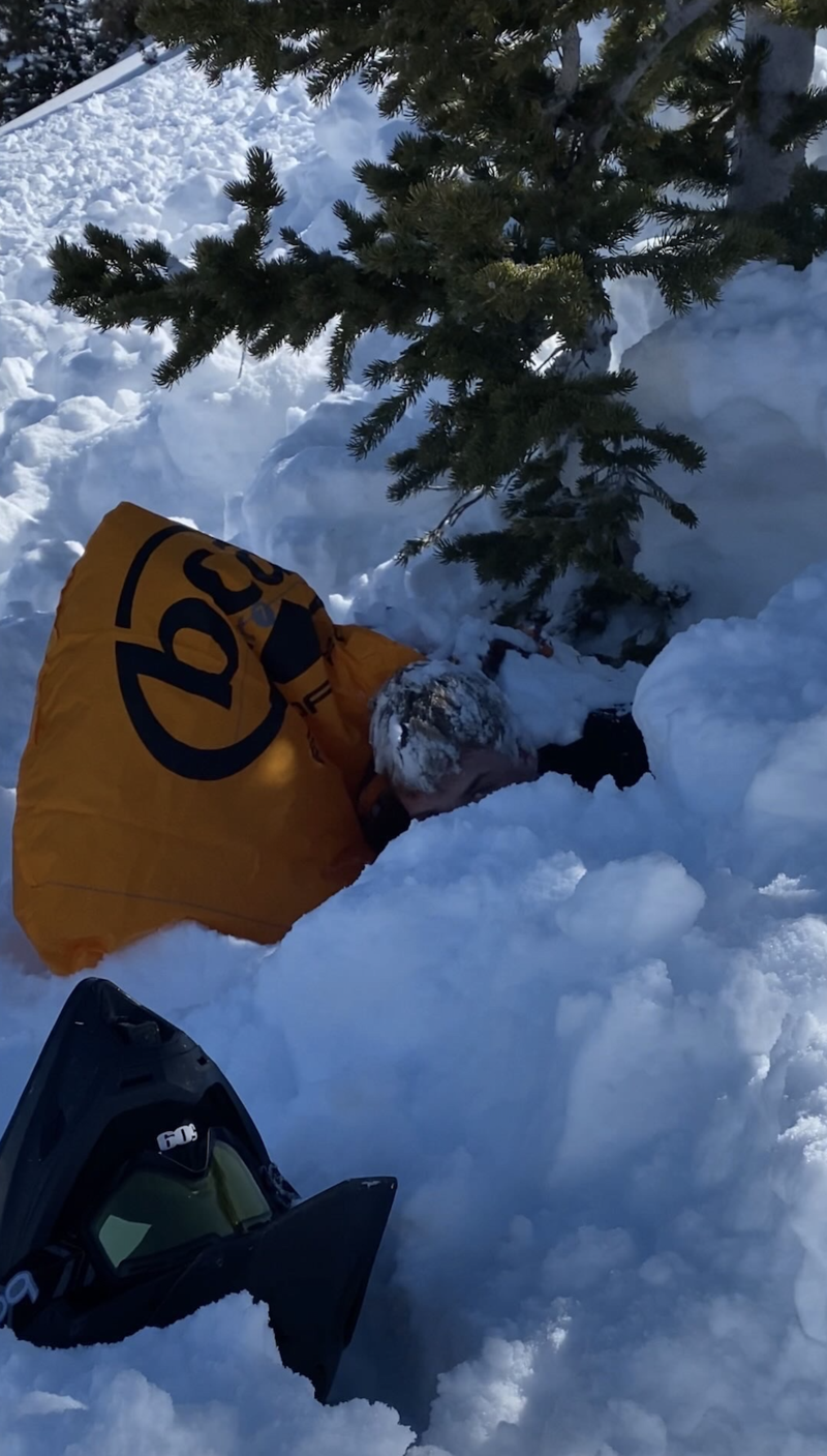
"I can’t remember a time that I’ve seen more red flags in one ride. We observed widespread cracking and collapsing. Avalanches were easily triggered on any test slope steeper than 30 degrees."
Snowpro, avy educator extraordinaire,Wasatch SAR member, pro sledder, and all around great guy Tyler St. Jeor states it best in his comment from Saturday.
Here's the deal-
Remember the big dryspell during January/February? (You're thinking to yourself... hmmm, "I forget what time I drop the kids off for soccer practice today.") Well, that midwinter drought helped create a weak layer of faceted, sugary snow which is now buried under several layers worth of storm snow from last week. And while we might forget everyday occurrences, the snowpack has an amazing memory. In fact, now that this layer is buried, it's our new problem child, or persistent weak layer (PWL).
Chads viddy above illustrates the problem. We've got an unusual, late season, set up... strong snow on top of weak snow. And the weak layer is easily failing under our additional weight and will produce deep, dangerous avalanches today. Like a layer of dominoes with stronger snow resting on top, once our skis or track tip the first domino, it sets off a chain reaction in which all the dominoes (PWL) collapse. It's sorta like pulling the rug out from underneath, and the entire roof crashes down on us! Here's where it gets tricky... we don't even need to be on a steep slope, just near or connected to it (at the top, bottom, or to the side). Tip one of the dominoes over and now we're staring down the barrel of a scary avalanche!
What makes this situation tricky?
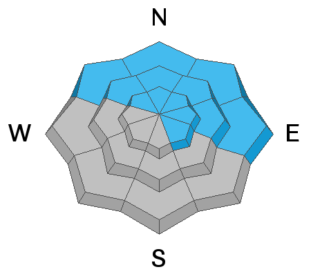
  1. We don't normally deal with long lasting avalanche problems like this, lingering deep into the winter. Today's avalanches act more like early and mid season slides that break on sugary snow near the ground except in this case avalanches will break in the middle of the snowpack. Avalanches may also break in areas below treeline where we don't often expect to see as many slides.
  2. You can trigger deep, dangerous avalanches by simply being near a steep slope but not necessarily on it.
  3. This weak layer is found on many slopes but not all, especially in the wind zone, where distribution is spotty and that makes stability patterns tricky to get a handle on. So... you might find weak snow on one part of a slope but not the other. This means you may see people ride a slope and not trigger a slide, but the second or third person on that same slope may be the one to trigger and avalanche.
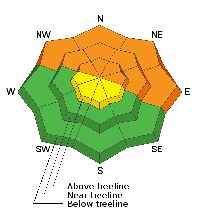
What to do? There are two options. Ride southerly facing slopes that don't have this weak layer, but the problem is they have a much thinner snowpack. Terrain facing the north half of the compass offers a deeper snowpack and cold powder, but likely have this weak layer and are unstable. In those areas, simply ride slopes less than 30 degrees in steepness with no overhead hazard... and that means nothing steeper above you.
Avalanche Problem #2
Wind Drifted Snow
Type
Location
Likelihood
Size
Description
Above is a 24 hour data dump form Windy Peak (10,661') showing a long stretch of robust winds.
Winds were all over the map and they've got no shortage of fresh snow to work with. Pretty straight-forward and found mostly on leeward slopes in the wind zone above treeline, also be on the look out for fresh drifts that formed around terrain features like chutes and gullies. The good news, it's an easy avalanche dragon to manage. Simply avoid fresh wind drifts that'll look fat and rounded or might sound hollow like a drum. Lose the wind and you lose the problem.
Additional Information
Your observations are important, so please let me know what you're seeing... click HERE and contribute to this amazing community based program
General Announcements
The information in this forecast expires 24 hours after the day and time posted, but will be updated by 07:00 Tuesday, March 15th.
Before it gets too crazy, now is the time to book an avalanche awareness presentation for your group, club, or posse. You can reach me directly at 801-231-2170 or [email protected]
This forecast is from the U.S.D.A. Forest Service, which is solely responsible for its content. This forecast describes general avalanche conditions and local variations always occur.